
Murrayfield is an area to the west of Edinburgh city centre in Scotland. It is to the east of Corstorphine and north of Balgreen, Saughtonhall and Roseburn. The A8 road runs east–west through the south of the area. Murrayfield is often considered to include the smaller neighbouring areas of Ravelston and Roseburn.
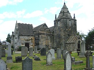
Corstorphine is an area of the Scottish capital city of Edinburgh. Formerly a separate village and parish to the west of Edinburgh, it is now a suburb of the city, having been formally incorporated into it in 1920.

South Gyle is an area of Edinburgh, Scotland, lying on the western edge of the city and to the south and west of an area of former marshland once known as the Gogarloch, on the edge of Corstorphine. Most of the buildings in the area are of recent origin, dating from the later 1980s, 1990s, and early 21st century, with the exception of some farm workers' cottages and an early 1970s council estate abutting South Gyle railway station.

East Craigs is a residential district of Edinburgh located in the north-west of the city, on the western flanks of Corstorphine Hill. It lies next to what remains of the green belt, and prior to development was a working farm.
Gogarloch is a residential area within South Gyle, Edinburgh, Scotland. It lies near South Gyle railway station and South Gyle Broadway, 4+1⁄2 miles (7.2 km) west of the city centre. Corstorphine and Wester Broom are nearby.

Craigcrook is a suburb of Edinburgh, Scotland, best known for Craigcrook Castle. It is fairly affluent, and lies on the north east slopes of Corstorphine Hill. It is near Clerwood, and Blackhall. Davidson's Mains lies to the north, separated from the district by the A90 - Queensferry Road.

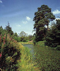
Corstorphine Hill is a low ridge-shaped hill rising above the western suburbs of Edinburgh, Scotland. Although there has been residential and commercial development on its lower slopes, especially in the south and west, most of the hill is occupied by a local nature reserve, consisting of extensive broadleaf woodland, accessible to the public.
Drumbrae or Drum Brae is the name of a suburb of west Edinburgh, Scotland generally considered to be part of the neighbouring larger areas of Corstorphine and Clermiston. This is a commuter settlement as many people who live in the area travel to the centre of town to attend work.

Maybury is an area on the western edge of Edinburgh, Scotland, near South Gyle and Ingliston, named after the road, which is itself named after the civil engineer Sir Henry Maybury (1864–1943). In 2021, residents have been undertaking community clean ups to clear the foot paths along the road. The area is residential in the north east/east and commercial in the south and west and The Gyle Shopping Centre is nearby. In 2021, there was a consultation about creating a Primary School and Health Centre in Maybury.
Bughtlin is a suburb of Edinburgh, the capital of Scotland. It is east of the A902.
Cammo is a northwestern suburb of Edinburgh, the capital of Scotland. It is south of A90, at the edge of the city, approximately 6 miles from the city centre.

Hermiston is a hamlet formerly in the county of Midlothian and now part of Edinburgh, the capital of Scotland. It is north of Heriot-Watt University's Riccarton Campus and west of the Hermiston Gait commercial development. Hermiston is bounded by the A71 Calder Road to the south and the Union Canal to the north with the M8 motorway just beyond. The hamlet forms the Hermiston Conservation Area.

Ingliston is an area in the west of Edinburgh, near Maybury, South Gyle and Newbridge.
Ravelston is an area of Edinburgh, Scotland, to the west of the city centre, the east of Corstorphine and Clermiston, the north of Murrayfield, West End and Roseburn and to the south of Queensferry Road. Ravelston is often considered to be part of the larger neighbouring area of Murrayfield.
West Coates or Wester Coates is a residential district of central Edinburgh, the capital of Scotland. It is on the A8, in proximity to Haymarket railway station and Roseburn, west of the city centre, bounded by the Water of Leith on its north side.
Carrick Knowe is a suburb in the west of Edinburgh in Scotland, located approximately 3 miles from the city centre. It is bordered by Tyler's Acre to the north, the Glasgow/Aberdeen railway line to the south, Carrick Knowe Golf Course to the east, and Saughton Road North to the west. The catchment area for the primary school encompasses this entire area. It is often considered part of Corstorphine, however it has its own shopping areas, primary school, parish church and public park.

The Forresters are an ancient and noble clan of the Scottish Lowlands.
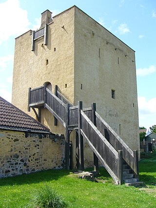
Liberton Tower is a four-storey, square-plan tower house in the Edinburgh suburb of Liberton, on the east side of the Braid Hills.
Forrester is a primarily residential area of Corstorphine, Edinburgh which has its own high school and rugby club. The closest railway stations are at South Gyle and Edinburgh Park, but it is itself wedged between the two railway lines. It is not to be confused with "Forrester Road", which is on the other side of Corstorphine on the slopes of Corstophine Hill. It is named for the Forrester Family, who used to be the lairds of Corstorphine.

Corstorphine/Murrayfield is one of the seventeen wards used to elect members of the City of Edinburgh Council. Established in 2007 along with the other wards, it currently elects three Councillors.
