Lochmoor Waterway Estates is a census-designated place (CDP) in Lee County, Florida, United States. The population was 3,858 at the 2000 census. It is part of the Cape Coral-Fort Myers, Florida Metropolitan Statistical Area.

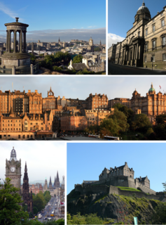
Edinburgh South West is a Scottish constituency of the House of Commons of the Parliament of the United Kingdom (Westminster), first used in the 2005 general election. It elects one Member of Parliament (MP) by the first past the post system of election.

Abbeyhill is an area of Edinburgh, the capital of Scotland.

Blackford is an area in the south of Edinburgh, the capital city of Scotland. It is located near Morningside, and The Grange. Blackford Hill dominates the view to the south. The vast majority of Blackford is housing, mostly of late Victorian or Edwardian age.

Wester Hailes is an area in the south west of Edinburgh, Scotland.
Longstone is a suburb of Edinburgh in Scotland. It borders Saughton, Wester Hailes, Slateford, Kingsknowe and Parkhead.
Firrhill High School is a state secondary school located in the south-west of Edinburgh, Scotland. The school was established in 1960, being unveiled by the city's Lord Provost. The school has around 1123 students with a teaching staff roll of around 120. The school serves areas such as: Oxgangs, Colinton Mains, Colinton Village, Bonaly, Fairmilehead, Buckstone, Craiglockhart and Longstone.
Gogarloch is a residential area within South Gyle, Edinburgh, Scotland. It lies near South Gyle railway station and South Gyle Broadway, 4 1⁄2 miles (7.2 km) west of the city centre. Corstorphine and Wester Broom are nearby.
Goldenacre is an area in Edinburgh, Scotland, lying on and to the south of the Ferry Road, and south of Trinity.

Corstorphine Hill is one of the hills of Edinburgh, Scotland, named for nearby Corstorphine. There are traditionally said to be seven hills in Edinburgh in reference to the Seven hills of Rome, but this figure is debatable, and as the city has expanded, even more so. It is a long ridge shaped hill, mostly forested with broad leaves, and has extensive development on its south side, including Edinburgh Zoo. Much housing has been built on the lower slopes, and houses in other parts of the city have been built using stone quarried from Corstorphine Hill.
Pilton is a residential area of north Edinburgh, Scotland. It is to the north of Ferry Road, west of Granton and immediately east of Muirhouse. Pilton consists of two, mostly council, housing schemes - West Pilton and East Pilton. These schemes are regarded as two of the most deprived schemes in Edinburgh and suffer from high crime rates and anti-social behaviour especially young joyriders stealing powerful motorbikes and cars, driving them recklessly round the scheme. Pilton is generally considered to be part of the larger neighbouring area of Granton.

Fairmilehead is a district of South Edinburgh. It lies approximately three miles due south of the city centre and borders Midlothian. The area comprises the districts of Buckstone, Caiyside, Caiystane, Swanston, Frogston and Winton.
Northfield is a suburb of Edinburgh, the capital of Scotland. It lies east of the city centre and west of Portobello.
Ravelston is an affluent area of Edinburgh, Scotland, to the west of the city centre, the east of Corstorphine and Clermiston, the north of Murrayfield and Roseburn and to the south of Queensferry Road. Ravelston is often considered to be part of the larger neighbouring area of Murrayfield.
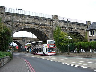
Slateford is a suburb of Edinburgh, the capital of Scotland. It is east of the Water of Leith.

Stenhouse is a suburb of Edinburgh, the capital of Scotland. It lies to the west of the City Centre, adjacent to Whitson and Saughton Mains and close to Broomhouse and Chesser. It is a mainly residential area.

Warriston is a suburb of Edinburgh, the capital of Scotland. It lies east of the Royal Botanic Garden in Inverleith. The name derives from Warriston House, a local mansion house demolished in 1966.

The Oxgangs tower blocks were a group of 3 tower blocks which were built on Firrhill Drive/Oxgangs Crescent in 1961. They each contained a mixture of flats and maisonettes with 2 bedrooms each, totalling up to 80 homes per block. The blocks were called "Allermuir Court" "Caerketton Court" and "Capelaw Court" and were named after three of the nearby Pentland Hills
Balerno High School is a six-year secondary school located in Balerno, a suburb of Edinburgh, Scotland. The school stands on the banks of the Water of Leith, and serves children from Balerno, Kirknewton and Ratho, and also hosts pupils from a variety of areas outside the catchment area such as Currie, East Calder, Mid Calder, Edinburgh and Livingston.