Pentland Hills

Last updated

Pentland Hills
Pentland Hills From Caerketton Hill II.jpg
The Pentland Hills seen from Caerketton Hill
Highest point
Peak Scald Law
Elevation 579 m (1,900 ft)
Prominence 312
Coordinates 55°48.5′N03°22.5′W / 55.8083°N 3.3750°W / 55.8083; -3.3750
Dimensions
Length32 km (20 mi)
Geography
Edinburgh UK relief location map.jpg
Red triangle with thick white border.svg
Pentland Hills
Midlothian UK relief location map.jpg
Red triangle with thick white border.svg
Pentland Hills
Location in Midlothian
Scottish Borders UK relief location map.jpg
Red triangle with thick white border.svg
Pentland Hills
Location in Scottish Borders
Scotland relief location map.jpg
Red triangle with thick white border.svg
Pentland Hills
Location in Scotland
Country United Kingdom
Region Scotland

The Pentland Hills are a range of hills southwest of Edinburgh, Scotland. The range is around twenty miles (thirty kilometres) in length, and runs southwest from Edinburgh towards Biggar and the upper Clydesdale.

Contents

Etymology

The name is first recorded for the farm of Pentland (c. 1050, 1200) and probably derives from Brythonic elements pen and llan, meaning the Llan at the top or head of the hills. In the late 15th to mid-16th centuries, land transfers refer to Pentlandmure and Pentland – documents that also list adjacent parcels of land with such still-recognisable names as Loganehous, Hilend, Boghall and Mortounhall. 'Muir', in Pentlandmure, describes common grazings where the farm's livestock would be pastured in summer; and gradually the name was linked more specifically with the slopes of the nearby hills (perhaps Allermuir, Woodhouselee or Castlelaw). [1] The name is completely unrelated to the name of the Pentland Firth in the north of Scotland.

Timothy Pont mapped the area in the 1590s, and his work appeared in the maps of the Dutch cartographers Hondius (1630s) and Joan Blaeu (1654). Interestingly, Blaeu gives the name in two forms, in two different locations: Pentland Hill (roughly in the area of Castlelaw); and Penth-landt hill (further south and clearly intended as a name for the wider range).

Geology

The southern and western parts of the Pentland Hills are formed from sandstones together with some conglomerates, all of Devonian age and assigned to the Old Red Sandstone. Within the sedimentary sequence are extrusive igneous rocks, principally of basaltic and andesitic composition. The sedimentary rocks are also intruded by dykes of porphyrite.

The oldest rocks are a sequence of Silurian mudstones, siltstones and sandstones collected together as the North Esk Group. From oldest to youngest they comprise the Llandovery age Reservoir Formation (named for North Esk Reservoir where these rocks are to be found), the Deerhope Formation, the Cock Rig Formation and the Wether Law Linn Formation overlain by the Wenlockian age Henshaw Formation. These are in turn unconformably overlain by the late Silurian to early Devonian age sandstones and conglomerates of the Greywacke Conglomerate and Swanshaw Sandstone formations. A further unconformity separates these from the overlying Pentland Hills Volcanic Formation though all three formations are collected together within the Lanark Group. The Volcanic Formation forms such summits as East and West Kip.

The southeastern edge of the range is defined by the Pentland Fault with a substantial downthrow to the southeast. Running NE-SW through the middle of the range is the Cairnmuir Fault which downthrows to the northwest. West Cairn Hill and East Cairn Hill are formed by the sandstones of the Kinnesswood Formation which reach as far north as Hare Hill (though also underlie much of the southeastern part of Edinburgh) and which terminate to the southeast at the Cairnmuir Fault. The Kinnesswood sandstones together with rocks of the Ballaggan Formation, which form the lower ground immediately northwest of the Pentlands, constitute the early Carboniferous age Inverclyde Group.

Black Hill stands out as being an intrusion of microgranite or felsite, as in part is nearby Harbour Hill. South Black Hill on the other hand, together with Scald Hill and Carnethy hill are formed from various lithologies of the Pentland Hills Volcanic Formation, as too are Allermuir, Caerketton and Castlelaw hills. The Volcanic Formation gives rise to generally steeper and craggier hillsides as these rocks are more resistant to erosion than the sedimentary rocks.

Much of the lower ground is covered by glacial till from the last ice age. Glacial meltwater channels are identified in places as at Deer Hope and the deep cleft of Green Cleugh between Hare Hill and Black Hill. [2] [3] [4]

List of peaks

The peaks include:

The hills span a number of council regions: from the City of Edinburgh council area and Midlothian in the north, south-west through West Lothian to the Scottish Borders and South Lanarkshire.

Use

The Pentland Hills Regional Park was designated in 1986. [5] It covers an area of 90 km2 (35 sq mi) at the northern end of the hills. The park, together with the rest of the hills, is used for a variety of recreational activities including hillwalking, mountain biking, horse riding, golf, and skiing at the artificial ski slope at the Midlothian Snowsports Centre.

Today most of the land is upland pasture, along with a few forestry plantations. The Ministry of Defence have a rifle range at Castlelaw. A number of rivers rise in the hills, including the Water of Leith and the North Esk, and there are several reservoirs, including Threipmuir, Harlaw, Clubbiedean, Torduff, Glencorse and Loganlea.

In the southern part of the hills is Little Sparta, the garden of the late artist and poet Ian Hamilton Finlay.

Settlements in or near the Pentlands include:

History

The Covananter's Grave The Covananters Grave (geograph 2119494).jpg
The Covananter's Grave

There is evidence of prehistoric settlement in the area, e.g. the hillfort and souterrain at Castle Law, [6] and another at Caerketton. The hills were most likely settled, farmed and defended in the pre-Roman and Roman era by the local Celtic people known to the Romans as the Votadini. [7]

About 20 m (66 ft) into Glencorse Reservoir lie the submerged ruins of the chapel of St Katherine's in the Hope. The founding of the chapel is connected with the story of a mediaeval royal deer hunt. According to the story, King Robert the Bruce staked the Pentland Estate against the life of Sir William St Clair, with the outcome of the hunt of a white deer by the knight and his two hounds, 'Help' and 'Hold', being the deciding factor. The dogs managed to bring down the deer, and in gratitude, and to mark the spot, Sir William had a chapel built in the glen.

The hills were the scene of an incident in 1666 following the Restoration of King Charles II when an outbreak of armed rebellion amongst Covenanters led to a small force of badly armed conventiclers being defeated at the battle of Rullion Green. Afterwards the whole episode was (incorrectly) named the Pentland Rising. The incident is commemorated by the "Covenanter's Grave", a cairn after which one of the drove roads across the hills is known (OS Grid Reference NT078521).

In literature

In Greyfriars Bobby, Bobby comes from (and later revisits) the Pentland Hills, whilst in Mary Shelley's novel Frankenstein , Frankenstein's friend Henri Clerval is said to have been filled with 'cheerfulness and admiration' when he visited the Pentland Hills while heading further north (Chapter 19).

See also

Related Research Articles

<span class="mw-page-title-main">Midlothian</span> Council area of Scotland

Midlothian is a historic county, registration county, lieutenancy area and one of 32 council areas of Scotland used for local government. Midlothian lies in the east-central Lowlands, bordering the City of Edinburgh council area, East Lothian and the Scottish Borders.

<span class="mw-page-title-main">West Lothian</span> Council area of Scotland

West Lothian is one of the 32 council areas of Scotland, and was one of its historic counties. The county was called Linlithgowshire until 1925. The historic county was bounded geographically by the Avon to the west and the Almond to the east. The modern council area occupies a larger area than the historic county. It was reshaped following local government reforms in 1975: some areas in the west were transferred to Falkirk; some areas in the east were transferred to Edinburgh; and some areas that had formerly been part of Midlothian were added to West Lothian.

<span class="mw-page-title-main">Dumfriesshire</span> Historic county in Scotland

Dumfriesshire or the County of Dumfries or Shire of Dumfries is a historic county and registration county in southern Scotland. The Dumfries lieutenancy area covers a similar area to the historic county.

<span class="mw-page-title-main">Great Dodd</span> Mountain in the English Lake District, Cumbria, England

Great Dodd is a mountain or fell in the English Lake District. It stands on the main ridge of the Helvellyn range, a line of mountains which runs in a north–south direction between the lakes of Thirlmere and Ullswater in the east of the Lake District. Great Dodd, with a height of 857 metres (2,812 ft) is the highest of the fells in this range to the north of Sticks Pass.

<span class="mw-page-title-main">Penicuik</span> Town in Midlothian, Scotland

Penicuik is a town and former burgh in Midlothian, Scotland, lying on the west bank of the River North Esk. It lies on the A701 midway between Edinburgh and Peebles, east of the Pentland Hills.

<span class="mw-page-title-main">Southern Uplands</span> Southernmost and least populous region of Scotland

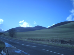
The Southern Uplands are the southernmost and least populous of mainland Scotland's three major geographic areas. The term is used both to describe the geographical region and to collectively denote the various ranges of hills and mountains within this region. An overwhelmingly rural and agricultural region, the Southern Uplands are partly forested and contain many areas of open moorland - the hill names in the area are congruent with these characteristics.

<span class="mw-page-title-main">River Esk, Lothian</span> River in Midlothian and East Lothian, Scotland

The River Esk, also called the Lothian Esk, is a river that flows through Midlothian and East Lothian, Scotland.

<span class="mw-page-title-main">A702 road</span> Road in Scotland

The A702 is a major road in Scotland, that runs from Edinburgh to St. John's Town of Dalry in Dumfries and Galloway. It is the last section of the route from London via the West Midlands and North West England to Edinburgh, which follows the M1, M6, A74(M) and finally the A702.

<span class="mw-page-title-main">Lasswade</span> Human settlement in Scotland

Lasswade is a village and civil parish in Midlothian, Scotland, on the River North Esk, nine miles south of Edinburgh city centre, contiguous with Bonnyrigg and between Dalkeith to the east and Loanhead to the west. Melville Castle lies to the north east. The Gaelic form is Leas Bhaid, meaning the "clump at the fort."
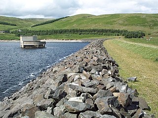
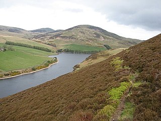
<span class="mw-page-title-main">Lomond Hills</span> Range of hills in central Scotland

The Lomond Hills, also known outside the locality as the Paps of Fife, are a range of hills in central Scotland. They lie in western central Fife and Perth and Kinross, Scotland. At 522 metres (1,713 ft) West Lomond is the highest point in the county of Fife.
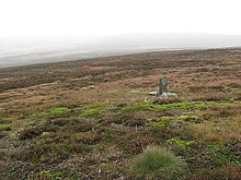
<span class="mw-page-title-main">Gladhouse Reservoir</span> Reservoir in Midlothian

Gladhouse Reservoir, formerly known as Moorfoot Loch, is a reservoir in Midlothian, Scotland, five miles (8 km) south of Penicuik. It is the most southerly reservoir in Midlothian, as well as being the largest area of freshwater in the Lothians. It is used to supply Edinburgh with drinking water.

<span class="mw-page-title-main">Moorfoot Hills</span>

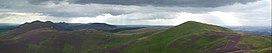
The Moorfoot Hills are a range of hills south of Edinburgh in east central Scotland, one of the ranges which collectively form the Southern Uplands.

<span class="mw-page-title-main">Glencorse Reservoir</span> Reservoir in Midlothian, Scotland

Glencorse Reservoir is a reservoir in Midlothian, Scotland, two miles west of Glencorse, in the Pentland Hills.

<span class="mw-page-title-main">Edgelaw Reservoir</span> Reservoir in Midlothian, Scotland

Edgelaw Reservoir is an artificial reservoir in Midlothian, Scotland, UK, four miles west of Temple.

<span class="mw-page-title-main">Glencorse Barracks</span>

Glencorse Barracks is a British Army barracks situated in Glencorse just outside the town of Penicuik in Midlothian, Scotland. It is one of the three barracks which make up the City of Edinburgh Garrison, with Dreghorn and Redford Barracks. It has been the home for The Royal Highland Fusiliers, 2nd Battalion, The Royal Regiment of Scotland since 2006.

Glencorse is a parish of Midlothian, Scotland, lying 7 miles south of Edinburgh. It is bounded on the north-west by the former parish of Colinton now within the City of Edinburgh, to the north and west by Lasswade and to the south and west by Penicuik.

The Lanark Group is a late Silurian to early Devonian lithostratigraphic group in southern Scotland. The name is derived from the town of Lanark. It consists of sandstones and conglomerates within the Greywacke Conglomerate and Swanshaw Sandstone formations together with a wide range of igneous lithologies within the overlying Pentland Hills Volcanic Formation. The group is itself a division of the Old Red Sandstone Supergroup.

<span class="mw-page-title-main">West Cairn Hill</span>

West Cairn Hill is a hill in the Pentland Hills range of Scotland. With a height of 562 m (1,844 ft), it is the fifth highest elevation and lies on the western flank of the approximately 20 mi (32 km) long chain of hills.

<span class="mw-page-title-main">Caerketton Hill</span>

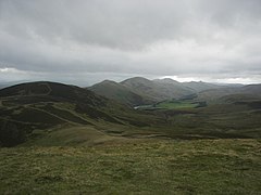
Caerketton Hill is a hill in the Pentland Hills range of Scotland. Standing at 478 m, it is at the northeast end of the approximately 25 km (16 mi) long chain of hills on the border between the City of Edinburgh council area and Midlothian. The nearest settlements are Currie, three miles to the west, and Loanhead, four miles to the east. Edinburgh's southern boroughs start about two kilometers north. The nearest hills are Allermuir Hill to the west and Woodhouselee Hill to the south. The Boghall Burn rises on the southern flank and eventually drains into the Firth of Forth via North Esk and Esk.

References

  1. Baldwin, John and Drummond, Peter (2011) Pentland Place-Names. An Introductory Guide. Pub. by The Friends of the Pentlands, Edinburgh
  2. "Scotland Sheet 32E Edinburgh Bedrock". Maps Portal. British Geological Survey. Retrieved 17 June 2020.
  3. "Scotland Sheet 32W Livingston Bedrock". Maps Portal. British Geological Survey. Retrieved 17 June 2020.
  4. "Scotland Sheet 24W Biggar Solid". Maps Portal. British Geological Survey. Retrieved 17 June 2020.
  5. Falconer, Susan (2007). The Pentland Hills: A Walker's Guide. Cicerone Press. p. 9. ISBN   978-1-85284-494-3.
  6. "Site Record for Castle Law, Glencorse CastlelawDetails Details". Canmore.rcahms.gov.uk. Retrieved 16 March 2014.
  7. "An Introduction - Pentland Hills Regional Park". The Pentland Hills. 15 November 2010. Retrieved 16 March 2014.