
The Water of Leith is the main river flowing near central Edinburgh, Scotland, and flows into the port of Leith where it flows into the sea via the Firth of Forth.

Ladybower Reservoir is a large Y-shaped reservoir, the lowest of three in the Upper Derwent Valley in Derbyshire, England. The River Ashop flows into the reservoir from the west; the River Derwent flows south, initially through Howden Reservoir, then Derwent Reservoir, and finally through Ladybower Reservoir.

A spillway is a structure used to provide the controlled release of water from a dam or levee downstream, typically into the riverbed of the dammed river itself. In the United Kingdom, they may be known as overflow channels. Spillways ensure that water does not damage parts of the structure not designed to convey water.
The Banqiao Reservoir Dam is a dam on the River Ru (汝河), a tributary of the Hong River in Zhumadian City, Henan province, China. The Banqiao dam and Shimantan Reservoir Dam are among 62 dams in Zhumadian that failed catastrophically in 1975 during Typhoon Nina. The dam was subsequently rebuilt.

The Water of Leith, is a small river in the South Island of New Zealand.

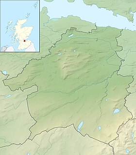
The Pentland Hills are a range of hills to the south-west of Edinburgh, Scotland. The range is around 20 miles (32 km) in length, and runs south west from Edinburgh towards Biggar and the upper Clydesdale.
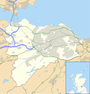
Balerno is a village on the outskirts of Edinburgh, Scotland situated 8 miles south-west of the city centre, next to Currie and then Juniper Green. Traditionally in the county of Midlothian it now administratively falls within the jurisdiction of the City of Edinburgh Council.

A reservoir is most commonly an enlarged natural or artificial lake created using a dam to store water.

The Blowering Dam is a major ungated rock fill with clay core embankment dam with concrete chute spillway impounding a reservoir under the same name. It is located on the Tumut River upstream of Tumut in the Snowy Mountains region of New South Wales, Australia. Purposes for the dam include flood mitigation, hydro-power, irrigation, water supply and conservation. The dam is part of the Snowy Mountains Scheme, a vast hydroelectricity and irrigation complex constructed in south-east Australia between 1949 and 1974 and now run by Snowy Hydro.
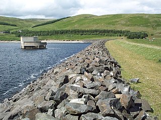
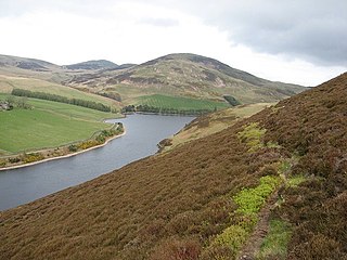
Megget Reservoir is an impounding reservoir in the Megget valley in Ettrick Forest, in the Scottish Borders. The 259 hectares reservoir is held back by the largest earth dam in Scotland. The reservoir collects water from the Tweedsmuir Hills, which is then conveyed 28 miles (45 km) via underground pipelines and tunnels to Edinburgh. The pipelines are routed through the Manor Valley and the Meldon Hills, to Gladhouse Reservoir and Glencorse Reservoir in the Pentland Hills. These two reservoirs store the water until such times as it is required. Excess water which overflows from the reservoir is returned to the Megget Water, and hence into St. Mary's Loch.
Alnwickhill is a suburb of Edinburgh, the capital of Scotland. It is on the southern edge of the city, approximately 4 miles (6.4 km) from the city centre. It neighbours the areas of Liberton and Kaimes.

The Talla Railway was a privately constructed railway line in southern Scotland. It was built in 1895 - 1897 to aid the construction of the Talla Reservoir, to serve the water demand of Edinburgh. The railway was about eight miles (13 km) long, running south from a connection with the Caledonian Railway's Peebles branch at Broughton. A private passenger service was operated for workmen on the reservoir construction.
Harperrig Reservoir is a reservoir in West Lothian, Scotland, to the north of the Pentland Hills, four miles (6.4 km) south of Mid Calder. The Water of Leith flows through it, and nearby are Harlaw Reservoir and Threipmuir Reservoir. It has been proposed that the reservoir be designated as a local nature reserve to be managed by West Lothian Council.
Harlaw Reservoir is a small reservoir in the City of Edinburgh Council area, Scotland, UK, situated at the base of the Pentland Hills near Currie and Balerno.
Glencorse Reservoir is a reservoir in Midlothian, Scotland, UK, two miles west of Glencorse, in the Pentland Hills.

James Jardine was a Scottish civil engineer, mathematician and geologist. He was the first person to determine mean sea level. He built tunnels and bridges, including for the Innocent Railway, and built reservoirs including Glencorse, Threipmuir, Harlaw for Edinburgh Water Company, and Cobbinshaw for the Union Canal.

The Braid Burn is a burn or stream 14 kilometres (8.7 mi) in length that flows through south and east Edinburgh.
The Hantangang Dam is a gravity dam on the Hantan River in Yeoncheon County, Gyeonggi Province, South Korea. Construction on the dam began in 2007 and completed in 2015. The primary purpose of the dam is flood control : it was proposed in 1998 after a series of floods in the late 1990s that killed 128 people, displaced over 31,000 and caused about US$900 million in property damage. Initially designed as a multi-purpose project, the design was changed solely to flood control in 2006 due to the concerns of residents upstream. It is being implemented by Korea Water Resources Corporation (K-water).
James Leslie FRSE was a Scottish civil engineer specialising in docks, harbours bridges and reservoirs, largely on the east coast of Scotland. He was also an amateur meteorologist.
Edinburgh Water Company and its successors have provided a public water supply and latterly sewerage and sewage treatment services to the Scottish Capital of Edinburgh. The original company was established in 1819 to supply drinking water. It did so until 1870, when it was taken over by a public Water Trust, with representatives from Edinburgh, Leith and Portobello. That in turn was taken over by Edinburgh Corporation and in 1975, responsibility passed to the Lothian Regional Council, as did the duty to provide sewerage and sewage treatment services. Both services were moved out of local authority control, and taken over by the East of Scotland Water Authority in 1996. The three Scottish regional water authorities were merged to form Scottish Water in 2002.

