Hills in Edinburgh

Last updated

Salisbury Crags, with Arthur's Seat behind Panorama SalisburyCrags.jpg
Salisbury Crags, with Arthur's Seat behind

Edinburgh, the capital of Scotland, is traditionally said to have been "built on Seven Hills", in an allusion to the seven hills of Rome. While there is considerable room for debate as to which hills are included and excluded from the seven, seven possibilities are listed in an old rhyme: [1] [poem 1]

Contents

The Pentland Hills are also just to the south of the city, and their lower slopes are within the city boundary, especially around Hillend, Swanston and Balerno. Some of the hills are formed from dead volcanoes that last erupted 400 million years ago, [2] and all show the effect of glaciation.

The tale of the seven hills of Edinburgh is popular enough that several local business take their name from it, including a dentist, [3] a tour company, [4] and a cèilidh band. [5]

Traditional Seven

The Castle Rock, perhaps Edinburgh's best known hill Edinburgh-pano2s.jpg
The Castle Rock, perhaps Edinburgh's best known hill

There is some argument as to which the seven are. Arthur's Seat and the Braid Hills, for example, are ranges of hill, containing several summits, rather than just one. In total, there are ten summits with a prominence of at least 30 metres (98 ft).

A running race, held yearly since 1980, takes in these seven hills, starting and finishing at Calton Hill (although it actually excludes Wester Craiglockhart because it is private property, and instead includes the lower Easter Craiglockhart). [6]

Debate over 'The Seven'

The Royal Observatory atop Blackford Hill Royal Observatory Edinburgh on Blackford Hill-Oct2005.jpg
The Royal Observatory atop Blackford Hill

Before the construction of the New Town, Edinburgh was built on a single hill, the volcanic Castle Rock and its tail that extended to the east. The building of the New Town and subsequent development in the 19th and 20th centuries saw first Calton Hill and later all of the others listed above being absorbed into the city, and the "traditional seven" have some claim to being described as the seven principal hills within the modern boundaries of Edinburgh.

There are many other hills in Edinburgh, some part of the above ranges, or simply hidden beneath housing etc. There are for example, ridges extending from Dalry and Ardmillan, and also Sighthill. Craigmillar Castle is also on top of a small hill, and there is another small one underneath Colinton. There are also hills beneath the New Town, and the Old Town to the south of the Cowgate. Some of these hills rise to heights substantially above the traditional seven — for example parts of Fairmilehead at 183 metres (600 ft).

The Pentland Hills to the south of Edinburgh are traditionally thought of as being outside the city, although they are very close, and because of their height they dominate views to the south of the city. Allermuir Hill at 493m is only slightly further from the centre of Edinburgh than Corstorphine Hill, and is almost twice the height of Arthur's Seat.

A number of Edinburgh suburbs, also contain "hill" or synonyms in their name — Abbeyhill, Alnwickhill, Church Hill, Curriehill, Drylaw (Lowland Scots for a "hill without a spring"), Ferniehill, Firrhill, Greenhill, Piershill, Sighthill; and others also contain the element "Craig" meaning a large rock, such as Craigentinny and Craigmillar.

Hills in the centre of the city

The Governor's House on Calton Hill ViewTowardsCaltonHill.JPG
The Governor's House on Calton Hill

Edinburgh is also traditionally thought of as being a hilly city, because of the number of hills in or close to the city centre. Chief among these is the Royal Mile which rises continuously from Holyrood House to Edinburgh Castle for approximately a mile. Others include -

The many height changes have led to several roads crossing other roads on bridges, which was relatively rare in pre-20th century Britain. These include Waterloo Place above Calton Road, George IV Bridge over the Cowgate and Merchant Street, South Bridge over the Cowgate, and King's Bridge carrying Johnston Terrace over Kings Stables Road. There are also several staircases accessible to pedestrians only, linking streets at different heights, including Playfair Steps between Market Street and Princes Street, Jacob's Ladder between Calton Road and Regent Road, and the News Steps, between St Giles Street and Market Street.

Outlying hills include the climb from Tollcross to Bruntsfield and beyond Morningside to Fairmilehead, and Liberton Brae.

Related Research Articles

<span class="mw-page-title-main">Midlothian</span> Council area of Scotland

Midlothian is an historic county, registration county, lieutenancy area and one of 32 council areas of Scotland used for local government. Midlothian lies in the east-central Lowlands, bordering the City of Edinburgh council area, East Lothian and the Scottish Borders.

<span class="mw-page-title-main">Thomas Hamilton (architect)</span> Scottish architect (1784-1858)

Thomas Hamilton was a Scottish architect, based in Edinburgh where he designed many of that city's prominent buildings. Born in Glasgow, his works include: the Burns Monument in Alloway; the Royal High School on the south side of Calton Hill ; the Royal College of Physicians of Edinburgh; the George IV Bridge, which spans the Cowgate; the Dean Orphan Hospital, now the Dean Gallery; the New North Road Free Church, now the Bedlam Theatre; Cumstoun, a private house in Dumfries and Galloway; and the Scottish Political Martyrs' Monument in Old Calton Cemetery, Edinburgh.

<span class="mw-page-title-main">Calton Hill</span> Hill in central Edinburgh, Scotland

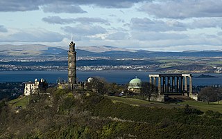
Calton Hill is a hill in central Edinburgh, Scotland, situated beyond the east end of Princes Street and included in the city's UNESCO World Heritage Site. Views of, and from, the hill are often used in photographs and paintings of the city.

<span class="mw-page-title-main">Cowgate</span> Street in Edinburgh, Scotland, UK

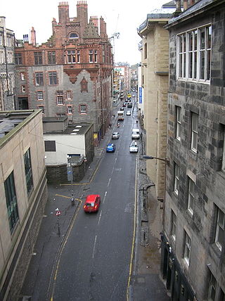
The Cowgate is a street in Edinburgh, Scotland, located about 550 yards (500 m) southeast of Edinburgh Castle, within the city's World Heritage Site. The street is part of the lower level of Edinburgh's Old Town, which lies below the elevated streets of South Bridge and George IV Bridge. It meets the Grassmarket at its west end and Holyrood Road to the east.

<span class="mw-page-title-main">Edinburgh East (UK Parliament constituency)</span> Parliamentary constituency in the United Kingdom, 2005 onwards

Edinburgh East is a burgh constituency of the House of Commons of the Parliament of the United Kingdom. It elects one Member of Parliament (MP) by the first past the post system of election.

<span class="mw-page-title-main">Edinburgh South (Scottish Parliament constituency)</span> Scottish Parliament constituency

Edinburgh South was a constituency of the Scottish Parliament (Holyrood). It elected one Member of the Scottish Parliament (MSP) by the plurality method of election. Also, however, it was one of nine constituencies in the Lothians electoral region, which elected seven additional members, in addition to nine constituency MSPs, to produce a form of proportional representation for the region as a whole.

<span class="mw-page-title-main">Craiglockhart</span>

Craiglockhart is a suburb in the south west of Edinburgh, Scotland, lying between Colinton to the south, Morningside to the east Merchiston to the north east, and Longstone and Kingsknowe to the west. The Water of Leith is also to the west.

<span class="mw-page-title-main">Timeline of Edinburgh history</span> Timeline of history in Edinburgh, Scotland

This article is a timeline of the history of Edinburgh, Scotland, up to the present day. It traces its rise from an early hill fort and later royal residence to the bustling city and capital of Scotland that it is today.

<span class="mw-page-title-main">Edinburgh Central (Scottish Parliament constituency)</span> Burgh constituency of the Scottish Parliament

Edinburgh Central is a burgh constituency of the Scottish Parliament (Holyrood) covering part of the council area of Edinburgh. It elects one Member of the Scottish Parliament (MSP) by the plurality method of election. It is also one of nine constituencies in the Lothian electoral region, which elects seven additional members, in addition to the nine constituency MSPs, to produce a form of proportional representation for the region as a whole.

Sighthill is a suburb in the west of Edinburgh, Scotland. The area is bordered by Broomhouse and Parkhead to the east, South Gyle to the north, the industrial suburb of Bankhead and the Calders neighbourhood to the west, and Wester Hailes to the south. It is sometimes included in the Wester Hailes area, while the Calders, Bankhead and Parkhead are sometimes considered parts of Sighthill. Administratively it has formed a core part of the City of Edinburgh Council's Sighthill/Gorgie ward since 2007.

<span class="mw-page-title-main">Longstone, Edinburgh</span> Human settlement in Scotland

Longstone is a suburb of Edinburgh in Scotland. The area is primarily residential in nature, although the area includes several small shops, eateries and supermarkets, as well as one of the main bus depots for the city's buses. The population of Longstone was 4,678 in 2019.

<span class="mw-page-title-main">The Calders</span>

The Calders is a residential neighbourhood in Edinburgh, Scotland – not to be confused with the Calders of West Lothian aka West Calder, Mid Calder and East Calder, three separate villages. It is sometimes considered to be part of Wester Hailes or Sighthill, larger developments to its south and east respectively. From 2007 to 2017, it fell within the Sighthill/Gorgie multi-member ward of the City of Edinburgh Council administration along with Sighthill, but following a boundary change has been in the Pentland Hills ward since then, along with Wester Hailes.

<span class="mw-page-title-main">Corstorphine Hill</span>

Corstorphine Hill is a low ridge-shaped hill rising above the western suburbs of Edinburgh, Scotland. Although there has been residential and commercial development on its lower slopes, especially in the south and west, most of the hill is occupied by a local nature reserve, consisting of extensive broadleaf woodland, accessible to the public.

<span class="mw-page-title-main">Regent Bridge</span> Arch bridge in Edinburgh, Scotland, UK

Regent Bridge is a road bridge in Edinburgh, Scotland, where the A1 road enters the New Town from the east and passes over a hollow near Calton Hill. The bridge was built in the 19th century, in the neoclassical style as the medieval city was modernised and expanded to the north and east.

<span class="mw-page-title-main">Leith Central railway station</span> Former railway station in Leith, Scotland

Leith Central Railway Station was a railway station in Leith, Scotland. It formed the terminus of a North British Railway branch line from Edinburgh Waverley. The station was built on a large scale, and it included a trainshed over the platforms.

<span class="mw-page-title-main">Edinburgh town walls</span> City walls in City of Edinburgh, Scotland, UK

There have been several town walls around Edinburgh, Scotland, since the 12th century. Some form of wall probably existed from the foundation of the royal burgh in around 1125, though the first building is recorded in the mid-15th century, when the King's Wall was constructed. In the 16th century the more extensive Flodden Wall was erected, following the Scots' defeat at the Battle of Flodden in 1513. This was extended by the Telfer Wall in the early 17th century. The walls had a number of gates, known as ports, the most important being the Netherbow Port, which stood halfway down the Royal Mile. This gave access from the Canongate which was, at that time, a separate burgh.

<span class="mw-page-title-main">City of Edinburgh Council</span> Local government body in Scotland

The City of Edinburgh Council is the local government authority covering the City of Edinburgh council area. The majority of the council area is the area of Edinburgh, capital of Scotland. With a population of 518,500 in mid-2019, it is the second most populous local authority area in Scotland.

<span class="mw-page-title-main">Outline of Edinburgh</span> Overview of and topical guide to Edinburgh

The following outline is provided as an overview of and topical guide to Edinburgh:

<span class="mw-page-title-main">Edinburgh the Walk</span> Edinburgh guidebook detailing long distance walk route around city

References

  1. Malinowski, Gościwit (June 2017). "Septimontium (Seven Hills) as conditio sine qua non for a City to Pretend to be a Capital" (PDF). Horizons: Seoul Journal of Humanities. Institute of Humanities, Seoul National University. 8 (1): 3–26.[ dead link ]
  2. Irshad, Wahid; Goh, Keng; Kubie, Jorge (September 2009). "Wind resource assessment in the Edinburgh region". 2009 World Non-Grid-Connected Wind Power and Energy Conference. Nanjing, China: IEEE. pp. 1–5. doi:10.1109/WNWEC.2009.5335836. ISBN   978-1-4244-4702-2. S2CID   24929016.
  3. "Seven Hills Dental Practice". sevenhillsdental.co.uk. Retrieved 29 December 2019.
  4. "Seven Hills Tours". 7hillstours.co.uk. Retrieved 29 December 2019.
  5. "Seven Hills Ceildh Band". 7hillsceilidh.com. Retrieved 29 December 2019.
  6. "Seven Hills of Edinburgh Race & Challenge: The Course". Seven-Hills.org.uk. Retrieved 28 March 2013.

The poem

  1. Abbey, Calton, Castle grand,
    Southward see St Leonards stand,
    St Johns and Sciennes as two are given,
    And Multrees makes Seven.