Upland pasture

Last updated
J. Alden Weir 1905 painting "Upland Pasture" Upland Pasture.JPG
J. Alden Weir 1905 painting "Upland Pasture"

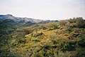
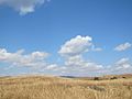
Upland pasture (rough grazing and/or semi-natural rough grazing) is a type of semi-natural grassland located in uplands of rolling foothills or upon higher slopes, greater than 350 meters (1148.29 feet) and less than 600 meters (1968.50 feet) from ground level, that is used primarily for grazing. [1] Upland pastures occur in most grassland systems where topographic slope prevents feasible crop production; they are a primary component of rangelands, but are not necessarily water limited. Upland pastures include highlands, moorland, and other grasslands in regions of upland soils (said to have the potential for hydric inclusions, rather than definitive hydric inclusion; meaning there is potential for "saturation, flooding, or ponding long enough during the growing season to develop anaerobic conditions"). [2] [3]

Contents

Locations

The term originates in the British Isles where upland pastures constitute approximately 9 million hectares, 48% of agricultural land use in the UK. [1] Upland pastures are widely managed in the United States in New England and Appalachia, and in semi-arid mountain regions in the inter-mountain west where their management is an important aspect of historic farming, wildlife preservation, and range livestock production. [4] [5] [6] Upland pastures are also of primary importance to livestock production in western Australia, [7] the Mongolian-Manchurian grassland ecoregion, [8] in the Andes of Argentina, Uruguay, Paraguay, and western Brazil, in the Eurasian Steppes, in South Africa's Highveld, in Switzerland and the Alps, Sweden, Iceland, India, Juniper grasslands around Jabal Sawda in Saudi Arabia and other Juniper encroached grasslands in the Middle East including in Jordan, Israel, Turkey, Kazakhstan, as well as in eastern European nations, and, Tibet, New Zealand, Ethiopia, Canada, Kenya, Tanzania, Eritrea, Yemen, Ghana, Nigeria, Papua New Guinea, Syria, and Cantabria. [9] [10]

See also

Sources

  1. 1 2 Davies, A.; Fothergill, M.; Jones, J.R. (1998). "Efficient Use of Upland Pasture" (PDF). IGER Innovations: 59–63. Retrieved 21 September 2018.
  2. "Hydric soils definition". United States Department of Agriculture: Natural Resources Conservation Service Caribbean Area. Retrieved 21 September 2018.
  3. Beall, Barbra B. "Wetland FAQs". New York State Wetland Forum. Retrieved 21 September 2018.
  4. Mires, Peter B. (December 1993). "The importance of aspect to historic farmstead site location in the green mountains of Vermont". Historical Archaeology. 27 (4): 82–91. doi:10.1007/bf03373575. ISSN   0440-9213.
  5. Jurney, D. H.; Stahle, D. W. (2004). "Old-growth wooded pasture in the Ozarks". Gen. Tech. Rep. SRS-73: 42–52.
  6. Clary, Warren P.; Webster, Bert F. (1989). "Managing grazing of riparian areas in the Intermountain Region". Gen. Tech. Rep. INT-263. 11: 263.
  7. "Mitchell grass upland pastures of the Kimberley". Department of Primary Industries and Regional Development, Western Australia. 2018. Retrieved 21 September 2018.
  8. Carpenter, Chris. "Mongolian-Manchurian grassland". Washington, DC: World Wildlife Fund. Retrieved 21 September 2018.
  9. Dotson, Brandon (2009). Contemporary visions in Tibetan studies: proceedings of the First International Seminar of Young Tibetologists (1st ed.). Chicago: Serindia Publications. ISBN   9781932476453. OCLC   426147229.
  10. Ross, Mars; Cooper, H. Stonehewer (1885). The Highlands of Cantabria; or, Three days from England. London: Sampson Low, Marston, Searle, & Rivington. p. 491. Retrieved 21 September 2018.

Related Research Articles

<span class="mw-page-title-main">Geography of Mongolia</span>

Mongolia is a landlocked country in East Asia, located between China and Russia. The terrain is one of mountains and rolling plateaus, with a high degree of relief. The total land area of Mongolia is 1,564,116 square kilometres. Overall, the land slopes from the high Altai Mountains of the west and the north to plains and depressions in the east and the south. The Khüiten Peak in extreme western Mongolia on the Chinese border is the highest point. The lowest point is at 560 m (1,840 ft), is the Hoh Nuur or lake Huh. The country has an average elevation of 1,580 m (5,180 ft).

<span class="mw-page-title-main">Grassland</span> Area with vegetation dominated by grasses

A grassland is an area where the vegetation is dominated by grasses (Poaceae). However, sedge (Cyperaceae) and rush (Juncaceae) can also be found along with variable proportions of legumes, like clover, and other herbs. Grasslands occur naturally on all continents except Antarctica and are found in most ecoregions of the Earth. Furthermore, grasslands are one of the largest biomes on earth and dominate the landscape worldwide. There are different types of grasslands: natural grasslands, semi-natural grasslands, and agricultural grasslands. They cover 31–69% of the Earth's land area.

<span class="mw-page-title-main">Transhumance</span> Type of pastoralism

Transhumance is a type of pastoralism or nomadism, a seasonal movement of livestock between fixed summer and winter pastures. In montane regions, it implies movement between higher pastures in summer and lower valleys in winter. Herders have a permanent home, typically in valleys. Generally only the herds travel, with a certain number of people necessary to tend them, while the main population stays at the base. In contrast, horizontal transhumance is more susceptible to being disrupted by climatic, economic, or political change.

<span class="mw-page-title-main">Meadow</span> Open habitat vegetated primarily by non-woody plants

A meadow is an open habitat or field, vegetated by grasses, herbs, and other non-woody plants. Trees or shrubs may sparsely populate meadows, as long as these areas maintain an open character. Meadows can occur naturally under favourable conditions, but are often artificially created from cleared shrub or woodland for the production of hay, fodder, or livestock. Meadow habitats, as a group, are characterized as "semi-natural grasslands", meaning that they are largely composed of species native to the region, with only limited human intervention.

Highlands or uplands are areas of high elevation such as a mountainous region, elevated mountainous plateau or high hills. Generally, upland refers to a range of hills, typically from 300 m (980 ft) up to 500–600 m (1,600–2,000 ft), while highland is usually reserved for ranges of low mountains. However, the two terms are sometimes interchangeable.

<span class="mw-page-title-main">Grazing</span> Feeding livestock on forage

In agriculture, grazing is a method of animal husbandry whereby domestic livestock are allowed outdoors to roam around and consume wild vegetations in order to convert the otherwise indigestible cellulose within grass and other forages into meat, milk, wool and other animal products, often on land unsuitable for arable farming.

<span class="mw-page-title-main">Rangeland</span> Biomes which can be grazed by animals or livestock (grasslands, woodlands, prairies, etc)

Rangelands are grasslands, shrublands, woodlands, wetlands, and deserts that are grazed by domestic livestock or wild animals. Types of rangelands include tallgrass and shortgrass prairies, desert grasslands and shrublands, woodlands, savannas, chaparrals, steppes, and tundras. Rangelands do not include forests lacking grazable understory vegetation, barren desert, farmland, or land covered by solid rock, concrete and/or glaciers.

<span class="mw-page-title-main">Zud</span>

A zud, dzud of dzhut, zhut, djut, jut is a disaster in steppe, semi-desert and desert regions in Mongolia and Central Asia in which large numbers of livestock die, primarily due to starvation being unable to graze due to particular severe climatic conditions. Various kinds of zud are recognized, depending on the particular type of climatic conditions. In winter it may be caused by an impenetrable ice crust, in summer it may happen due to drought.

<span class="mw-page-title-main">Bale Mountains National Park</span> National park in Oromia Region, Ethiopia

Bale Mountains National Park (BMNP) is a national park in Ethiopia. The park encompasses an area of approximately 2,150 km2 (830 sq mi) in the Bale Mountains and Sanetti Plateau of the Ethiopian Highlands.

<span class="mw-page-title-main">Mongolian–Manchurian grassland</span> Ecoregion in East Asia

The Mongolian-Manchurian grassland, also known as the Mongolian-Manchurian steppe or Gobi-Manchurian steppe, in the temperate grassland biome, is an ecoregion in East Asia covering parts of Mongolia, the Chinese Autonomous region of Inner Mongolia, and Northeast China.

<span class="mw-page-title-main">New England–Acadian forests</span> Temperate broadleaf and mixed forest ecoregion of Canada and the United States

The New England-Acadian forests are a temperate broadleaf and mixed forest ecoregion in North America that includes a variety of habitats on the hills, mountains and plateaus of New England and New York State in the Northeastern United States, and Quebec and the Maritime Provinces of Eastern Canada.

<span class="mw-page-title-main">Conservation grazing</span> Use of animals to graze areas like nature reserves to maintain habitats

Conservation grazing or targeted grazing is the use of semi-feral or domesticated grazing livestock to maintain and increase the biodiversity of natural or semi-natural grasslands, heathlands, wood pasture, wetlands and many other habitats. Conservation grazing is generally less intensive than practices such as prescribed burning, but still needs to be managed to ensure that overgrazing does not occur. The practice has proven to be beneficial in moderation in restoring and maintaining grassland and heathland ecosystems. The optimal level of grazing will depend on the goal of conservation, and different levels of grazing, alongside other conservation practices, can be used to induce the desired results.

<span class="mw-page-title-main">Blue Mountains (ecoregion)</span> Temperate coniferous forests ecoregion of the United States

The Blue Mountains ecoregion is a Level III ecoregion designated by the United States Environmental Protection Agency (EPA) in the Pacific Northwest, mainly in the state of Oregon, with small areas over the state border in Idaho and southeastern Washington. It is also contiguous with the World Wildlife Fund's Blue Mountain forests ecoregion.

<span class="mw-page-title-main">Northern Basin and Range ecoregion</span>

The Northern Basin and Range ecoregion is a Level III ecoregion designated by the United States Environmental Protection Agency (EPA) in the U.S. states of Oregon, Idaho, Nevada, Utah, and California. It contains dissected lava plains, rolling hills, alluvial fans, valleys, and scattered mountain ranges in the northern part of the Great Basin. Although arid, the ecoregion is higher and cooler than the Snake River Plain to the north and has more available moisture and a cooler climate than the Central Basin and Range to the south. Its southern boundary is determined by the highest shoreline of Pleistocene Lake Bonneville, which once inundated the Central Basin and Range. The western part of the region is internally drained; its eastern stream network drains to the Snake River system.

<span class="mw-page-title-main">Ethiopian montane grasslands and woodlands</span>

The Ethiopian montane grasslands and woodlands is a montane grasslands and shrublands ecoregion in Ethiopia. It occupies the middle elevations of the Ethiopian Highlands, between the high-altitude Ethiopian montane moorlands and the lower-elevation Ethiopian montane forests.

<span class="mw-page-title-main">Canterbury–Otago tussock grasslands</span> Terrestrial ecoregion in New Zealand

The Canterbury-Otago tussock grasslands is an ecoregion of the South Island, New Zealand, part of the wider tussock grasslands of New Zealand.

<span class="mw-page-title-main">Land use in Wales</span> Overview of land management in Wales

Wales has a surface area of 20,779 km2 or 2,077,900 ha. It has a border with England to the east, and is bounded by the Irish Sea to the north and west, and by the Bristol Channel to the south. It has an oceanic temperate climate which is markedly influenced by the North Atlantic Current carrying warm water from tropical latitudes. As a result, it has a much milder climate than most places in the world at similar latitudes. Altitudes range from sea-level to 1085 m on the Snowdon Massif.

<span class="mw-page-title-main">Transhumance in Ethiopia</span> Type of pastoralism in the African nation

In the crop growing season, transhumance is practised on a broad scale in the northern Ethiopian highlands, as farmland and its stubble can no longer be accessed by livestock.

<span class="mw-page-title-main">Southland temperate forests</span> Terrestrial ecoregion in New Zealand

The Southland temperate forests is a temperate broadleaf and mixed forests ecoregion on New Zealand's South Island. The natural vegetation was mostly forest, but over the centuries human activities, including grazing and fires, replaced much of the original forest with grassland and agriculture.