Upland (mountain range)

Last updated
View of the Upland from the Niedersfelder Hochheide. The Hegekopf is in the centre. Hegekopf Hochheide.jpg
View of the Upland from the Niedersfelder Hochheide. The Hegekopf is in the centre.

The Upland (Low German for Oberland "highland") is a low mountain region forming the northeastern part of the High Sauerland and belongs the German state of Hesse, unlike the remainder of the High Sauerland which lies in Westphalia. The Upland falls within the district of Waldeck-Frankenberg, in North Hesse and corresponds to the territory of the municipality of Willingen.

Contents

Geography

The historic Upland lies in the southwestern area of the Diemelsee Nature Park at an average height of 500 to 700 m above NN. The northwestern and southwestern parts are almost entirely forested, whilst the centre, the area formally defined as a natural region called Upland (see below), only has islands of woods around some of the peaks.

Natural regions

The historic Upland lies predominantly in the northwestern Rothaar Mountains mountain range with smaller elements also in the East Sauerland foothills. It incorporates the natural region of Upland, as well as the (northeastern) half of the natural region of Langenberg, which contains the highest peak in the Rothaargebirge, the 843,1 m high Langenberg, as well as other summits over 800 m high.

The following natural regions lie wholly or partly (see brackets) in the historic Upland: [1]

Geology

The soils of the Upland are based mainly on Upper Devonian marl, argillaceous shale and calcareous sandstone. This combination has produced good soils for arable farming. As a result, the forests were cleared very early on and replaced by wood pasture (the East Sauerland "mountain heaths").

Mountains

February 2008 winter view of the Langenberg LangenbergBlickWinter.jpg
February 2008 winter view of the Langenberg

The highest mountain in the Upland is the Langenberg (843.2 m above  sea level (NN) ), which is located immediately next to the border with neighbouring North-Rhine-Westphalia (and just on the Westphalian side). The almost equally high Hegekopf (842.9 m) lies opposite and entirely on Hessian territory.

Since autumn 2002 the Ettelsberg (837.7 m) has had an observation platform on the Hochheideturm with a height of 875 m.

Amongst the mountains of the Upland (including all the "eight hundreds") are those in the following list. They are sorted by height in metres above Normalnull (NN) (natural regions in italics; mountains on the state border with North Rhine-Westphalia are asterisked (*)):

Rivers

The Rhine-Weser watershed runs through the Langenberg natural region, beyond the western perimeter of the historic Upland. East of this the majority of the rivers drain into the Diemel and flow in a north to northeasterly direction. They are, from west to east (source regions in brackets):

Through the Fore Upland Ridge (Vorupländer Rücken), in a west-southwest to east-northeast direction, runs the watershed between the Diemel and the Eder, south of which the Neerdar rises in the Inner Upland, whose upper reaches flow through the southeast of the historic Upland.

Towns and villages


Related Research Articles

Hochsauerlandkreis is a Kreis (district) in the east of North Rhine-Westphalia, Germany. Neighboring districts are Soest, Paderborn, Höxter, Waldeck-Frankenberg, Siegen-Wittgenstein, Olpe, Märkischer Kreis.

<span class="mw-page-title-main">Sauerland</span> Rural, hilly area in North Rhine-Westphalia, Germany

The Sauerland is a rural, hilly area spreading across most of the south-eastern part of North Rhine-Westphalia, in parts heavily forested and, apart from the major valleys, sparsely inhabited.

Waldeck-Frankenberg is a Kreis (district) in the north of Hesse, Germany. Neighbouring districts are Höxter, Kassel, Schwalm-Eder, Marburg-Biedenkopf, Siegen-Wittgenstein, Hochsauerland.

<span class="mw-page-title-main">Willingen</span> Municipality in Hesse, Germany

Willingen is a municipality in Waldeck-Frankenberg in northern Hesse, Germany, some 80 km west of Kassel.

<span class="mw-page-title-main">Rothaar Mountains</span> Mountain range in North Rhine-Westphalia and Hesse, Germany

The Rothaar Mountains, or Rothaar, is a low mountain range reaching heights of up to 843.1 m in North Rhine-Westphalia and Hesse, Germany.

<span class="mw-page-title-main">Diemelsee (municipality)</span> Municipality in Hesse, Germany

Diemelsee is a municipality in Waldeck-Frankenberg in northwest Hesse, Germany, and is part of the low mountain region called Upland. Adorf is the seat of this municipality.

<span class="mw-page-title-main">Saalhausen Hills</span>

The Saalhausen Hills are a range of hills up to 687.7 m above sea level (NN) high in the Sauerland region within the districts of Olpe and Hochsauerlandkreis in the German state of North Rhine-Westphalia. They are part of the Rhine Massif and lie within the Süder Uplands.

<span class="mw-page-title-main">Kahler Asten</span> Mountain in North Rhine-Westphalia, Germany

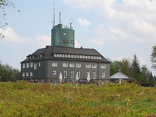
The Kahler Asten is an 841.9-metre-high mountain in the Rothaar range in the district of Hochsauerland, in the German state of North Rhine-Westphalia. It is a popular destination, receiving more than 500,000 visitors annually.

<span class="mw-page-title-main">Langenberg (Rothaar)</span>

The Langenberg rises on the state border between North Rhine-Westphalia and Hesse in Germany and, at 843.2 m above sea level (NN), is the highest peak in the Rothaar mountain range, as well as the highest point in the North Rhine-Westphalia and also in the north of Germany outside the Harz Mountains.

<span class="mw-page-title-main">Rothaarsteig</span>

The Rothaarsteig is a 154.80 km long hiking trail along the crest of the Rothaargebirge mountain range in Germany in the border region between the states of North Rhine-Westphalia (NW) and Hesse (HE). It was opened in 2001.

<span class="mw-page-title-main">Skiliftkarussell Winterberg</span> Ski resort in North Rhine-Westphalia, Germany

Skiliftkarussell Winterberg is one of the major ski resorts in central Germany. It is located near the town of Winterberg in the Hochsauerland region in North Rhine-Westphalia. As an international destination, popular especially with skiers from the Netherlands, it attracts nearly 900,000 visitors annually. Nearby ski resorts are Altastenberg, Postwiese and Willingen.

Dreiskopf is a mountain near Schwalefeld, in the Waldeck-Frankenberg district, in Hesse, Germany. It has an elevation of 779.8 m above sea level, and it's a part of the Rothaar Mountains.

Hohe Warte is a mountain of Landkreis Waldeck-Frankenberg, Hesse, Germany.

Auf'm Knoll in the North Hessian county of Waldeck-Frankenberg, Germany is a hill, 739.1 m above sea level (NHN), in the Upland in the Rothaar mountains. Some parts of the hill belong to North Rhine-Westphalia.

<span class="mw-page-title-main">Süder Uplands</span>

The Süder Uplands, form a major natural region of the Rhenish Massif in the German states of North Rhine-Westphalia and northwestern Hesse. They correspond roughly to the historic regions of the Sauerland, Bergisches Land, Siegerland and Wittgenstein Land in NRW as well as the Upland and the extreme northwest of the Hinterland in Hesse.

The Hohe Egge near Ottlar in the North Hessian county of Waldeck-Frankenberg is a hill, 604.9 m above sea level (NHN), in the Upland in the Rothaar mountains.

<span class="mw-page-title-main">Diemelsee</span> Dam in Waldeck-Frankenberg , Hochsauerlandkreis

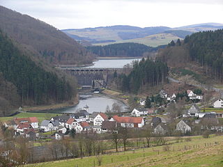
The Diemelsee or Diemel Reservoir is a reservoir with a surface area of 1.65 km² and about capacity of 19.9 million m³ on the River Diemel in the counties of Waldeck-Frankenberg in North Hesse, and Hochsauerlandkreis, Westphalia, Germany.

The Totenkopf is a hill 502.6 m above sea level (NHN), on the Brilon Heights in the counties of Hochsauerlandkreis and Paderborn, in the German state of North Rhine-Westphalia.

References

  1. Hochsauerland (Rothaargebirge)