
Midlothian is a historic county, registration county, lieutenancy area and one of 32 council areas of Scotland used for local government. Midlothian lies in the east-central Lowlands, bordering the City of Edinburgh council area, East Lothian and the Scottish Borders.

Dalkeith is a town in Midlothian, Scotland, on the River Esk. It was granted a burgh of barony in 1401 and a burgh of regality in 1540. The settlement of Dalkeith grew southwestwards from its 12th-century castle . Dalkeith has a population of 12,342 people according to the 2011 census.
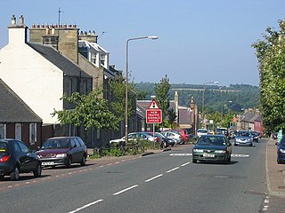
Bonnyrigg is a town in Midlothian, Scotland, which is eight miles southeast of Edinburgh city centre, between the Rivers North and South Esk. The town had a population of 14,663 in the 2001 census which rose to 15,677 in the 2011 census, both figures based on the 2010 definition of the locality which, as well as Bonnyrigg and the adjacent settlement of Lasswade, includes Polton village, Poltonhall housing estate and modern development at Hopefield. The estimated population for 2018 is 18,120, the highest of any town in Midlothian. Along with Lasswade, Bonnyrigg is a twin town with Saint-Cyr-l'École, France.

The River Esk, also called the Lothian Esk, is a river that flows through Midlothian and East Lothian, Scotland.

Gorebridge is a former mining village in Midlothian, Scotland.

Lasswade is a village and civil parish in Midlothian, Scotland, on the River North Esk, nine miles south of Edinburgh city centre, contiguous with Bonnyrigg and between Dalkeith to the east and Loanhead to the west. Melville Castle lies to the north east. The Gaelic form is Leas Bhaid, meaning the "clump at the fort."
Rosewell is a former mining village in Midlothian, Scotland, east of Roslin and south-west of Bonnyrigg. The village is in the civil parish of Lasswade and was previously a separate ecclesiastical parish, but has its own Community Council, namely Rosewell and District.

Cousland is a village in Midlothian, Scotland. It is located 4 kilometres (2.5 mi) east of Dalkeith and 3 kilometres (1.9 mi) west of Ormiston, on a hill between the Rivers Tyne and Esk.

Newbattle High School(formerly Newbattle Community High School) is a non-denominational secondary state school located in Easthouses, Midlothian, Scotland within Newbattle Community Campus, which opened to the public on 26 May 2018. It is run by Midlothian Council and has approximately 900 pupils on roll in six-year groups from ages 11 up to 18, and serves the settlements of Easthouses, Mayfield, Gorebridge and Newtongrange plus the small villages of North Middleton, Temple and Borthwick and their surrounding areas. As of 2018 the school has been designated a Digital Centre for Excellence.
The Archdeaconry of Lothian, located in modern-day Scotland, was a sub-division of the diocese of St Andrews, one of two archdeaconries within the diocese and in essence that part of the diocese which lay south of the Forth. The Lothian archdeaconry was headed by the Archdeacon of Lothian, a subordinate of the Bishop of St Andrews.
Pathhead village is a conservation area in Midlothian, Scotland.
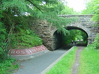
The Penicuik - Dalkeith Walkway, situated in the county of Midlothian in the east of Scotland, stretches for 9.5 miles along the former Edinburgh to Peebles railway. The route passes through many of Midlothian's historic towns and villages. The gentle gradient and nature of the route allows easy access for walkers, cyclists and horse riders to explore and enjoy the spectacular landscapes and visitor attractions of the county.
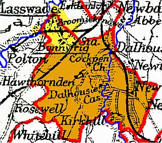
Cockpen is a parish in Midlothian, Scotland, containing at its north-west corner the town of Bonnyrigg, which lies two miles (3.2 km) south-west of Dalkeith. It is bounded on the west and north by the parish of Lasswade, on the east, by Newbattle and on the south by Carrington. It extends about three miles (4.8 km) from north to south and its greatest breadth is about 2+1⁄2 miles (4.0 km).
Glencorse is a parish of Midlothian, Scotland, lying 7 miles south of Edinburgh. It is bounded on the north-west by the former parish of Colinton now within the City of Edinburgh, to the north and west by Lasswade and to the south and west by Penicuik.

Cranston is a parish of Midlothian, Scotland, lying 4+1⁄4 miles south-east of Dalkeith. It is bounded by the parishes of Inveresk and Ormiston on the east, by Crichton and Borthwick on the south ; and by Newbattle on the west and north. The River Tyne flows through the centre of the parish.

Whitehill is a village in Midlothian in the south-east of Scotland, approximately 1.5 miles (2 km) south-east of Dalkeith and 8.5 miles (13.6 km) from Edinburgh. The village is situated on the northwest slope of the Mayfield-Tranent ridge which spans the border between Midlothian and East Lothian. Both road entrances to the village offer magnificent panoramic views over Edinburgh, the Firth of Forth and the Pentland Hills.
Oliver St Clair was a Scottish noble and the 12th Baron of Roslin.
 Borthwick Castle
 Crichton Collegiate Church
 Dalkeith, Corn Exchange
 Dalkeith, St. Mary's Church
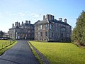 Dalkeith Palace, leased to the University of Wisconsin
 Fala Parish Church
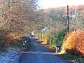 Fala Mill
 Pittendreich House, Lasswade
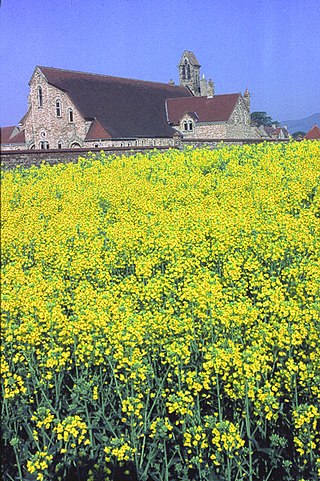
 Newbattle Abbey
 Pentland Hills
 Rosewell Church
 Rosslyn Chapel, Apprentice column
 Vogrie House


