Sydenham Hill

Last updated

Sydenham Hill
Crescent Wood Road, Sydenham, 2013.JPG
Crescent Wood Road
Greater London UK location map 2.svg
Red pog.svg
Sydenham Hill
Location within Greater London
London borough
Ceremonial county Greater London
Region
Country England
Sovereign state United Kingdom
Post town LONDON
Postcode district SE21, SE26, SE23
Dialling code 020
Police Metropolitan
Fire London
Ambulance London
UK Parliament
London Assembly
Website http://sydenham.org.uk/
List of places
UK
England
London
51°25′58″N0°04′08″W / 51.4329°N 0.0690°W / 51.4329; -0.0690

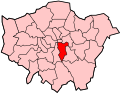
Sydenham Hill forms part of a longer ridge and is an affluent locality in southeast London. It is also the name of a road which runs along the northeastern part of the ridge, demarcating the London Boroughs of Southwark, Bromley, and Lewisham. Its highest part is the apex of the Boroughs of Southwark and Lewisham and the 15th-highest peak in London, at 367 feet (112 m).

Contents

The road connects the A205 road in the northeast at Forest Hill with the A212 road to the southwest at Crystal Palace. Sydenham Hill railway station, Sydenham Hill Wood nature reserve and Dulwich and Sydenham Hill Golf course are on its west slopes thus in the Borough of Southwark. The London boroughs of Lambeth and Croydon have part of the hill within their jurisdiction.

Geography

College Road, SE21, Sydenham Hill Parish Church of St Stephen South Dulwich.JPG
College Road, SE21, Sydenham Hill

Sydenham Hill is approximately 5.6 miles to the southeast of Charing Cross. It is also at the centre of many of south London's major shopping districts being 3.6 miles south of Lewisham, 4.6 miles northwest of Bromley and 4 miles north of Croydon.

Sydenham Hill (as well as Upper Sydenham) is on the large Norwood Ridge formed of London Claygate beds deposits. As a result, Sydenham Hill is one of the highest points in London at 367 feet (112 m). Sydenham Hill Wood is a nine-hectare [1] nature reserve west of Sydenham Hill Road, along with Dulwich and Sydenham Hill Golf course. The hill was once covered by the Great North Wood which covered all of Sydenham, Norwood, Woodside, Gipsy Hill etc.

History

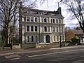
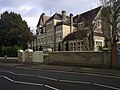
The hill is the summit of the uppermost or eastern ridge of the Norwood Ridge which in turn was for several millennia covered by the Great North Wood but sits on thin topsoil. In the 19th century Sydenham Hill became a fashionable area, with a large number of large residential properties built along Sydenham Hill, including Grange Court (1861), The Wood (1840), Dilkhoosh (now Fountain House) (1864), Highfield (1855), The Cedars (1894), Sydenham Hill House (1898), Dulwich Wood House (1858), Beltwood House (1851) and Castlebar (1879). [2] The writer Joseph Ashby-Sterry was born into a Sydenham Hill family in 1836 or 1838. [3] In 1854, the area's importance was increased after the Crystal Palace was relocated from Hyde Park and re-erected on the south-western end of the ridge.

In 1863, the Chatham Main Line was opened by the London, Chatham and Dover Railway, bringing the railway to Sydenham Hill. Construction involved building a 1.2 mile (1,958 metre) tunnel through the hill, starting at College Road, going under Sydenham, and ending below the Brighton Main Line at Penge. 19 years later in 1884, another line was opened, this time to serve the Crystal Palace. The line had a new station at Upper Sydenham on the southern edge of the ridge, with direct trains to London Victoria via Peckham Rye. However, the line was poorly used, and the destruction of the Crystal Palace made the situation worse, despite the rapid growth of the area. The railway line finally closed in 1954 leaving an abandoned tunnel within the Sydenham Hill Woods.

Area

The area west and north of Sydenham Hill road and Dulwich Wood is widely known as Dulwich, mostly corresponding to the postal code area (SE21), with the east side of the woods being known simply as Sydenham, or Upper Sydenham, corresponding to the SE26 postal area. Sydenham Hill road and the ridge line marks the southern and eastern boundary of the Dulwich Estate.

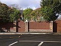
The area is almost 100% residential and have many large homes dating from the 1800s. As of April 2015, the estimated average house price on College Road is £854,149, [4] while on Sydenham Hill (road) the average is £437,478, [5] [ needs update ] with both roads having homes in the £1–6 million range. Peckarmans Wood and Great Brownings are examples of mid-century modern estates designed by Austin Vernon and Partners for the Dulwich Estate. College Road is a private road, with a toll towards Hunts Slip Road, dating back to the 1780s. On the other side of the railway is the Kingswood Housing Estate, with the Dulwich Wood Primary, Kingsdale Foundation Schools and the Kingswood House Community Centre.

Other roads on the hill include: Crescent Wood Road; Woodhall Drive; and, Hitherwood Drive.

Transport

Sydenham Hill station Sydenham Hill, College Road Entrance, 2013.JPG
Sydenham Hill station

Bus

Transport for London bus routes 202, 356, 363, N63 run along the Sydenham Hill road. Route 450 serves Fountain Drive.

Railway

Sydenham Hill railway station is on the private College Road, with another entrance in the Kingswood Estate. The station is served by Southeastern services to London Victoria, Herne Hill, Beckenham Junction, Bromley South and Orpington, with a frequency of every 15 minutes Monday to Saturday, 30 minutes on Sundays. Sydenham Hill is one of a handful of stations in London not to have a dedicated bus stop, with the closest being on Kingswood Drive, 0.3 miles away.

See also

Related Research Articles

<span class="mw-page-title-main">London Borough of Southwark</span> London borough in United Kingdom

The London Borough of Southwark in South London forms part of Inner London and is connected by bridges across the River Thames to the City of London and London Borough of Tower Hamlets. It was created in 1965 when three smaller council areas amalgamated under the London Government Act 1963. All districts of the area are within the London postal district. It is governed by Southwark London Borough Council.

<span class="mw-page-title-main">Crystal Palace, London</span> Residential area in London, England

Crystal Palace is a leafy and hilly area in South London, named after the Crystal Palace Exhibition building which stood in the area from 1854, until it was destroyed by fire in 1936. About 7 miles (11 km) southeast of Charing Cross, it includes one of the highest points in London, at 367 feet (112 m), offering views over the capital.

<span class="mw-page-title-main">Dulwich</span> Human settlement in England

Dulwich is an area in south London, England. The settlement is mostly in the London Borough of Southwark, with parts in the London Borough of Lambeth, and consists of Dulwich Village, East Dulwich, West Dulwich, and the Southwark half of Herne Hill. Dulwich lies in a valley between the neighbouring districts of Camberwell, Crystal Palace, Denmark Hill, Forest Hill, Peckham, Sydenham Hill, and Tulse Hill.

<span class="mw-page-title-main">Penge</span> Suburb of south-east London

Penge is a suburb of South East London, England, now in the London Borough of Bromley, 3.5 miles (5.6 km) west of Bromley, 3.7 miles (6.0 km) north east of Croydon and 7.1 miles (11.4 km) south east of Charing Cross.

<span class="mw-page-title-main">Sydenham, London</span> Human settlement in England

Sydenham is a district of south-east London, England, which is shared between the London boroughs of Lewisham, Bromley and Southwark. Prior to the creation of the County of London in 1889, Sydenham was located in Kent, bordering Surrey. Historically, the area was very affluent, with the Crystal Palace being relocated to Sydenham Hill in 1854. Today, Sydenham is a diverse area, with a population of 28,378 and borders Forest Hill, Dulwich, Crystal Palace, Penge, Beckenham, Catford and Bellingham.

<span class="mw-page-title-main">Upper Norwood</span> Area of south London

Upper Norwood is an area of south London, England, within the London Boroughs of Bromley, Croydon, Lambeth and Southwark. It is north of Croydon. The eastern part of it is better known as the Crystal Palace area. The SE19 London postcode covers the entirety of the district.

<span class="mw-page-title-main">Forest Hill, London</span> Human settlement in England

Forest Hill is a district of the London Borough of Lewisham in south east London, England, on the South Circular Road, which is home to the Horniman Museum.

<span class="mw-page-title-main">South East London Green Chain</span>

The South East London Green Chain, also known as the Green Chain Walk, is a linked system of open spaces between the River Thames and Crystal Palace Park in London, England. In 1977 four London boroughs and the Greater London Council created this Green Chain of 300 open spaces to protect them from building activity. The four London boroughs are Bexley, Bromley, Lewisham and Greenwich. More recently it has been extended to include sections in Southwark. Many parts of the system are also part of the Capital Ring route.

<span class="mw-page-title-main">Lewisham West and Penge (UK Parliament constituency)</span> Parliamentary constituency in the United Kingdom

Lewisham West and Penge is a constituency in Greater London created in 2010 and represented in the House of Commons of the UK Parliament since 2017 by Ellie Reeves of the Labour Party.

<span class="mw-page-title-main">Gipsy Hill</span> Area of south London

Gipsy Hill in south London is a hilly and leafy neighbourhood spanning the southern parts of the London Boroughs of Lambeth and Southwark characterised for its stunning views of the City of London and Dulwich.

<span class="mw-page-title-main">West Dulwich</span> Human settlement in England

West Dulwich is a neighbourhood in South London on the southern boundary of Brockwell Park, which straddles the London Borough of Lambeth and the London Borough of Southwark. Croxted Road and South Croxted Road mark the boundary between Southwark to the east and Lambeth to the west. The suburb of West Dulwich dates back to the 17th century when the often flooded land known as Dulwich Common was acquired and drained by Edward Alleyn's estate.

<span class="mw-page-title-main">Dulwich Wood</span>

Dulwich Wood, together with the adjacent Sydenham Hill Wood, is the largest extant part of the ancient Great North Wood in the London Borough of Southwark. The two woods were separated after the relocation of The Crystal Palace in 1854 and the creation of the high level line in 1865. The wood is privately owned and managed by the Dulwich Estate.

<span class="mw-page-title-main">Norwood Ridge</span> Ridge in south London

The Norwood Ridge is a 10-square-mile (26 km2) rectangular upland which occupies the geographical centre of south London, centred 5 miles (8 km) south of London Bridge. Beneath its topsoil it is a ridge of London Clay that is capped on all sides with remaining natural gravel deposits mixed with some sandy soil, which in the South Thames basin is a material known as the Claygate Beds.

<span class="mw-page-title-main">Crystal Palace (High Level) railway station</span> Former railway station in South London

Crystal Palace (High Level) was a railway station in South London. It was one of two stations built to serve the new site of the Great Exhibition building, the Crystal Palace, when it was moved from Hyde Park to Sydenham Hill after 1851. It was the terminus of the Crystal Palace and South London Junction Railway (CPSLJR), which was later absorbed by the London, Chatham and Dover Railway (LCDR). The station closed permanently in 1954.

<span class="mw-page-title-main">A2216 road</span> Road in southeast London

The A2216 is an A road in south London, England suburbia. It runs from the A215 in Denmark Hill to the A212 in Sydenham. Part of the road is an ancient thoroughfare, Lordship Lane. In Dulwich, the road runs via the A205 South Circular Road.

<span class="mw-page-title-main">A212 road</span> Road in London, England

The A212 is an A road in South London, linking Lewisham to Croydon.

<span class="mw-page-title-main">Great North Wood</span> Wood in south London

The Great North Wood was a natural oak woodland that started three miles (4.8 km) south-east of central London and scaled the Norwood Ridge. At its full extent, the wood's boundaries stretched almost as far as Croydon and as far north as Camberwell. It had occasional landownings as large clearings, well-established by the Middle Ages such as the hamlets of Penge and Dulwich.

<span class="mw-page-title-main">Sydenham Hill Wood</span>

Sydenham Hill Wood is a ten-hectare wood on the northern slopes of the Norwood Ridge in the London Borough of Southwark. It is designated as a Local Nature Reserve and Site of Metropolitan Importance for Nature Conservation. With the adjacent Dulwich Wood, Sydenham Hill Wood is the largest extant tract of the ancient Great North Wood. The two woods are formed from coppices known as Lapsewood, Old Ambrook Hill Wood and Peckarmans Wood after the relocation of The Crystal Palace in 1854 and the creation of the high level line in 1865.

<span class="mw-page-title-main">Beltwood House</span> Grade II listed mansion in south London

Beltwood House is a Grade II listed building within the Dulwich Wood Conservation Area in south London, England. The large three-storey mansion has fifty rooms and stands in 1.24 hectares of wooded grounds, with gatekeeper's lodge. The site has been subject to a blanket tree preservation order since 1985. The house and grounds have been renovated, developed and converted into 12 dwellings which came onto the market in 2022–2023.

References

  1. Evans, Humphrey (28 December 2003). "Secret London: Sydenham Hill – The view from the bridge". The Independent on Sunday. Archived from the original on 25 January 2013. Retrieved 19 July 2012.
  2. "Thames Tributary Effra – Gipsy Hill". Edith's Streets. 17 May 2010. Retrieved 31 August 2011.
  3. Oxford Index Retrieved 29 May 2019.
  4. "Zoopla – College Road, SE21" . Retrieved 4 April 2015. Zoopla – College Road, SE21. Accessed 4 April 2015
  5. "Zoopla – Sydenham Hill" . Retrieved 4 April 2015.