Bournville is a model village on the southwest side of Birmingham, England, founded by the Quaker Cadbury family for employees at its Cadbury's factory, and designed to be a "garden" village where the sale of alcohol was forbidden. Cadbury's is well known for chocolate products – including a dark chocolate bar branded Bournville. Historically in northern Worcestershire, it is also a ward within the council constituency of Selly Oak and home to the Bournville Centre for Visual Arts and the Cadbury's chocolate factory. Bournville is known as one of the most desirable areas to live in the UK; research by the Joseph Rowntree Foundation in 2003 found that it was "one of the nicest places to live in Britain".
Hall Green is an area in southeast Birmingham, England, synonymous with the B28 postcode. It is also a council constituency of Birmingham City Council, managed by its own district committee. Historically it lay within the county of Worcestershire. The 2001 Population Census found that there were 25,921 people living in Hall Green with a population density of 4,867 people per km2, this compares with 3,649 people per km2 for Birmingham.

Northfield is a residential area in outer south Birmingham, in the county of the West Midlands, England, near the boundary with Worcestershire, which it was historically within. It is also a council constituency, managed by its own district committee. The constituency includes the wards of Kings Norton, Longbridge, Weoley Castle and the smaller ward of Northfield that includes West Heath and Turves Green.

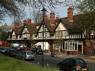
Kings Norton, alternatively King's Norton, is an area of Birmingham, in the county of the West Midlands, England. Historically in Worcestershire, it was also a Birmingham City Council ward within the Government of Birmingham. The district lies 6.5 miles south-southwest of Birmingham city centre and is within 1.5 miles of the north Worcestershire border. Kings Norton has been split into two wards, Kings Norton North and Kings Norton South.

Hollywood is a large village predominantly located in the Bromsgrove district of Worcestershire, England, almost contiguous with and to the south of the city of Birmingham. Hollywood was formerly part of Kings Norton, but when Birmingham expanded in 1911, Hollywood remained in Worcestershire. The village now lies across the wards of Hollywood, most of Drakes Cross, the Trueman's Heath polling district area of Trueman's Heath parish ward and, following a 1966 border change, the southern portion of the Birmingham Highter's Heath ward, with all but the latter being located within the civil parish of Wythall. The southern part of the village is also known as Drakes Cross, whilst the eastern part is sometimes referred to as Trueman's Heath. Hollywood is situated in the extreme northeastern corner of Worcestershire, 8.5 miles / 13 km south of Birmingham city centre, 6 miles / 9.5 km west-southwest of Solihull and 8 miles / 12.5 km northeast of Redditch.

Quinton is a suburb and ward of Birmingham, in the county of the West Midlands, England, 5 miles (8 km) west of the city centre. Formerly part of Halesowen parish, Quinton became part of Birmingham in 1909. Quinton was a village and the surrounding area was farmland until the 1930s when the first housing estates were developed. Most of the farmland had been built on by 1980 but some countryside remains in the form of Woodgate Valley Country Park. Along with Bartley Green, Harborne and Edgbaston, Quinton is within the Birmingham Edgbaston constituency.

West Heath is a residential area of Birmingham, England on the boundary with Worcestershire. Forming the larger part of the ward of Longbridge And West Heath it is situated between Kings Norton, Northfield, Longbridge and Cofton Hackett and lies on traditional heathland formed in the 13th century as part of the Kings Norton manorial lands, and was historically in Worcestershire.

Ashmore Park is a large housing estate in Wednesfield, England. It has been part of the city of Wolverhampton, West Midlands since 1966, when the majority of Wednesfield was incorporated into Wolverhampton. It forms part of the Wednesfield North ward of the City of Wolverhampton council. The estate consists predominantly of council-built houses, flats and bungalows from the 1950s.

Walmley is a suburban village situated in the civil parish of Sutton Coldfield, West Midlands. It lies within the City of Birmingham on its northeastern outer fringe, where it forms part of the Sutton Walmley and Minworth electoral ward. It is in southern Sutton Coldfield, close to Minworth, Erdington, Wylde Green, Pype Hayes and south of Thimble End. It is approximately 7 miles (11.3 km) northeast of Birmingham City Centre. It is the main focus of the Sutton New Hall Birmingham City Council ward.

Hockley Heath is a village and civil parish within the Metropolitan Borough of Solihull, West Midlands, England. The village is to the south of the West Midlands conurbation, 12 miles (19 km) southeast of Birmingham 5.5 miles (8.9 km) from Solihull town centre and 13 miles (21 km) north of Stratford-upon-Avon. Hockley Heath is in the Arden area and borders Warwickshire and the District of Stratford-on-Avon to the south, with some parts of the village on either side of the border. It incorporates the hamlet of Nuthurst, and has a history dating back to the year 705 AD as a wood owned by Worcester Cathedral. The 2011 Census gives the population of Hockley Heath civil parish as 2,038.

Chailey is a village and civil parish in the Lewes District of East Sussex, England. It is located 7 miles north of Lewes, on the A272 road from Winchester to Canterbury. The Prime Meridian passes just to the east of Chailey.
Brandwood is one of 40 wards which constitute Birmingham City Council and is part of the Birmingham Selly Oak constituency. Prior to May 2010, it was a part of the constituency of Birmingham Hall Green. The ward contains a large number of owner-occupied properties around Howard Road, Wheelers Lane, May Lane, Woodthorpe Road, Featherstone Road, Brandwood Road, Lindsworth Road and Alcester Road South, in addition to two big former council estates around Allenscroft Road and Druids Heath, the latter containing 16 high-rise tower blocks. Brandwood is a sub-section area of Kings Heath.

King's Norton and Northfield Urban District was a local government administrative district in north Worcestershire, England, from 1898 until 1911. Much of its area was afterwards absorbed into the neighbouring Borough of Birmingham, under the Greater Birmingham Scheme, and now constitutes most of the city's southern and southwestern suburban environs.

Warstock is a district within the city of Birmingham, UK, in the southernmost suburbs roughly 1 km east of the A435 and within the ward of Highter's Heath. The area lies within the B14 postcode and is contiguous with Yardley Wood to the north-east, Solihull Lodge to the south-east and Highter's Heath to the south-west. Kings Heath lies to the north-west.

The Baverstock Academy was a mixed secondary school and sixth form college, located on the southern edge of the Birmingham outer city ward of Druids Heath.
The Maypole, Birmingham is a location on the A435 road on the southern edge of Birmingham, England, between Druids Heath and Highter's Heath and bordering the Bromsgrove district of Worcestershire. It has a population of 2,260 according to the 2011 Census.

Kings Heath is a suburb of south Birmingham, England, four miles south of the city centre. Historically in Worcestershire, it is the next suburb south from Moseley on the A435 Alcester Road. Since 2018 it has been part of the Brandwood and Kings Heath Ward.
Highter's Heath is a district and ward lying on the southern boundary of the city of Birmingham, UK. The district of Highter's Heath lies immediately east of the Maypole. The first recorded use of the name dates from 1495 as Heyters Heath, however today the name is not one that is particularly in widespread use, indeed only three signposted references to the name exist, when entering the city along Maypole Lane, when entering the city from the bottom of Highters Heath Lane and in Major's Green.


