
Northfield is a residential area in outer south Birmingham, England, near the boundary with Worcestershire, which it was historically within. It is also a council constituency, managed by its own district committee. The constituency includes the wards of Kings Norton, Longbridge, Weoley Castle and the smaller ward of Northfield that includes West Heath and Turves Green.

Selly Oak is an industrial and residential area in south-west Birmingham, England. The area gives its name to Selly Oak ward and includes the neighbourhoods of: Bournbrook, Selly Park, and Ten Acres. The adjoining wards of Edgbaston and Harborne are to the north of the Bourn Brook, which was the former county boundary, and to the south are Weoley, and Bournville. A district committee serves the four wards of Selly Oak, Billesley, Bournville and Brandwood. The same wards form the Birmingham Selly Oak constituency, represented since 2010 by Steve McCabe (Labour). Selly Oak is connected to Birmingham by the Pershore Road (A441) and the Bristol Road (A38). The Worcester and Birmingham Canal and the Birmingham Cross-City Railway Line run across the Local District Centre.

Birmingham Selly Oak is a constituency in the West Midlands, represented in the House of Commons of the UK Parliament since 2024 by Alistair Carns of the Labour Party.

Birmingham Northfield is a constituency represented in the House of Commons of the UK Parliament since 2024 by Laurence Turner, a Labour politician. It represents the southernmost part of the city of Birmingham.

Selly Oak railway station is a railway station in Selly Oak in Birmingham, England, on the Cross-City Line between Redditch, Birmingham and Lichfield.

King's Norton and Northfield Urban District was a local government administrative district in north Worcestershire, England, from 1898 until 1911. Much of its area was afterwards absorbed into the neighbouring Borough of Birmingham, under the Greater Birmingham Scheme, and now constitutes most of the city's southern and southwestern suburban environs.
Lodge Hill Cemetery is a municipal cemetery and crematorium in Selly Oak, Birmingham, England. The cemetery was first opened by King’s Norton Rural District Council in 1895, and during the 1930s became the site of Birmingham's first municipal crematorium.
Northfield Town Football Club is an amateur football club based in the Selly Oak area in the South of the City of Birmingham, England. The senior first team play in the Midland League Division Three.
Edward Holmes (1832–1909) was a British architect from Birmingham, England.
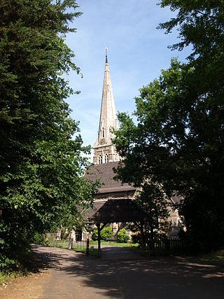
St. Mary's Church, Selly Oak is a Church of England parish church in Selly Oak, Birmingham, England.

St David's Church, Shenley Green is a parish church of the Church of England located in Shenley Green, Birmingham.
St. Gabriel's Church, Weoley Castle is a parish church in the Church of England located in Weoley Castle, Birmingham.

Selly Oak Park is a public park in Selly Oak, Birmingham, England. It is close to the University of Birmingham. The stump from the "Selly Oak", a large oak tree on Oak Tree Lane was situated in the park after it was felled in 1909.

Major George Bernard Cox FRIBA was a British architect and co-founder with Arthur Harrison of Harrison and Cox. He primarily designed Roman Catholic churches.
The Oak Cinema, was an Art Deco style cinema located at the junction of Chapel Lane and Bristol Road, Selly Oak, Birmingham from 1923 to 1984.

Joseph Frederick Ledsam was a Deputy Lord Lieutenant of Warwick, High Sheriff of Worcestershire (1848-1849) and deputy chairman of the London and North Western Railway (1849-1862).


