Bickenhill

Last updated

Bickenhill
St Peter's church, Bickenhill - geograph.org.uk - 3747568.jpg
St Peter's Church in the village
West Midlands UK location map.svg
Red pog.svg
Bickenhill
Location within the West Midlands
OS grid reference SP1882
Civil parish
  • Bickenhill and Marston Green
Metropolitan borough
Metropolitan county
Region
Country England
Sovereign state United Kingdom
Post town SOLIHULL
Postcode district B92
Post townBIRMINGHAM
Postcode district B40
Dialling code 0121
Police West Midlands
Fire West Midlands
Ambulance West Midlands
UK Parliament
Website bmgpc.org
List of places
UK
England
West Midlands
52°26′20″N1°43′30″W / 52.439°N 1.725°W / 52.439; -1.725

Bickenhill is a small village in the civil parish of Bickenhill and Marston Green, in the Metropolitan Borough of Solihull, in the West Midlands county, England, on the eastern fringe of the West Midlands conurbation. Bickenhill is also a ward and was within the historic county of Warwickshire. Birmingham Airport is also located within the civil parish.

Contents

History

The settlement is of Anglo-Saxon origin, and historically the parish included the manors of Church Bickenhill, Hill Bickenhill, Middle Bickenhill, Marston Culy (now Marston Green), [1] and Wavers Marston. [2]

The manor of Bickenhill was held by Edward the Confessor, by Alward, and then by Turchil. [3] The manor was recorded as Bichehelle in the Domesday Book of 1086. [2] [4] The descendants of Turchil, the Arden family, settled in the area and adopted the surname 'de Bickenhill,' though spelt differently. The name developed into de Bickenhill in the 13th century. [5] In 1295, Alice de Langley gave herself the title Lady of Bickenhill. [3] A manor then developed in Bickenhill and by the 15th century, there were two manors. It is believed that both manors shared rights by the end of the century. The manors no longer existed by the end of the 16th century. [5]

The parish of Bickenhill also included Lyndon (or Lyndon Quarter), a detached portion of the parish two miles west. Lyndon was transferred from Bickenhill to Solihull in 1874. Its northern section was later transferred to Birmingham in 1931, while the south became part of Olton, now a suburb of Birmingham. In 1928, Marston Green became a separate ecclesiastical parish, and in 1932, part of Elmdon was added to Bickenhill. [2] [3]

The parish maintained a rural setting in the 19th century but began to develop in the early 20th century into a populous area due to the industrial revolution. No railway station was opened near the village until Birmingham International at Birmingham Airport opened in 1976. [6] The M42 motorway and the busy A45 road run close by to the east and north of the village respectively. Junction 6 of the M42 is known as the Bickenhill Interchange. [7]

It became part of the Metropolitan Borough of Solihull in 1974. [2]

Bickenhill Community Fire Station near the National Exhibition Centre in May 2009 Bickenhill Community Fire Station, West Midlands, England-21May2009.jpg
Bickenhill Community Fire Station near the National Exhibition Centre in May 2009

In 2001 there was a possibility that a replacement for Wembley Stadium might be built in the West Midlands. A campaign urging Londoners to oppose the plan used posters with an image of a young footballer saying "One day I'll play at Bickenhill". [8]

Parish

The parish of Bickenhill and Marston Green [9] covers the villages of both Bickenhill and Marston Green. Also in the parish are Birmingham Airport, the National Exhibition Centre, and the National Motorcycle Museum. [4] [5] In the 2011 census the parish population was 7,153, [10] an increase from the 2001 Census figure of 6,583. [5] Solihull Metropolitan Borough Council maintain a waste recycling centre in the parish. [11] The civil parish was renamed from Bickenhill to Bickenhill and Marston Green in 2014. [12]

The parish is crossed by two major roads: the M42 and the A45. The A45 is referred to locally as the Coventry Road.

Village

The village of Bickenhill is south of the A45 road (whereas the rest of the parish is north of the A45). The Church of England parish church of Saint Peter is Norman and was built in 1140; it is grade I listed. [13] [14] The toponym 'Bickenhill' is derived from the Old English meaning 'Bica's hill', [2] [5] [15] with it spelt as Bichehelle in the Domesday Book of 1086. [2] The majority of the older houses in Bickenhill village are Georgian or Victorian. [5]

In 2003, a proposal was announced to build a second runway at Birmingham Airport which would have reportedly have involved demolition of between 100 and 150 buildings in the Bickenhill conservation area. [16]

The centre of the village is a Conservation area, and in a response to the Planning Inspectorate in 2019 Solihull Council described its value as "High" and said that it "has a focal building in the grade 1 listed mediaeval parish church on locally high ground at the heart of a group of historic and other buildings typifying an English midlands village. This includes the grade 2 listed Grange Farm and several buildings on the Local List of Heritage Assets, served by narrow sinuous lanes with enclosing banks and hedgerows, beyond which are many surviving fields and paddocks often representing an historic layout". [17]

Páirc na hÉireann, off Catherine de Barnes Lane, is the primary venue for Gaelic games in the West Midlands. [18] It has three full-size Gaelic Athletic Association pitches with eight changing rooms, bar area and car-parking. [19]

Nearby villages include Catherine-de-Barnes, Hampton in Arden and Meriden.

Governance

The two main local authorities responsible for the parish are Solihull Metropolitan Borough Council and Bickenhill Parish Council. [9] The Parish Council is responsible for maintaining facilities such as churchyards, cemeteries and parks in the parish [20] and its offices are located at a park near Marston Green. [21]

Bickenhill ward elects three councillors to the metropolitan borough council. [22]

Related Research Articles

<span class="mw-page-title-main">West Midlands (county)</span> County of England

West Midlands is a metropolitan and ceremonial county in the larger West Midlands region of England. A landlocked county, it is bordered by Staffordshire to the north and west, Worcestershire to the south, and is surrounded by Warwickshire to the east. The largest settlement is the city of Birmingham.

<span class="mw-page-title-main">Birmingham Airport</span> International airport in Birmingham, England, United Kingdom

Birmingham Airport, formerly Birmingham International Airport, is an international airport located 7 nautical miles east-southeast of Birmingham city centre, 9.5 nautical miles west-northwest of Coventry slightly north of Bickenhill village, in the Metropolitan Borough of Solihull, England.

<span class="mw-page-title-main">Warwickshire</span> County of England

Warwickshire is a ceremonial county in the West Midlands of England. It is bordered by Staffordshire and Leicestershire to the north, Northamptonshire to the east, Oxfordshire and Gloucestershire to the south, and Worcestershire and the West Midlands county to the west. The largest settlement is Nuneaton and the county town is Warwick.

<span class="mw-page-title-main">Knowle, West Midlands</span> Human settlement in England

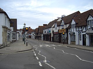
Knowle is a large village situated 3 miles (5 km) east-southeast of the town of Solihull, West Midlands, England. Knowle lies within the Arden area of the historic county boundaries of Warwickshire, and since 1974 it has been part of the Metropolitan Borough of Solihull within the West Midlands. It lies 2.5 miles from the Warwickshire border and had a recorded population of 10,678.

<span class="mw-page-title-main">North Warwickshire</span> Borough and non-metropolitan district in England

North Warwickshire is a local government district with borough status in Warwickshire, England. The borough includes the two towns of Atherstone and Coleshill, and the large villages of Polesworth, Kingsbury, Hartshill and Water Orton along with smaller villages and surrounding rural areas.

<span class="mw-page-title-main">Hampton in Arden</span> Village in Solihull, England

Hampton in Arden is a village and civil parish located in the Forest of Arden in the Metropolitan Borough of Solihull, in the West Midlands of England. Hampton in Arden was part of Warwickshire until the 1974 boundary changes. It lies within the Meriden Gap which is an area of countryside between Solihull and Coventry.

<span class="mw-page-title-main">Metropolitan Borough of Solihull</span> Metropolitan borough in England

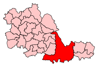
The Metropolitan Borough of Solihull is a metropolitan borough in West Midlands county, England. It is named after its largest town, Solihull, from which Solihull Metropolitan Borough Council is based. For Eurostat purposes it is a NUTS 3 region and is one of seven boroughs or unitary districts that comprise the "West Midlands" NUTS 2 region. Much of the large residential population in the north of the borough centres on the communities of Castle Bromwich, Kingshurst, Marston Green and Smith's Wood as well as the towns of Chelmsley Wood and Fordbridge. In the south are the towns of Shirley and Solihull, as well as the large villages of Knowle, Dorridge, Meriden and Balsall Common.

<span class="mw-page-title-main">Government of Birmingham</span>

Birmingham, a city and metropolitan borough in the West Midlands, England, is the second-largest city in the United Kingdom.

<span class="mw-page-title-main">Meriden (UK Parliament constituency)</span> Parliamentary constituency in the United Kingdom, 1955-2024

Meriden was a constituency represented in the House of Commons of the UK Parliament. It was named after the village of Meriden, halfway between Solihull and Coventry.

<span class="mw-page-title-main">Marston Green</span> Village in England

Marston Green is a village in the civil parish of Bickenhill and Marston Green, in the Metropolitan Borough of Solihull in the West Midlands. It lies within the historic county of Warwickshire. The Parish which includes the village had a population of 7,432 in the 2021 Census.

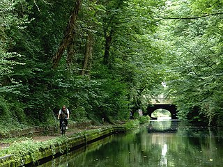
The Meriden Gap is a mostly rural area in the West Midlands between Solihull and Coventry. It is a part of the wider West Midlands Green Belt, separating Coventry from the large West Midlands conurbation, which includes Birmingham and Wolverhampton. The 'Gap' takes its name from the village central to the area, Meriden, although the largest settlement is Balsall Common. The highest point lies at 181 metres (594 ft) above sea level, slightly north of the hamlet of Eaves Green near the West Midlands-Warwickshire border.

<span class="mw-page-title-main">Marston Green railway station</span>

Marston Green railway station is a station serving Chelmsley Wood and Marston Green in the Metropolitan Borough of Solihull and the Birmingham suburbs of Lea Hall and Sheldon in the West Midlands County, England. The station, and all trains serving it, are operated by West Midlands Trains.

<span class="mw-page-title-main">Olton</span> Human settlement in England

Olton is an area/suburban village within the Metropolitan Borough of Solihull in the West Midlands, England. In the 13th century, the Lords of the Manor moved their seat and formed a new settlement, at the junction of two major roads. It was then that Ulverlei was being referred to as ‘Oulton’ to distinguish itself from nearby Solihull. Historically within the county of Warwickshire, the village has gradually become contiguous with Solihull to the southeast, though it retains the character of a large independent village.

<span class="mw-page-title-main">Fordbridge</span> Town and civil parish in West Midlands, England

Fordbridge is a town and civil parish in the Metropolitan Borough of Solihull, in the West Midlands, England. It is 8 miles (13 km) east of Birmingham. According to the 2001 census, the parish had a population of 8,749. Fordbridge lies within the historic county of Warwickshire.

<span class="mw-page-title-main">Kingshurst</span> Village in England

Kingshurst is a post-war village and civil parish in the Metropolitan Borough of Solihull, in the West Midlands, England. Historically part of the county of Warwickshire in the Meriden Rural District, It lies about 7 miles (11 km) north of Solihull town centre, 10 miles (16 km) east of Birmingham and 10 miles (16km) west of Coventry, it borders North Warwickshire to the east. The village is encompassed within the electoral ward Kingshurst & Fordbridge which had a population of 7,868 in the 2011 census.

Catherine-de-Barnes is a small village within the Metropolitan Borough of Solihull in the English county of West Midlands. It is situated about 2.25 miles east of Solihull town centre, in the civil parish of Hampton in Arden, and 2 miles west of Hampton village. Population as taken in the 2011 census can be found under Bickenhill.

<span class="mw-page-title-main">Solihull Metropolitan Borough Council</span>

Solihull Metropolitan Borough Council, also known as Solihull Council, is the local authority for the Metropolitan Borough of Solihull in the West Midlands, England. It is a metropolitan borough council and provides the majority of local government services in the borough. The council has been a member of the West Midlands Combined Authority since 2016.

<span class="mw-page-title-main">Solihull</span> Town in West Midlands, England

Solihull is a market town and the administrative centre of the Metropolitan Borough of Solihull, in the West Midlands, England. Solihull is situated on the River Blythe in the Forest of Arden area. The town had a population of 126,577 at the 2021 Census, and its wider borough had a population of 216,240. The town is located 8 miles (12 km) southeast of Birmingham and 13 miles (21 km) west of Coventry.

<span class="mw-page-title-main">Elmdon, West Midlands</span> Village in England

Elmdon is a suburban village in the civil parish of Bickenhill and Marston Green, in the Solihull district, in the county of the West Midlands, England. It is in the ancient county of Warwickshire. The population of this Solihull Ward at the 2011 census was 12,067. In 1931 the parish had a population of 225. On 1 April 1932 the parish was abolished and merged with Bickenhill and Solihull Urban.

Earlswood is a small village in Warwickshire, England in the Tanworth-in-Arden Civil parish of the Stratford-on-Avon District. However, the northernmost part of the village lies within Tidbury Green parish in the Solihull Metropolitan Borough of the West Midlands. A hamlet called Warings Green also lies in the south east of the village, with the northernmost point crossing into the parish of Cheswick Green in the borough of`Solihull. The village's postal code, B94, is in the Birmingham postcode area. It is in the ecclesiastical parish of St Patrick, Salter Street. The village is surrounded by farmland and forests and it gives its name to Earlswood Lakes as well as to Earlswood railway station, even though The Lakes railway station is located closer to the main part of the village.

References

  1. "Marston Green history". www.solihull.gov.uk. Retrieved 4 July 2023.
  2. 1 2 3 4 5 6 "Bickenhill history". www.solihull.gov.uk. Retrieved 4 July 2023.
  3. 1 2 3 "Parishes: Bickenhill | British History Online". www.british-history.ac.uk. Retrieved 4 July 2023.
  4. 1 2 "Bickenhill Village in Solihull". Visit Solihull. Retrieved 4 July 2023.
  5. 1 2 3 4 5 6 "History | Bickenhill & Marston Green Parish Council Online" . Retrieved 4 July 2023.
  6. "Birmingham International station set for £300m revamp". BBC News. 24 July 2020. Retrieved 4 July 2023.
  7. Marshall, C., M42 J6 Bickenhill Interchange, accessed 11 June 2023
  8. Kleinmann, Mark (2 August 2001). "GLA campaign to fight for football at Wembley". Campaign. Retrieved 1 July 2023.
  9. 1 2 "Welcome to the Parish Council website". Bickenhill & Marston Green Parish Council. Retrieved 9 January 2022.
  10. UK Census (2011). "Local Area Report – Bickenhill Parish (E04000148)". Nomis. Office for National Statistics.
  11. "Bickenhill Household Waste and Recycling Centre (tip) | solihull.gov.uk". www.solihull.gov.uk. Retrieved 4 July 2023.
  12. "Bulletin of change 2014" (PDF). Lgbce. Archived from the original (PDF) on 16 March 2018. Retrieved 15 March 2018.
  13. Historic England. "Church of Saint Peter (1343224)". National Heritage List for England .
  14. "St Peters Church Bickenhill". www.achurchnearyou.com. Retrieved 1 July 2023.
  15. "Bickenhill :: Survey of English Place-Names". epns.nottingham.ac.uk. Retrieved 4 July 2023.
  16. "Government backs second runway". icBirmingham. 16 December 2003. Archived from the original on 29 June 2011.
  17. Solihull Council to Planning Inspectorate, 28 August 2019
  18. "Warwickshire Gaelic Athletics Association vows to fight M42 Relief Road plans which cut through heart of club". Solihull Observer. Retrieved 4 July 2023.
  19. McLaughlin, Anthony. "Plans for Warwickshire GAA's new Pairc na hÉireann site due to be decided this week". The Irish Post. Retrieved 4 July 2023.
  20. "About Us | Bickenhill & Marston Green Parish Council Online" . Retrieved 4 July 2023.
  21. "Get in touch | Bickenhill & Marston Green Parish Council Online" . Retrieved 4 July 2023.
  22. "Your Councillors". eservices.solihull.gov.uk. 4 July 2023. Retrieved 4 July 2023.

Further reading