River Rea

Last updated

Rea
River Rea - Bham Belgrave Middleway.jpg
The River Rea at Belgrave Middleway (Birmingham)
Etymology"to flow" (Old English)
Location
Country England
Physical characteristics
Source 
  location Waseley Hills Country Park, Worcestershire
Mouth  
  location
Confluence with the Tame
  coordinates
52°30′15″N1°50′37″W / 52.50417°N 1.84361°W / 52.50417; -1.84361 Coordinates: 52°30′15″N1°50′37″W / 52.50417°N 1.84361°W / 52.50417; -1.84361
Length14 miles (23 km)
Basin features
Progression Tame Trent Humber North Sea

The River Rea (pronounced "ray") is a small river which passes through Birmingham, England. It is the river on which Birmingham was founded by the Beorma tribe in the 7th century.

Contents

Name

The name of the Rea derives from a root found in many Indo-European languages and means "to run" or "to flow".

Course

The Rea rises in Waseley Hills Country Park, with the source well signposted from the car park there. The river drops about 70 metres (230 ft) in its first mile, but from then on has a very gentle slope. The river's tributaries include Callow Brook, the Bourne (which begins as Merritts Brook before joining Griffins Brook) and Bourne Brook. From Rubery, the river flows into Birmingham near the former Rover works at Longbridge, then flows through a tunnel under the A38. In Northfield, one of the river's few remaining fords is at The Mill Walk, near Hawkesley Mill Lane. After this, the river valley is also used by the railway to Kings Norton.

A floodgate on the river at Vaughton's Hole (now Vaughton St), Highgate, Birmingham, drawn in 1831 by Henry Harris Lines Lines family sketchbook - Vaughton Hole 010.jpg
A floodgate on the river at Vaughton’s Hole (now Vaughton St), Highgate, Birmingham, drawn in 1831 by Henry Harris Lines
One of the Gooch Street Bridge arches River Rea - Bham Gooch Street - Memorial.jpg
One of the Gooch Street Bridge arches

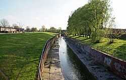
Wychall Reservoir, near the river at Kings Norton, was built in the early 19th century by the Worcester Canal Company after mill owners claimed that water was being taken from the river to fill the canal and reducing the working effectiveness of their mills. Following Kings Norton, the river flows through Stirchley. It is now culverted for much of its course through Birmingham, during which it passes through the Pebble Mill area and Cannon Hill Park then Calthorpe Park. A pair of decorative arches on the bridge where Gooch Street crosses the river mark the first settlement of Birmingham. The medieval hamlet of Birmingham was built on a crossing on the Rea in what is now Digbeth. Many of the street names in the area refer to the river or its mills. These include Rea Street, Floodgate Street, River Street and Duddeston Mill Road. There are proposals to include a riverside walk and new bridge over the Rea at Digbeth's Custard Factory media and arts complex (now complete). There are also proposals for the river to be uncovered at the Warwick Bar area of Digbeth.

Near Gravelly Hill Interchange, about 14 miles (23 kilometres) from its source, the Rea merges with the River Tame, with its waters eventually reaching the North Sea via the Trent and the Humber Estuary.

Flood prevention measures

The Rea frequently bursts its banks after heavy rain. A £2.7 million scheme to reduce the risk of flooding to homes and businesses in the south of Selly Park was completed in January 2018. [1]

See also

Related Research Articles

<span class="mw-page-title-main">Grand Union Canal</span> Canal in England

The Grand Union Canal in England is part of the British canal system. It is the principal navigable waterway between London and the Midlands. Starting in London, one arm runs to Leicester and another ends in Birmingham, with the latter stretching for 137 miles (220 km) with 166 locks from London. The Birmingham line has a number of short branches to places including Slough, Aylesbury, Wendover, and Northampton. The Leicester line has two short arms of its own, to Market Harborough and Welford.

<span class="mw-page-title-main">Birmingham and Fazeley Canal</span> Canal in the United Kingdom

The Birmingham and Fazeley Canal is a canal of the Birmingham Canal Navigations in the West Midlands of England. Its purpose was to provide a link between the Coventry Canal and Birmingham and thereby connect Birmingham to London via the Oxford Canal.

<span class="mw-page-title-main">River Tame, West Midlands</span> River in the West Midlands of England

The River Tame is a river in the West Midlands of England, and one of the principal tributaries of the River Trent. The Tame is about 95 km (59 mi) long from the source at Oldbury to its confluence with the Trent near Alrewas, but the main river length of the entire catchment, i.e. the Tame and its main tributaries, is about 285 km (177 mi).

<span class="mw-page-title-main">River Cole, West Midlands</span> River in the English Midlands

The River Cole is a 25 miles (40 km) river in the English Midlands. It rises on the lower slopes of Forhill, one of the south-western ramparts of the Birmingham Plateau, at Red Hill and flows south before flowing largely north-east across the plateau to enter the River Blythe below Coleshill, near Ladywalk, shortly before the Blythe meets the Tame. This then joins the Trent, whose waters reach the North Sea via the Humber Estuary. Its source is very near the main watershed of Midland England : tributaries are few and very short except in the lower reaches, so the Cole is only a small stream.

<span class="mw-page-title-main">Northfield, Birmingham</span> Human settlement in England

Northfield is a residential area in outer south Birmingham, England, and near the boundary with Worcestershire. It is also a council constituency, managed by its own district committee. The constituency includes the wards of Kings Norton, Longbridge, Weoley Castle and the smaller ward of Northfield that includes West Heath and Turves Green.

<span class="mw-page-title-main">Selly Oak</span> Human settlement in England

Selly Oak is an industrial and residential area in south-west Birmingham, England. The area gives its name to Selly Oak ward and includes the neighbourhoods of: Bournbrook, Selly Park, and Ten Acres. The adjoining wards of Edgbaston and Harborne are to the north of the Bourn Brook, which was the former county boundary, and to the south are Weoley, and Bournville. A district committee serves the four wards of Selly Oak, Billesley, Bournville and Brandwood. The same wards form the Birmingham Selly Oak constituency, represented since 2010 by Steve McCabe (Labour). Selly Oak is connected to Birmingham by the Pershore Road (A441) and the Bristol Road (A38). The Worcester and Birmingham Canal and the Birmingham Cross-City Railway Line run across the Local District Centre.

<span class="mw-page-title-main">Digbeth</span> District in Birmingham, England

Digbeth is an area of Central Birmingham, England. Following the destruction of the Inner Ring Road, Digbeth is now considered a district within Birmingham City Centre. As part of the Big City Plan, Digbeth is undergoing a large redevelopment scheme that will regenerate the old industrial buildings into apartments, retail premises, offices and arts facilities. The district is considered to be Birmingham's 'Creative Quarter'.

Stirchley is in south-west Birmingham, England.

<span class="mw-page-title-main">River Brent</span> River in London, England

The River Brent is a river in west and northwest London, England, and a tributary of the River Thames. 17.9 miles (28.8 km) in length, it rises in the Borough of Barnet and flows in a generally south-west direction before joining the Tideway stretch of the Thames at Brentford.

<span class="mw-page-title-main">Hogsmill River</span> River in Surrey and Greater London, England

The Hogsmill River in Surrey and Greater London, England is a small chalk stream tributary of the River Thames. It rises in Ewell and flows into the Thames at Kingston upon Thames on the lowest non-tidal reach, that above Teddington Lock.

<span class="mw-page-title-main">Warwickshire ring</span>

The Warwickshire ring is a connected series of canals forming a circuit around the West Midlands area of England. The ring is formed from the Coventry Canal, the Oxford Canal, the Grand Union Canal, the Stratford-upon-Avon Canal and the Birmingham and Fazeley Canal. It is a popular route with tourists due to its circular route and mixture of urban and rural landscapes.

<span class="mw-page-title-main">Rea Brook</span> River in Shropshire, England

The name Rea Brook can refer to either of two brooks in Shropshire, England.

<span class="mw-page-title-main">Bordesley, Birmingham</span> Human settlement in England

Bordesley is an area of Birmingham, England, 1.2 miles (2 km) south east of the city centre straddling the Watery Lane Middleway ring road. It should not be confused with nearby Bordesley Green. Commercial premises dominate to the west of the ring road, but much of this area is to be redeveloped. Blocks of residential apartments are planned and set for completion from the mid-2020s onwards. The largely residential area east of the ring road was renamed Bordesley Village following large scale clearance of back-to-back houses and redevelopment in the 1980s and 90s. Bordesley is the real life setting of the BBC series Peaky Blinders, and home to Birmingham City Football Club's ground, St Andrew's.

<span class="mw-page-title-main">Eastside, Birmingham</span>

Eastside is a district of Birmingham City Centre, England that is undergoing a major redevelopment project. The overall cost when completed is expected to be £6–8 billion over ten years which will result in the creation of 12,000 jobs. 8,000 jobs are expected to be created during the construction period. It is part of the larger Big City Plan project.

<span class="mw-page-title-main">Warwick Bar</span>

The Warwick Bar conservation area is a conservation area in Birmingham, England which was home to many canalside factories during the Industrial Revolution of the eighteenth and nineteenth centuries.

<span class="mw-page-title-main">River Bourne, Chertsey</span> River in Berkshire and Surrey, England

The River Bourne or the Chertsey Bourne is in Berkshire and Surrey; it runs from sources in Windsor Great Park and Swinley Forest through to the River Thames.

<span class="mw-page-title-main">River Bourne, Addlestone</span> River in northwest Surrey, England

The River Bourne is the name given to a Thames tributary in northwest Surrey, England which has a longer tributary, the Windle Brook, that rises nears Bagshot Park in the south of Swinley Forest, Berkshire, merging with it while flowing through villages north of Woking; downstream the Bourne joins the Thames near Weybridge.

This article is intended to show a timeline of events in the History of Birmingham, England, with a particular focus on the events, people or places that are covered in Wikipedia articles.

<span class="mw-page-title-main">Lea Valley Walk</span> Long-distance footpath in South East England

The Lea Valley Walk is a 50-mile (80 km) long-distance path located between Leagrave, the source of the River Lea near Luton, and the Thames, at Limehouse Basin, Limehouse, east London. From its source much of the walk is rural. At Hertford the path follows the towpath of the River Lee Navigation, and it becomes increasingly urbanised as it approaches London. The walk was opened in 1993 and is waymarked throughout using a swan logo.

<span class="mw-page-title-main">Camp Hill, Birmingham</span> Place in West Midlands, England

Camp Hill is the name of a road and surrounding area in Birmingham, West Midlands, England 1 mile (2 km) south east of the city centre.

References

  1. "New multi-million pound flood scheme in Birmingham opened - GOV.UK". UK Government. 19 January 2018. Retrieved 20 January 2018.

Further reading