West Midlands conurbation

Last updated

West Midlands
  • Birmingham and the Black Country
  • Birmingham-Wolverhampton Greater Birmingham
Big Brum and Chamberlain Memorial, Chamberlain Square, Birmingham - geograph.org.uk - 3814523.jpg
Market Place, Wolverhampton - geograph.org.uk - 3815661.jpg
Dudley Town Centre.jpg
West Bromwich Town Hall.jpg
High Street, Solihull - geograph.org.uk - 4213860.jpg
Streets of the town 3 - Walsall, West Midlands - geograph.org.uk - 4514940.jpg
West Midlands BUA 2011 with TTWA overlay.png
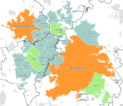
Map of the West Midlands conurbation in 2011, with Travel to Work Areas overlaid. The five most populous are highlighted with Birmingham and Wolverhampton sub-divisions in orange and the Dudley, Walsall and Solihull sub-divisions in green.
Sovereign state United Kingdom
Constituent country England
Largest settlements
Population
  Total2,440,986
  Rank 3rd
Time zone UTC+0 (GMT)
  Summer (DST) UTC+1 (BST)
Postcode
B, DY, WS, WV
Area code(s) 0121, 01543, 01562, 01384, 01902, 01922

The West Midlands conurbation is the large conurbation in the West Midlands region of England. The area consists of two cities and numerous towns: to the east, the city of Birmingham, along with adjacent towns of Solihull and Sutton Coldfield; and to the west, the city of Wolverhampton and the area called the Black Country, containing the towns of Dudley, Walsall, West Bromwich, Oldbury, Willenhall, Bilston, Darlaston, Tipton, Smethwick, Wednesbury, Rowley Regis, Stourbridge and Halesowen.

Contents

It is broken down into multiple Travel to Work Areas: Birmingham, Wolverhampton, Dudley & Sandwell , Walsall & Cannock , Hagley is within the Kidderminster area and the extreme south-east corner is within the Warwick & Stratford upon Avon area. The conurbation is mainly in the West Midlands county, including parts of the surrounding counties of Staffordshire (e.g. Little Aston, Perton and Essington) and Worcestershire (such as Hagley and Hollywood), with Coventry a separate area in the county.

According to the 2011 Census the area had a population of 2,440,986, [1] making it the third most populated in the United Kingdom behind Greater London and Greater Manchester.

With the West Midlands also being a region and county, the conurbation is sometimes known as Birmingham-Wolverhampton. [2] [3] [4] [5] [6] though it is the term Birmingham & The Black Country that has gained the widest traction as an alternative to the conurbation's official name: an example of this is the tagline used by BBC Radio WM - "The sound of Birmingham & The Black Country". [7] [8]

Constituent parts

The West Midlands Urban Area as at the 2001 Census WestMidlandsUrbanArea.svg
The West Midlands Urban Area as at the 2001 Census

Although the exact boundaries of any conurbation are open to debate, dependent on what criteria are used to determine where an urban area ceases, the Office for National Statistics defines the West Midlands Built Up Area as including the urban areas of Birmingham, Wolverhampton, Solihull, West Bromwich, Dudley, and Walsall amongst others. These settlements are not coterminous with the Metropolitan Boroughs of the same name.[ citation needed ]

Coventry is separated from the West Midlands conurbation by the Meriden Gap, and other urban areas, such as Cannock and Codsall remain separate from the conurbation. Coventry is 19 miles east of Birmingham.

West Bromwich Street market in West Bromwich - geograph.org.uk - 3046127.jpg
West Bromwich
St Peter's Collegiate Church in Wolverhampton. St Peter's Church, Wolverhampton.jpg
St Peter's Collegiate Church in Wolverhampton.
Solihull High Street. Solihull High Street.jpg
Solihull High Street.
Walsall Walsall town centre canal wharf - geograph.org.uk - 2553181.jpg
Walsall
Dudley Town Centre. Dudley Town Centre - geograph.org.uk - 1101887.jpg
Dudley Town Centre.
West Midlands conurbation at night from the ISS. ISS Birmingham at night.jpg
West Midlands conurbation at night from the ISS.

Administration

Occasionally the conurbation is seen as being coterminous with the West Midlands Metropolitan county; however, this includes Coventry, which is separate from the main urban area, and excludes the parts of the surrounding counties of Staffordshire, Warwickshire and Worcestershire that fall within the conurbation.

For administrative purposes, the vast majority of the conurbation falls within the six Metropolitan Boroughs of Birmingham, Dudley, Sandwell, Solihull, Walsall and Wolverhampton.

Two Local enterprise partnerships (LEPs) cover the majority of the conurbation area: Black Country LEP comprises the local authorities of Dudley, Sandwell, Walsall and Wolverhampton while the Greater Birmingham & Solihull LEP includes those two authorities and a number of satellite boroughs, many remote from the conurbation and not traditionally associated with it (Bromsgrove, Cannock Chase, East Staffordshire, Lichfield, Redditch, Tamworth and Wyre Forest).

Settlements

2011 Census

The West Midlands Built Up Area consists of the below subdivisions. Due to the change in methodology between the 2001 and 2011 Census, and the amount of change between 2011 Census and previous census data, it is impossible to compare the data directly between 2011 and earlier Censuses.

RankSettlementPopulation (2011) [1] Notes on significant changes since 2001
1 Birmingham 1,085,810Gained Quinton from Oldbury-Smethwick USD. Gained Minworth from Sutton Coldfield USD.
2 Wolverhampton 210,319 Bilston and Wednesfield removed from 2001. The three BUASDs combined total 265,178. Essington removed and placed within Willenhall BUASD.
3 Solihull 123,187Gained Shelly Green and Knowle-Bentley Heath from 2001.
4 Sutton Coldfield 95,107
5 Dudley 79,379 Coseley, Kingswinford, Brierley Hill and Sedgley removed from 2011. The five BUASDs combined total 215,693. Gained Cradley Heath and Quarry Bank from Oldbury-Smethwick USD.
6 West Bromwich 72,945 Wednesbury and Tipton removed from 2001. Town split in two by Sandwell Valley and the two parts are now considered separately. The four BUASDs combined total 153,366. Gained Yew Tree from 2001.
7 Walsall 67,594 Willenhall, Darlaston and Bloxwich removed from 2001. The four BUASDs combined total 185,114.
8 Stourbridge 63,298Gained Hagley from 2001.
9 Halesowen 58,135
10 Willenhall 51,429New in 2011. Previously part of Walsall USD, but also gained Essington from Wolverhampton USD.
11 Kingswinford 50,801New in 2011. Previously part of Dudley USD.
12 Smethwick 48,765New in 2011. Previously part of Oldbury-Smethwick USD.
13 Bloxwich 47,288New in 2011. Previously part of Walsall USD.
13 Tipton 42,407New in 2011. Previously part of West Bromwich USD.
14 Aldridge 39,463Gained Rushall, Shelfield and Pelsall from 2001.
15 Rowley Regis 34,260New in 2011. Previously part of Oldbury-Smethwick USD.
16 Brierley Hill 31,430New in 2011. Previously part of Dudley USD.
17 Sedgley 30,979New in 2011. Previously part of Dudley USD.
18 Bilston 29,556New in 2011. Previously part of Wolverhampton USD.
19 Wednesfield 25,303New in 2011. Previously part of Wolverhampton USD
20 Oldbury 23,964New in 2011. Previously part of Oldbury-Smethwick USD.
21 Coseley 23,104New in 2011. Previously part of Dudley USD.
22 Brownhills 20,373
23 Wednesbury 19,029New in 2011. Previously part of West Bromwich USD.
24 West Bromwich East18,985New in 2011. Previously part of West Bromwich USD.
25 Darlaston 18,803New in 2011. Previously part of Walsall USD.
26 Blackheath 6,518New in 2011. Previously part of Oldbury-Smethwick USD.
27 Cheswick Green 2,197
28 Wythall 1,912New in 2011.
29 Hampton in Arden 1,678New in 2011.
30 Stonnall 1,338New in 2011.
31 Major's Green 1,002New in 2011.
32 Tidbury Green 720New in 2011.

In the 2011 Census, Coleshill and Water Orton are two separate built-up areas with populations of 6,341 and 3,444 respectively. Prior to 2011, they were considered part of the West Midlands Urban Area.

Prior censuses

Prior to the 2011 census, the conurbation was known by the ONS as the West Midlands Urban Area, which contained the following Urban Sub-Divisions:

Rank

(2001)

SettlementPopulation

(2001) [9]

Population

(1991) [10]

Population

(1981) [11]

1 Birmingham 970,892965,9281,024,118
2 Wolverhampton 251,462257,943265,631
3 Dudley 194,919192,171187,367
4 Walsall 170,994174,739178,852
5 Oldbury / Smethwick 139,855145,542153,461
6 West Bromwich 136,940146,386154,531
7 Sutton Coldfield 105,452106,001103,097
8 Solihull 94,75394,53194,613
9 Stourbridge 55,48055,62455,499
10 Halesowen 55,27357,91857,532
11 Brownhills 19,86618,15918,200
12 Knowle / Bentley Heath 18,452
13 Aldridge 15,65916,83217,589
14 Pelsall 10,52410,00710,328
15 Shelfield 6,8077,0796,029
16 Coleshill 6,2356,324
17 Yew Tree 6,109
18 Rushall 5,8645,8716,137
19 Hagley 5,7235,4175,754
20 Shelly Green 5,702
21 Water Orton 3,5733,555
22 Cheswick Green 2,2612,511
23 Knowle 17,58816,872
24 Bentley Heath 5,984

Notes:

  • Knowle and Bentley Heath are considered as one settlement in 2001, but are considered separately in 1991 and 1981. Bentley Heath was not considered to be a settlement within the West Midlands Urban Area in 1981.
  • Coleshill and Water Orton were not considered to be part of the West Midlands Urban Area in 1981, but a separate Coleshill/Water Orton Urban Area with a total population of 9,554; made up of Coleshill (6,113) and Water Orton (3,441).
  • Yew Tree is only considered part of the West Midlands Urban Area in the 2001 census.
  • Cheswick Green was not considered to be a settlement within the West Midlands Urban Area in 1981.
  • Shelly Green was not considered to be a settlement within the West Midlands Urban Area in 1981 or 1991.

See also

Related Research Articles

<span class="mw-page-title-main">West Midlands (county)</span> County of England

West Midlands is a metropolitan and ceremonial county in the larger West Midlands region of England. A landlocked county, it is bordered by Staffordshire to the north and west, Worcestershire to the south, and is surrounded by Warwickshire to the east. The largest settlement is the city of Birmingham.

<span class="mw-page-title-main">Staffordshire</span> County of England

Staffordshire is a landlocked ceremonial county in the West Midlands of England. It borders Cheshire to the north-west, Derbyshire and Leicestershire to the east, Warwickshire to the south-east, the West Midlands county and Worcestershire to the south, and Shropshire to the west. The largest settlement is the city of Stoke-on-Trent; the county town is Stafford.

<span class="mw-page-title-main">Midlands</span> Place in England

The Midlands is the central part of England, bordered by Wales, Northern England, Southern England and the North Sea. The Midlands correspond broadly to the early-medieval kingdom of Mercia, and later became important in the Industrial Revolution of the 18th and 19th centuries. They are now split into two official regions, the West Midlands and East Midlands. The Midlands' biggest city, Birmingham, is the second-largest in the United Kingdom. Other important cities include Coventry, Derby, Leicester, Lincoln, Nottingham, Stoke-on-Trent, Wolverhampton, and Worcester.

<span class="mw-page-title-main">Sandwell</span> Metropolitan borough in England

Sandwell is a metropolitan borough of the West Midlands county in England. The borough is named after the Sandwell Priory, and spans a densely populated part of the West Midlands conurbation. Sandwell Metropolitan Borough Council defines the borough as the six amalgamated towns of Oldbury, Rowley Regis, Smethwick, Tipton, Wednesbury and West Bromwich. Rowley Regis includes the towns of Blackheath and Cradley Heath.

<span class="mw-page-title-main">West Midlands (region)</span> Region of England

The West Midlands is one of nine official regions of England at the first level of International Territorial Level for statistical purposes. It covers the western half of the area traditionally known as the Midlands. The region consists of the counties of Herefordshire, Shropshire, Staffordshire, Warwickshire, West Midlands and Worcestershire. The region has seven cities; Birmingham, Coventry, Hereford, Lichfield, Stoke-on-Trent, Wolverhampton and Worcester.

<span class="mw-page-title-main">Cannock</span> Market town in Staffordshire, England

Cannock is a town in the Cannock Chase district in the county of Staffordshire, England. It had a population of 29,018. Cannock is not far from the towns of Walsall, Burntwood, Stafford and Telford. The cities of Lichfield and Wolverhampton are also nearby.

<span class="mw-page-title-main">Metropolitan Borough of Walsall</span> Metropolitan borough in England

The Metropolitan Borough of Walsall is a metropolitan borough in the West Midlands, England. It is named after its largest settlement, Walsall, but covers a larger area which also includes Aldridge, Bloxwich, Brownhills, Darlaston, Pelsall and Willenhall.

<span class="mw-page-title-main">Metropolitan Borough of Solihull</span> Metropolitan borough in England

The Metropolitan Borough of Solihull is a metropolitan borough in West Midlands county, England. It is named after its largest town, Solihull, from which Solihull Metropolitan Borough Council is based. For Eurostat purposes it is a NUTS 3 region and is one of seven boroughs or unitary districts that comprise the "West Midlands" NUTS 2 region. Much of the large residential population in the north of the borough centres on the communities of Castle Bromwich, Kingshurst, Marston Green and Smith's Wood as well as the towns of Chelmsley Wood and Fordbridge. In the south are the towns of Shirley and Solihull, as well as the large villages of Knowle, Dorridge, Meriden and Balsall Common.

<span class="mw-page-title-main">Birmingham metropolitan area</span>

The Birmingham Metropolitan Area is an urban agglomeration located in the West Midlands region of England with a population of around 4.3 million people, making it the second largest metropolitan area in the United Kingdom. It comprises the three cities and four metropolitan boroughs which make up the Metropolitan county of the West Midlands, along with its commuter zones, which extend into the neighbouring district authorities of Bromsgrove and Redditch in Worcestershire; Cannock Chase, Lichfield, South Staffordshire and Tamworth in Staffordshire; and all five district authorities of Warwickshire, including the towns of Bedworth, Coleshill, Nuneaton, Royal Leamington Spa, and Warwick itself.

The West Midlands region straddles the historic borders between the counties of Warwickshire, Staffordshire in the north, and Worcestershire in the south.

<span class="mw-page-title-main">National Express West Midlands</span> British bus operator in the West Midlands, England

National Express West Midlands (NXWM), also operating under the West Midlands Bus brand identity, is a bus operator in the West Midlands that operates services in Birmingham, Dudley, Sandwell, Walsall, Wolverhampton, and Solihull as well as express services to areas such as Cofton Hackett and Bromsgrove, NXWM is a subsidiary of Mobico Group.

NHS West Midlands was a strategic health authority (SHA) of the National Health Service in England. It operated in the West Midlands region, which is coterminous with the local government office region. It was abolished in April 2013.

The Greater Birmingham & Solihull Local Enterprise Partnership (GBSLEP) is one of 39 Local Enterprise Partnerships set up by Government to drive economic development in England.

Healthcare in the West Midlands was, until July 2022, the responsibility of five integrated care groups: Birmingham and Solihull, Sandwell and West Birmingham, Dudley, Wolverhampton, and Walsall.

<span class="mw-page-title-main">West Midlands Passenger Transport Executive</span>

The West Midlands Passenger Transport Executive (WMPTE) was the public body responsible for public transport in the West Midlands metropolitan county in the United Kingdom from 1969 until 2016. The organisation operated under the name Centro from 1990, and was publicly branded as Network West Midlands from 2005.

<span class="mw-page-title-main">2017 West Midlands mayoral election</span> Mayoral election held in the West Midlands, England

The inaugural West Midlands mayoral election was held on 4 May 2017 to elect the Mayor of the West Midlands, with subsequent elections to be held every four years from May 2020. The election took place alongside five elections for English metro mayors and other local elections, and ahead of the general election on 8 June 2017.

The Black Country Local Enterprise Partnership is a local enterprise partnership which seeks to help with economic growth and future plans around the Black Country in the West Midlands County, England. The partnership is shared around the Dudley Metropolitan Borough, Sandwell Metropolitan Borough, Walsall Metropolitan Borough and the city of Wolverhampton. These are also part of the West Midlands Conurbation, along with Birmingham and Solihull, as well as Coventry, although this is not part of the conurbation but rather the county. The partnership is also the only partnership to adopt the historic Black Country name as the country is only recognized by the Black Country Flag and its history in industrial.

References

  1. 1 2 "2011 Census - Built-up areas". ONS . Retrieved 4 July 2013.
  2. Fothergill, Stephen; Gudgin, Graham (1985), "Ideology and methods in industrial location research", in Massey, Doreen; Meegan, Richard (eds.), Politics and Method: Contrasting Studies in Industrial Geography, London: Taylor & Francis, p. 89, ISBN   978-0203974551 , retrieved 6 October 2013
  3. 143 (West Midlands) Brigade, British Army, 2013, retrieved 6 October 2013
  4. Goode, David (2010), "Planning for Nature in Towns and Cities", in Douglas, Ian; Goode, David; Houck, Mike; Wang, Rusong (eds.), The Routledge Handbook of Urban Ecology, London: Routledge, p. 86, ISBN   978-0203839263 , retrieved 6 October 2013
  5. Wells, John C. (1982), "Accents of English 2: The British Isles", Accents of English 2: The British Isles, Cambridge: Cambridge University Press, p. 350, ISBN   978-0521285407 , retrieved 9 October 2013
  6. Way, J.M. (1976), Grassed and Planted Areas by Motorways (PDF), Huntingdon: The Institute of Terrestrial Ecology, p. 8, ISBN   978-0521285407 , retrieved 9 October 2013
  7. Wise, M.J. (1972), "The Birmingham-Black Country Conurbation in its Regional Setting", Geography Vol 57, number 2, vol. 57, Geographical Association, pp. 89–104, JSTOR   40568059
  8. Whitehead, Mark (2007), Spaces of Sustainability: Geographical Perspectives on the Sustainable Society, Routledge, p. 155, ISBN   978-0203004098 , retrieved 6 October 2013
  9. "2001 census: Key Statistics for Urban Areas". ONS. Retrieved 10 April 2013.
  10. "1991 Census: West Midlands Urban Area". ONS. Retrieved 10 April 2013.
  11. "1981 Key Statistics for Urban Areas: The Midlands Table 1". Office for National Statistics. 1981.{{cite journal}}: Cite journal requires |journal= (help)

52°30′42″N1°58′31″W / 52.511794°N 1.975307°W / 52.511794; -1.975307