
West Midlands is a metropolitan and ceremonial county in the larger West Midlands region of England. A landlocked county, it is bordered by Staffordshire to the north and west, Worcestershire to the south, and is surrounded by Warwickshire to the east. The largest settlement is the city of Birmingham.

The A41 is a trunk road between London and Birkenhead, England. Now in parts replaced by motorways, it passes through or near Watford, Kings Langley, Hemel Hempstead, Aylesbury, Bicester, Solihull, Birmingham, West Bromwich, Wolverhampton, Newport, Whitchurch, Chester and Ellesmere Port.

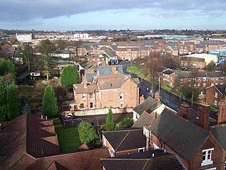
West Bromwich is a market town in the borough of Sandwell, West Midlands, England. Historically part of Staffordshire, it is 7 miles northwest of Birmingham. West Bromwich is part of the area known as the Black Country, in terms of geography, culture and dialect. West Bromwich had a population of 103,112 in the 2021 Census.
Tipton is an industrial town in the Metropolitan Borough of Sandwell in the West Midlands County in England. It had a population of 38,777 at the 2011 UK Census. It is located northwest of Birmingham and southeast of Wolverhampton. It is also contiguous with nearby towns of Darlaston, Dudley, Wednesbury and Bilston.

Sandwell Valley RSPB reserve is a nature reserve, run by the RSPB, in Sandwell Valley, to the north of West Bromwich, in the Sandwell borough of West Midlands in England. It is adjacent to, and shares its main lake with, Sandwell Valley Country Park and near the settlement of Hamstead.
Sandwell is a metropolitan borough of the West Midlands county in England. The borough is named after the Sandwell Priory, and spans a densely populated part of the West Midlands conurbation. Sandwell Metropolitan Borough Council defines the borough as the six amalgamated towns of Oldbury, Rowley Regis, Smethwick, Tipton, Wednesbury and West Bromwich. Rowley Regis includes the towns of Blackheath and Cradley Heath.

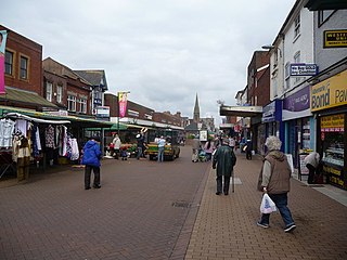
Oldbury is a market town in the Metropolitan Borough of Sandwell, West Midlands, England. It is the administrative centre of the borough. At the 2011 census, the town had a population of 13,606, while the 2017 population of the wider built-up area was estimated at 25,488. Sandwell Metropolitan Borough Council, which defines Oldbury Town as consisting of the wards of Bristnall, Langley, Oldbury, and Old Warley, gave the population as 50,641 in 2011.

The River Tame is a river in the West Midlands of England, and one of the principal tributaries of the River Trent. The Tame is about 95 km (59 mi) long from the source at Oldbury to its confluence with the Trent near Alrewas, but the main river length of the entire catchment, i.e. the Tame and its main tributaries, is about 285 km (177 mi).
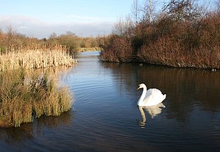
Sandwell Valley Country Park is a country park, run by Sandwell Metropolitan Borough Council, in Sandwell Valley, on the River Tame in the middle of the urban conurbation between Birmingham and West Bromwich in West Midlands, England.
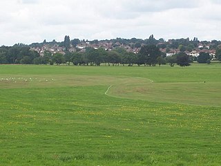
Great Barr is now a large and loosely defined area to the north-west of Birmingham, England. The area was historically in Staffordshire, and the parts now in Birmingham were once known as Perry Barr, which is still the name of an adjacent Birmingham district. Other areas known as Great Barr are in the Metropolitan Boroughs of Walsall and Sandwell.
Perry Hall Park or Perry Hall Country Park, and previously Perry Hall Playing Fields, is a park in Perry Barr, Birmingham, England, at grid reference SP059918. It was in Staffordshire until 1928. The site is protected by Fields in Trust through a legal "Deed of Dedication" safeguarding the future of the space as public recreation land for future generations to enjoy.

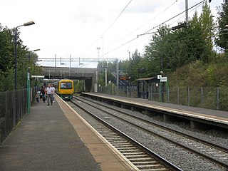
Hamstead railway station serves the Hamstead, Great Barr and Handsworth Wood areas of Birmingham, England. It is located at the junction of Rocky Lane and Old Walsall Road, Hamstead, at Birmingham's border with the borough of Sandwell. It is situated on the Chase Line, part of the former Grand Junction Railway, opened in 1837. The station, and all trains serving it, are operated by West Midlands Trains.
Tame Bridge Parkway is a railway station in the north of the borough of Sandwell, in the West Midlands, England, close to the boundary with Walsall. The station is operated by West Midlands Railway. It is situated on the Chase Line 9 miles (14 km) north of Birmingham New Street, part of the former Grand Junction Railway, opened in 1837.
Hamstead is an area straddling the border of Birmingham and Sandwell, England, between Handsworth Wood and Great Barr, and adjacent to the Sandwell Valley area of West Bromwich. Hamstead Colliery was worked from the 19th century to the 1960s, with much housing built for the miners. Today the area is still referred to as Hamstead Village.

Lodmoor is a Site of Special Scientific Interest (SSSI), RSPB reserve and country park in Dorset, England. The country park features a visitor centre, model railway and pitch and putt golf course. The SSSI has a wetland habitat with native birds that are rare in the UK and a range of migratory species.
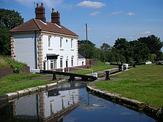
The Tame Valley Canal is a relatively late (1844) canal in the West Midlands of England. It forms part of the Birmingham Canal Navigations. It takes its name from the roughly-parallel River Tame.
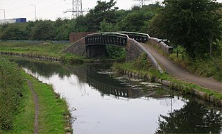
Rushall Junction is the southern limit of the Rushall Canal where it meets the Tame Valley Canal in the West Midlands, England. It opened in 1847, when the Rushall Canal was built to create connections between the Birmingham Canal Navigations system and the Wyrley and Essington Canal, following the amalgamation of the two companies in 1840.

Newton Road railway station was a station of the London and North Western Railway in Sandwell between West Bromwich and Great Barr, England. It lay between Hamstead and the later Tame Bridge Parkway stations on what is now known as the Chase Line.

Forge Mill Lake is a local nature reserve in Sandwell Valley, near West Bromwich in West Midlands, England. It is within Sandwell Valley Country Park.

Sot's Hole is a local nature reserve in West Midlands, England. It is on the west side of Sandwell Valley, and north-east of West Bromwich.
