Sandwell Metropolitan Borough Council

Last updated

Sandwell Metropolitan Borough Council
Coat of arms of Sandwell Metropolitan Borough Council.png
Sandwell MBC logo.svg
Type
Type
Leadership
Syeda Khatun,
Labour
since 21 May 2024 [1]
Kerrie Carmichael,
Labour Party
since 7 December 2021
Shokat Lal
since November 2022 [2]
Structure
Seats72 councillors
Political groups
Administration (64)
  Labour (64)
Other parties (8)
  Conservative (5)
  Independent (3)
Joint committees
West Midlands Combined Authority
Elections
First past the post
Last election
2 May 2024
Next election
7 May 2026
Meeting place
Warley - Sandwell Council House.jpg
Sandwell Council House, Freeth Street, Oldbury, B69 3DB
Website
www.sandwell.gov.uk

Sandwell Metropolitan Borough Council, or Sandwell Council, is the local authority of the Metropolitan Borough of Sandwell in the West Midlands, England. It is a metropolitan borough council and provides the majority of local government services in the borough. The council has been a member of the West Midlands Combined Authority since 2016.

Contents

The council has been under Labour majority control since 1979. It is based at the Council House in Oldbury.

History

The metropolitan district of Sandwell and its council were created in 1974 under the Local Government Act 1972, covering the combined area of the former county boroughs of Warley and West Bromwich, which were both abolished at the same time. [3] It was the second major overhaul of local government structures in the area in eight years; the borough of Warley had only been created in 1966 as a merger of the old boroughs of Oldbury, Rowley Regis and Smethwick, whilst the borough of West Bromwich had been enlarged in 1966 to absorb the area of the abolished boroughs of Tipton and Wednesbury (along with more minor adjustments to the boundaries with other neighbours). [4] [5]

The new district was named Sandwell and it was one of the seven districts in the new metropolitan county of the West Midlands. [6] The first election to the new council was held in 1973. For its first year the council acted as a shadow authority alongside the area's outgoing authorities. The new metropolitan district and its council formally came into being on 1 April 1974, at which point the old districts and their councils were abolished. [3] The metropolitan district was awarded borough status from its creation, allowing the chair of the council to take the title of mayor. [7]

From 1974 until 1986 the council was a lower-tier authority, with upper-tier functions provided by the West Midlands County Council. The county council was abolished in 1986 and its functions passed to the county's seven borough councils, including Sandwell, with some services provided through joint committees. [8]

Since 2016 the council has been a member of the West Midlands Combined Authority, which has been led by the directly elected Mayor of the West Midlands since 2017. The combined authority provides strategic leadership and co-ordination for certain functions across the county, but Sandwell Council continues to be responsible for most local government functions. [9] [10]

In 2022 the government appointed commissioners to oversee the operation of certain functions at the council due to concerns about its performance. The commissioners were withdrawn in 2024 following improvements to the way the council operated. [11]

Governance

Sandwell Council provides metropolitan borough services. Some strategic functions in the area are provided by the West Midlands Combined Authority; the leader and deputy leader of the council sit on the board of the combined authority as Sandwell's representatives. [12] There no civil parishes in the borough. [13]

Political control

The council has been under Labour majority control since 1979.

Political control of the council since 1974 has been as follows: [14] [15]

Party in controlYears
Labour 1974–1978
Conservative 1978–1979
Labour 1979–present

Leadership

The role of mayor is largely ceremonial in Sandwell. Political leadership is instead provided by the leader of the council. The leaders since 1997 have been: [16]

CouncillorPartyFromTo
Tarsem King [17] Labour 19972001
Bill Thomas [18] [19] Labour 200123 Oct 2009
Darren Cooper [20] [21] Labour 1 Dec 200926 Mar 2016
Steve Eling [22] Labour 24 May 201613 Feb 2019
Steve Trow [23] Labour 5 Mar 20193 May 2019
Yvonne Davies Labour 21 May 20198 Jul 2020
Rajbir Singh [24] Labour 25 May 202116 Nov 2021
Kerrie Carmichael Labour 7 Dec 2021

Composition

Following the 2024 election the composition of the council was: [25]

PartyCouncillors
Labour 64
Conservative 5
Independent 3
Total72

The next election is due in May 2026.

Elections

Since the last boundary changes in 2004, the council has comprised 72 councillors representing 24 wards, with each ward electing three councillors. Elections are held three years out of every four, with a third of the council (one councillor for each ward) elected each time for a four-year term of office. [26]

Premises

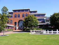
The council's headquarters are at the Council House on Freeth Street in the town centre of Oldbury. The building opened in 1989. [27]

West Bromwich Town Hall: Council's headquarters until 1989 West-bromwich-town-hall.jpg
West Bromwich Town Hall: Council's headquarters until 1989

Prior to 1989, the council met and had its main offices at West Bromwich Town Hall, which had been completed in 1875 and had been the headquarters of the old West Bromwich Borough Council prior to 1974. [28] Additional offices were spread across several buildings, including Smethwick Council House, which had been completed in 1907 for the old Smethwick Borough Council, and had subsequently been the headquarters of the short-lived Warley Borough Council between 1966 and 1974. [29] [30]

Related Research Articles

<span class="mw-page-title-main">West Midlands (county)</span> County of England

West Midlands is a metropolitan and ceremonial county in the larger West Midlands region of England. A landlocked county, it is bordered by Staffordshire to the north and west, Worcestershire to the south, and is surrounded by Warwickshire to the east. The largest settlement is the city of Birmingham.

<span class="mw-page-title-main">Smethwick</span> Town in West Midlands, England

Smethwick is an industrial town in Sandwell, West Midlands, England. It lies 4 miles (6 km) west of Birmingham city centre. Historically it was in Staffordshire and then Worcestershire before being placed into then West Midlands county.

<span class="mw-page-title-main">Sandwell</span> Metropolitan borough in England

Sandwell is a metropolitan borough of the West Midlands county in England. The borough is named after the Sandwell Priory, and spans a densely populated part of the West Midlands conurbation. Sandwell Metropolitan Borough Council defines the borough as the six amalgamated towns of Oldbury, Rowley Regis, Smethwick, Tipton, Wednesbury and West Bromwich. Rowley Regis includes the towns of Blackheath and Cradley Heath.

<span class="mw-page-title-main">Oldbury, West Midlands</span> Town in West Midlands, England

Oldbury is a market town in the Metropolitan Borough of Sandwell, West Midlands, England. It is the administrative centre of the borough. At the 2011 census, the town had a population of 13,606, while the 2017 population of the wider built-up area was estimated at 25,488. Sandwell Metropolitan Borough Council, which defines Oldbury Town as consisting of the wards of Bristnall, Langley, Oldbury, and Old Warley, gave the population as 50,641 in 2011.

<span class="mw-page-title-main">Rowley Regis</span> Human settlement in England

Rowley Regis is a town and former municipal borough in Sandwell in the county of the West Midlands, England. It forms part of the area immediately west of Birmingham known as the Black Country and encompasses the three Sandwell council wards of Blackheath, Cradley Heath and Old Hill, and Rowley. At the 2011 census, the combined population of these wards was 50,257.

<span class="mw-page-title-main">Blackheath, West Midlands</span> Human settlement in England

Blackheath is a town in the Sandwell Metropolitan Borough, in the county of West Midlands, England.

<span class="mw-page-title-main">County Borough of Warley</span>

Warley was a short-lived county borough and civil parish in the geographical county of Worcestershire, England, forming part of the West Midlands conurbation. It was formed in 1966 by the combination of the existing county borough of Smethwick with the municipal boroughs of Oldbury and Rowley Regis, by recommendation of the Local Government Commission for England. It was abolished just 8 years later in 1974 under the Local Government Act 1972, with its area passing to the Metropolitan Borough of Sandwell.

<span class="mw-page-title-main">Brandhall</span> Human settlement in England

Brandhall is a suburb of Oldbury in the south of the Metropolitan Borough of Sandwell, West Midlands, bordering Birmingham and Halesowen. The development of the area commenced during the 1930s with the construction of several hundred private houses along the Hagley Road and Wolverhampton Road, as well as several side roads leading off the main dual carriageways. Oldbury Corporation founded a municipal farm in 1943. In 1949, the farm included a piggery, and fields growing wheat, potatoes, barley, hay, clover and oats. Oldbury Council placed a public notice for the demolition and removal of the farm buildings in February 1952. Most of Brandhall was developed in the 1950s and 1960s, when several thousand council houses, flats and bungalows were built by Oldbury Council on farmland to the south of Brand Hall. The Hall, which had become the clubhouse for Brandhall Golf Course, was demolished. Some of the first families moving on to the estate were relocating from Smethwick. Most of the high and medium-rise flats in Brandhall were demolished in the early 2000s and in their place housing associations built new low-rise homes.

<span class="mw-page-title-main">Halesowen and Rowley Regis (UK Parliament constituency)</span> Parliamentary constituency in the United Kingdom, 1997 onwards

Halesowen and Rowley Regis is a constituency in the West Midlands represented in the House of Commons of the UK Parliament since 2010 by James Morris, a Conservative.

<span class="mw-page-title-main">Warley (UK Parliament constituency)</span> Parliamentary constituency in the United Kingdom, 1997 onwards

Warley was a constituency in the House of Commons of the UK Parliament. The constituency was represented since its creation in 1997 by John Spellar, a member of the Labour Party.

<span class="mw-page-title-main">Warley, West Midlands</span>

Warley is a residential area of Oldbury in the Metropolitan Borough of Sandwell in the West Midlands of the United Kingdom. Historically in both Worcestershire and Shropshire, the name has been used for both a civil parish (1884–1908) and a county borough (1966–1974). Warley has been the name of a UK Parliament constituency since 1997.

Warley West was a parliamentary constituency in the borough of Sandwell in the West Midlands of England. It was initially centred on the towns of Rowley Regis and Cradley Heath, and from 1983 also incorporated parts of Oldbury.

<span class="mw-page-title-main">West Bromwich (UK Parliament constituency)</span> Parliamentary constituency in the United Kingdom, 1885–1974

West Bromwich was a borough constituency represented in the House of Commons of the Parliament of the United Kingdom from 1885 until 1974. It centred on West Bromwich, in the West Midlands. It elected one Member of Parliament (MP) by the first past the post voting system.

Galton Village is a residential area of Smethwick, West Midlands, England. It takes its name from the iconic Galton Bridge that was named after local businessman Samuel Galton. The Birmingham Canal Navigations main line to Wolverhampton borders the north of Galton Village, as does the Stour Valley section of the West Coast Mainline. The Oldbury Road A457 runs through the area, which begins next to Smethwick’s Galton Bridge railway station and ends at Spon Lane, at a small shopping centre.

Warley College, originally called Warley College of Technology, was a college of further and higher education which served the vicinity of Oldbury in the West Midlands of England. It was formed in 1968 by the amalgamation of Oldbury College of Further Education and Chance Technical College in Smethwick and named in accordance with the recently created County Borough of Warley. It was located on the main Wolverhampton – Birmingham road.

<span class="mw-page-title-main">Evolution of Worcestershire county boundaries since 1844</span>

The administrative boundaries of Worcestershire, England have been fluid for over 150 years since the first major changes in 1844. There were many detached parts of Worcestershire in the surrounding counties, and conversely there were islands of other counties within Worcestershire. The 1844 Counties Act began the process of eliminating these, but the process was not completed until 1966, when Dudley was absorbed into Staffordshire.

<span class="mw-page-title-main">Shropshire (Detached)</span> Shropshire exclave of Halesowen and Oldbury

Between the late 11th century and 1844, the English county of Shropshire possessed a large exclave within the present-day Black Country and surrounding area. This territory was gained from neighbouring Worcestershire, and the exclave's border corresponded with the medieval Manor of Hala. Shropshire (Detached) contained the townships of Halesowen, Oldbury, Warley Salop, Ridgacre, Hunnington, Romsley and Langley. The exceptions were Cradley, Lutley and Warley Wigorn, which were exclaves or enclaves still aligned with the original county. Bounded entirely by Staffordshire and Worcestershire, Hala was part of Brimstree hundred, and totally detached from the rest of Shropshire. Bridgnorth, the nearest town within the main body of Shropshire, is 16.8 miles (27.03 km) away from Halesowen, whilst the county town of Shrewsbury is 34.6 miles (55.62 km) away.

<span class="mw-page-title-main">Sandwell Community History and Archives Service</span>

Sandwell Community History and Archives Service (CHAS) is the archive service for the Metropolitan Borough of Sandwell in the West Midlands of England. The service is based within Smethwick Library. It collects and preserves original archives and published material relating to the history of Sandwell. It is a local authority archive service, run and funded by Sandwell Metropolitan Borough Council.

<span class="mw-page-title-main">Municipal Buildings, Oldbury</span> Municipal building in Oldbury, West Midlands, England

The Municipal Buildings are in Oldbury town centre, West Midlands, England. The structure served as the headquarters of Oldbury Borough Council.

References

  1. Barnett, Christian (22 May 2024). "First female Muslim mayor appointed by council". BBC News. Retrieved 11 June 2024.
  2. "Sandwell Council appoints new chief executive". BBC News. 9 November 2022. Retrieved 15 June 2023.
  3. 1 2 "Local Government Act 1972: Schedule 1", legislation.gov.uk , The National Archives, 1972 c. 70 (sch.1), retrieved 30 May 2024
  4. "West Bromwich Municipal Borough / County Borough". A Vision of Britain through Time. GB Historical GIS / University of Portsmouth. Retrieved 11 June 2024.
  5. "Warley County Borough". A Vision of Britain through Time. GB Historical GIS / University of Portsmouth. Retrieved 11 June 2024.
  6. "The Metropolitan Districts (Names) Order 1973", legislation.gov.uk , The National Archives, SI 1973/137, retrieved 11 June 2024
  7. "District Councils and Boroughs". Parliamentary Debates (Hansard) . 28 March 1974. Retrieved 30 May 2024.
  8. "Local Government Act 1985", legislation.gov.uk , The National Archives, 1985 c. 51, retrieved 5 April 2024
  9. "The West Midlands Combined Authority Order 2016", legislation.gov.uk , The National Archives, SI 2016/653, retrieved 11 June 2024
  10. "Understand how your council works". gov.uk. Retrieved 30 May 2024.
  11. Dawkins, Andrew (7 March 2024). "Government ends intervention at council". BBC News. Retrieved 11 June 2024.
  12. "Contact details WMCA Board". West Midlands Combined Authority. Retrieved 11 June 2024.
  13. "Election Maps". Ordnance Survey. Retrieved 30 May 2024.
  14. "Compositions calculator". The Elections Centre. Retrieved 9 September 2022.
  15. "Sandwell". BBC News Online . 19 April 2008. Retrieved 3 October 2009.
  16. "Council minutes". Sandwell Metropolitan Borough Council. Retrieved 12 September 2022.
  17. "Tributes paid to former Sandwell Council leader". Birmingham Mail. 10 January 2013. Retrieved 12 September 2022.
  18. "Council leader resigns over theft charge". Halesowen News. 23 October 2009. Retrieved 12 September 2022.
  19. "Former Sandwell Council leader Bill Thomas OBE dies in Wales". Halesowen News. 26 March 2010. Retrieved 12 September 2022.
  20. "Sandwell council leader Darren Cooper dies aged 52". ITV News. 27 March 2016. Retrieved 12 September 2022.
  21. "Sandwell Council leader Darren Cooper dies – BBC News". BBC. 27 March 2016. Retrieved 19 September 2016.
  22. "Steve Eling resigns as Sandwell Council leader". Halesowen News. 14 February 2019. Retrieved 14 February 2019.
  23. "Statement of Accounts 2018/19". Sandwell Metropolitan Borough Council. 30 September 2020. p. 14. Retrieved 12 September 2022.
  24. Madeley, Peter (16 November 2021). "Sandwell Council leader steps down after six months in role". Express and Star. Retrieved 12 September 2022.
  25. "Local elections 2024: full mayoral and council results for England". The Guardian. 4 May 2024. Retrieved 21 May 2024.
  26. "The Borough of Sandwell (Electoral Changes) Order 2003", legislation.gov.uk , The National Archives, SI 2003/2510, retrieved 11 June 2024
  27. "Sandwell Council House - Sandwell Council House Freeth Street Oldbury UK Oldbury, B69 3DE England - Administrative | Honest Buildings". Archived from the original on 6 June 2014. Retrieved 2 June 2014.
  28. Historic England. "Town Hall, High Street (Grade II) (1077117)". National Heritage List for England . Retrieved 11 June 2024.
  29. Historic England. "Council House, High Street (Grade II) (1342665)". National Heritage List for England . Retrieved 11 June 2024.
  30. Municipal Year Book. Municipal Journal. 1976. p. 858.