County Borough of Warley

Last updated

Warley
County borough
Warley map.png
Map of Warley County Borough
Area
  19663,833 acres (15.51 km2)
  19743,833 acres (15.51 km2)
Population
  1971163,545
History
  Preceded byCounty Borough of Smethwick
Municipal Borough of Oldbury
Municipal Borough of Rowley Regis
  Origin Local Government Act 1958
  Created1966
  Abolished1974
  Succeeded by Sandwell
Status County borough, Civil parish
Government
   HQ Smethwick Council House, Smethwick
   Motto Unity and Progress
Warley-arms.png
Arms of the County Borough of Warley

Warley was a short-lived county borough and civil parish in the geographical county of Worcestershire, England, forming part of the West Midlands conurbation. [1] It was formed in 1966 by the combination of the existing county borough of Smethwick with the municipal boroughs of Oldbury and Rowley Regis, by recommendation of the Local Government Commission for England. [1] It was abolished just 8 years later in 1974 under the Local Government Act 1972, with its area passing to the Metropolitan Borough of Sandwell.

Contents

Formation

The local government structure within North Worcestershire and South Staffordshire - Prior to the West Midlands Order 1965 reorganisation The local government structure within the Black Country (Pre-1966).png
The local government structure within North Worcestershire and South Staffordshire – Prior to the West Midlands Order 1965 reorganisation

The Local Government Act 1958 appointed a Local Government Commission to review administrative structures and boundaries in England outside London. The Act designated a "West Midlands Special Review Area" as one of five conurbations in which urgent reform was felt to be needed. [2] The commission made its report in July 1961, recommending that the Black Country area of the West Midlands should be administered by five large county boroughs. The proposal to merge the boroughs of Oldbury, Rowley Regis and Smethwick as one of the new authorities was initially suggested by the three councils involved. The government announced that it accepted the proposals in November 1962, and it was originally intended that the County Borough of Warley should come into being on 1 April 1964. [3] The reforms were delayed when five district councils in the review area took legal action in an attempt to prevent their implementation. The legal process was finally concluded in the Court of Appeal in July 1965, with the court ruling in the government's favour. Plans for Rowley Regis to be absorbed into an expanded Dudley borough were also considered, while Halesowen was being lined up as the third area to be absorbed into a new borough which also included Oldbury and Smethwick, but this did not happen and the borough of Halesowen survived until it was incorporated into the new Metropolitan Borough of Dudley in 1974. [3]

The Local Government (West Midlands) Order 1965 was made on 3 November 1965, with the changes to come into effect on 1 April 1966. The Order was debated in the House of Commons on 2 December 1965. John Horner, the Labour MP for Oldbury and Halesowen stated that while the boroughs of Oldbury and Rowley Regis had supported the creation of the new county borough in 1961, they no longer did so. In contrast, Peter Griffiths, Conservative member for Smethwick stated that the working party consisting of councillors for the three boroughs had given up their opposition, and were trying to make a success of the new county borough. The group did, however, have objections to boundary changes which caused the transfer of an estate of council houses (next to the West Bromwich Albion F.C. stadium) to West Bromwich. [3]

The borough took its name from the ancient Manor of Warley, listed in the Domesday Survey as covering much of the area. This was subsequently divided into two parts: Warley Salop (in Shropshire) and Warley Wigorn (in Worcestershire). This was united as the civil parish of Warley in 1884, but later divided between the boroughs of Oldbury and Smethwick (Warley Woods). [1] [4]

Smethwick and Rowley Regis had been part of Staffordshire, while Oldbury was part of Worcestershire (having been transferred from Shropshire in 1844). The new county borough was placed entirely in the geographical county of Worcestershire. Part of the Oakham area of Dudley and most of the Tividale area of Tipton were also incorporated into Warley, becoming part of the new Oldbury B69 postal district.

The archives for Warley Borough are held at Sandwell Community History and Archives Service.

Areas transferred

Existing local authorityArea (acres)Population 1961Notes
Rowley Regis MB, Staffordshire1,48347,831Remainder of borough was divided between West Bromwich CB (44 acres, pop 43)
and Halesowen MB (2 acres, pop 150)
Oldbury MB, Worcestershire1,23151,902Remainder of borough was divided between West Bromwich CB (11 acres, pop 43)
and Halesowen MB (95 acres, pop 2,003)
Smethwick CB98867,501Remainder of borough was divided between West Bromwich CB (20 acres, pop 889)
and Birmingham CB (3 acres, pop 0)
Birmingham CB501,820
Halesowen MB, Worcestershire37525
West Bromwich CB32169
Dudley CB10317
Tipton MB, Staffordshire195Borough was abolished, the remainder becoming part of West Bromwich CB with the exception of a small section being incorporated into Dudley CB
Brierley Hill UD, Staffordshire10Urban District was abolished, most going to Dudley CB

Source:Vision of Britain [5]

On creation, the county borough was included in the area of the West Midlands Constabulary, which was formed to cover the five Black Country county boroughs formed in 1966. Warley was included in the area of the West Midlands Passenger Transport Executive in 1969, and nominated one member of the transport authority. [6]

Borough council

The first elections to Warley Borough Council were in February 1966, with those elected being a "shadow council" until coming into full powers on 1 April. [3] The Labour Party initially held power, losing it to the Conservatives in 1968. Labour regained control in 1972 at the final borough election before abolition. The county borough was divided into fifteen wards, each returning three councillors and one alderman: [1]

The political composition of the borough council was as follows following each election from 1967 to 1972:

YearLabourConservative Liberal Independent
1967 [7] 312612
1968 [8] 173913
1969 [9] 104712
1970 [10] 174110
1971 [11] 263211
1972 [12] 392100

In 1967, the first council elections in Warley saw the Labour Party gain control of the council with a narrow majority, although the following year saw the Conservatives gain control with a significant majority, reflecting the slump in popularity of the Labour government across Britain at the time. In 1972, Labour regained control of Warley.

In September 1967, the council appointed Tony O'Connor as headmaster at what was then Bearwood Junior and Infants School; he is widely held to be the UK's first black headmaster. [13]

Coat of arms

On 30 June 1966, the College of Arms granted the new county borough armorial bearings. [14] The design incorporated features from the arms of the three merged boroughs. The blazon of the arms was as follows:

Per saltire vert and or, two lions rampant in pale or, in fess of either flank a club in bend sinister surmounted by a caduceus in bend proper; on a chief or a lion passant vert. And for a crest: Issuant from a Saxon crown or, a demi lion rampant double queued vert holding with the dexter paw an arrow barb downwards proper. Supporters: on the dexter side a lion gules in the mouth an arrow proper; on the sinister side a dragon gules in the mouth an anchor or. [14]

The "chief" or upper third of the shield bearing a lion passant came from the arms of Rowley Regis, and the "per saltire" division of the arms and green and gold colouring was found in Oldbury's insignia. The gold lions on a green background were from the arms of the Robsart family, while the crossed club and caduceus were the arms of James Watt. The crest featured a Saxon crown from which rose a green double-tailed lion, emblem of the Suttons, mediaeval lords of Dudley. The lion held an arrow from the arms of Matthew Boulton. The supporters of the arms were a red lion and dragon. The lion was from the armorial bearings of Sir James Timmins Chance, while the dragon was intended to represent the ancient Britons, founders of the "old burh" or Oldbury. Both animals held objects in their mouths as heraldic differences: an arrow (as in the crest) and an anchor (for Cradley Heath's traditional industry). The motto chosen by the borough was "Unity and Progress". [15]

Parliamentary constituencies

The Parliamentary Constituencies (England) Order 1970 divided the county borough into two parliamentary constituencies: Warley East and Warley West. [16] The constituencies were first used at the 1974 general election, shortly before the abolition of the borough. They were abolished in 1997, although the borough's name lives on in the modern Warley constituency which consists of Oldbury and Smethwick (formerly Warley East). The old Warley West seat was divided between the new constituency of Halesowen and Rowley Regis and an expanded West Bromwich West.

Abolition

On the formation of the West Midlands metropolitan county in 1974, the county borough of Warley merged with the county borough of West Bromwich to form the Metropolitan Borough of Sandwell. West Bromwich itself had expanded in 1966 to take in the bulk of Tipton and Wednesbury. [17]

Related Research Articles

<span class="mw-page-title-main">West Midlands (county)</span> County of England

West Midlands is a metropolitan and ceremonial county in the larger West Midlands region of England. A landlocked county, it is bordered by Staffordshire to the north and west, Worcestershire to the south, and is surrounded by Warwickshire to the east. The largest settlement is the city of Birmingham.

<span class="mw-page-title-main">Smethwick</span> Town in West Midlands, England

Smethwick is an industrial town in Sandwell, West Midlands, England. It lies 4 miles (6 km) west of Birmingham city centre. Historically it was in Staffordshire and then Worcestershire before being placed into then West Midlands county.

<span class="mw-page-title-main">Sandwell</span> Metropolitan borough in England

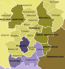
Sandwell is a metropolitan borough of the West Midlands county in England. The borough is named after the Sandwell Priory, and spans a densely populated part of the West Midlands conurbation. Sandwell Metropolitan Borough Council defines the borough as the six amalgamated towns of Oldbury, Rowley Regis, Smethwick, Tipton, Wednesbury and West Bromwich. Rowley Regis includes the towns of Blackheath and Cradley Heath.
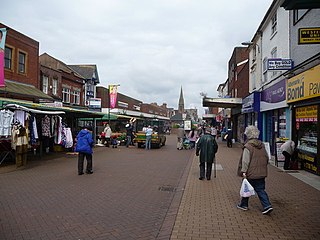
<span class="mw-page-title-main">Oldbury, West Midlands</span> Town in West Midlands, England

Oldbury is a market town in the Metropolitan Borough of Sandwell, West Midlands, England. It is the administrative centre of the borough. At the 2011 census, the town had a population of 13,606, while the 2017 population of the wider built-up area was estimated at 25,488. Sandwell Metropolitan Borough Council, which defines Oldbury Town as consisting of the wards of Bristnall, Langley, Oldbury, and Old Warley, gave the population as 50,641 in 2011.

<span class="mw-page-title-main">Rowley Regis</span> Human settlement in England

Rowley Regis is a town and former municipal borough in Sandwell in the county of the West Midlands, England. It forms part of the area immediately west of Birmingham known as the Black Country and encompasses the three Sandwell council wards of Blackheath, Cradley Heath and Old Hill, and Rowley. At the 2011 census, the combined population of these wards was 50,257.

<span class="mw-page-title-main">Blackheath, West Midlands</span> Human settlement in England

Blackheath is a town in the Sandwell Metropolitan Borough, in the county of West Midlands, England.

The West Midlands region straddles the historic borders between the counties of Warwickshire, Staffordshire in the north, and Worcestershire in the south.

<span class="mw-page-title-main">Brandhall</span> Human settlement in England

Brandhall is a suburb of Oldbury in the south of the Metropolitan Borough of Sandwell, West Midlands, bordering Birmingham and Halesowen. The development of the area commenced during the 1930s with the construction of several hundred private houses along the Hagley Road and Wolverhampton Road, as well as several side roads leading off the main dual carriageways. Oldbury Corporation founded a municipal farm in 1943. In 1949, the farm included a piggery, and fields growing wheat, potatoes, barley, hay, clover and oats. Oldbury Council placed a public notice for the demolition and removal of the farm buildings in February 1952. Most of Brandhall was developed in the 1950s and 1960s, when several thousand council houses, flats and bungalows were built by Oldbury Council on farmland to the south of Brand Hall. The Hall, which had become the clubhouse for Brandhall Golf Course, was demolished. Some of the first families moving on to the estate were relocating from Smethwick. Most of the high and medium-rise flats in Brandhall were demolished in the early 2000s and in their place housing associations built new low-rise homes.

<span class="mw-page-title-main">Halesowen and Rowley Regis (UK Parliament constituency)</span> Parliamentary constituency in the United Kingdom, 1997 onwards

Halesowen and Rowley Regis is a constituency in the West Midlands represented in the House of Commons of the UK Parliament since 2010 by James Morris, a Conservative.

<span class="mw-page-title-main">Warley (UK Parliament constituency)</span> Parliamentary constituency in the United Kingdom, 1997 onwards

Warley is a constituency in the House of Commons of the UK Parliament. The constituency was established in 1997, and has been represented since that date by John Spellar, a member of the Labour Party.

<span class="mw-page-title-main">County Borough of Dudley</span>

The County Borough of Dudley was a local government district in the English Midlands from 1865 to 1974. Originally a municipal borough, it became a county borough in 1889, centred on the main town centre of Dudley, along with the suburbs of Netherton and Woodside. Although surrounded by Staffordshire, the borough was associated with Worcestershire for non-administrative purposes, forming an exclave of the county until 1966, when it was transferred to Staffordshire after an expansion of the borough boundaries. Following local government reorganization in 1974, Dudley took in the boroughs of Halesowen and Stourbridge to form the present-day Metropolitan Borough of Dudley, in the newly formed West Midlands county.

<span class="mw-page-title-main">Warley, West Midlands</span>

Warley is a residential area of Oldbury in the Metropolitan Borough of Sandwell in the West Midlands of the United Kingdom. Historically in both Worcestershire and Shropshire, the name has been used for both a civil parish (1884–1908) and a county borough (1966–1974). Warley has been the name of a UK Parliament constituency since 1997.

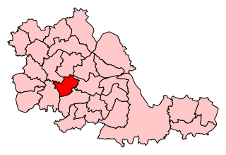
Warley West was a parliamentary constituency in the borough of Sandwell in the West Midlands of England. It was initially centred on the towns of Rowley Regis and Cradley Heath, and from 1983 also incorporated parts of Oldbury.

West Bromwich was a borough constituency represented in the House of Commons of the Parliament of the United Kingdom from 1885 until 1974. It centred on West Bromwich, in the West Midlands. It elected one Member of Parliament (MP) by the first past the post voting system.

This article details a number of defunct schools that were once located in Sandwell in the West Midlands of England. For details of currently operating schools in Sandwell, please see: List of schools in Sandwell.

<span class="mw-page-title-main">Evolution of Worcestershire county boundaries since 1844</span>

The administrative boundaries of Worcestershire, England have been fluid for over 150 years since the first major changes in 1844. There were many detached parts of Worcestershire in the surrounding counties, and conversely there were islands of other counties within Worcestershire. The 1844 Counties Act began the process of eliminating these, but the process was not completed until 1966, when Dudley was absorbed into Staffordshire.

<span class="mw-page-title-main">Shropshire (Detached)</span> Shropshire exclave of Halesowen and Oldbury

Between the late 11th century and 1844, the English county of Shropshire possessed a large exclave within the present-day Black Country and surrounding area. This territory was gained from neighbouring Worcestershire, and the exclave's border corresponded with the medieval Manor of Hala. Shropshire (Detached) contained the townships of Halesowen, Oldbury, Warley Salop, Ridgacre, Hunnington, Romsley and Langley. The exceptions were Cradley, Lutley and Warley Wigorn, which were exclaves or enclaves still aligned with the original county. Bounded entirely by Staffordshire and Worcestershire, Hala was part of Brimstree hundred, and totally detached from the rest of Shropshire. Bridgnorth, the nearest town within the main body of Shropshire, is 16.8 miles (27.03 km) away from Halesowen, whilst the county town of Shrewsbury is 34.6 miles (55.62 km) away.

<span class="mw-page-title-main">Municipal Buildings, Oldbury</span> Municipal building in Oldbury, West Midlands, England

The Municipal Buildings are in Oldbury town centre, West Midlands, England. The structure served as the headquarters of Oldbury Borough Council.

Halesowen is a proposed constituency of the House of Commons in the UK Parliament. Further to the completion of the 2023 Periodic Review of Westminster constituencies, it will first be contested at the next general election. The constituency is named after the town of Halesowen.

References

  1. 1 2 3 4 Frederic A. Youngs, Jr., Guide to the Local Administrative Units of England, Vol.II: Northern England, London, 1991
  2. Local Government Act 1958 c.55
  3. 1 2 3 4 "Local Government (West Midlands Order) HC Deb 02 December 1965 vol 721 cc1793-846". Parliamentary Debates (Hansard) . 2 December 1965. Retrieved 3 June 2008.
  4. "Manors: Halesowen: Introduction, borough and manors in A History of the County of Worcester, Vol.3". British History Online. 1913. Retrieved 3 June 2008.
  5. "Warley County Borough". Vision of Britain. Retrieved 4 June 2008.
  6. The West Midlands Passenger Transport Area (Designation) Order 1969 (S.I. 1969 No. 97)
  7. The Times, 12 May 1967
  8. The Times, 10 May 1968
  9. The Times, 12 May 1969
  10. The Times, 8 May 1970
  11. The Times, 14 May 1971
  12. The Times, 5 May 1972
  13. "England's pioneering black head teachers". BBC News. 11 May 2018. Retrieved 30 November 2020.
  14. 1 2 Geoffrey Briggs, Civic & Corporate Heraldry: A dictionary of impersonal arms of England, Wales and Northern Ireland, London, 1971
  15. Peter Skidmore, The Civic Heraldry of the Black Country, Kingswinford, 2003
  16. The Parliamentary Constituencies (England) Order 1970 (S.I. 1970 No. 1674)
  17. "About Sandwell | Sandwell Homes". Archived from the original on 15 June 2012. Retrieved 8 May 2012.

52°30′N2°00′W / 52.5°N 2.0°W / 52.5; -2.0