This article needs additional citations for verification .(January 2016) |
Essington | |
---|---|
Village and civil parish | |
Location within Staffordshire | |
Population | 5,200 (2021) [1] |
OS grid reference | SJ962034 |
Civil parish |
|
District | |
Shire county | |
Region | |
Country | England |
Sovereign state | United Kingdom |
Post town | Wolverhampton |
Postcode district | WV11 |
Dialling code | 01922 |
Police | Staffordshire |
Fire | Staffordshire |
Ambulance | West Midlands |
UK Parliament | |
Essington is a village and civil parish in the South Staffordshire, district, in Staffordshire, England, near the city of Wolverhampton and towns of Walsall, Bloxwich, Cannock and Brewood. The villages of Cheslyn Hay, Great Wyrley, Coven, Penkridge and Featherstone are also nearby. The village forms part of the Staffordshire/West Midlands border. The parish includes the hamlet of Springhill. In 2021 the parish had a population of 5,200.
In 1870-1872 the Imperial Gazetteer of England and Wales described Essington as a township in the parish of Bushbury, with a post office and 187 houses. The population had risen from 644 in 1851 to 976 in 1861, "from the extension of mining operations", and an iron church with room for 260 people had been built in 1858–1859. [2]
Essington is home to the remains of several moated farmsteads, possibly of Iron Age origin, on the land adjacent to the village's current boundaries. There is a public park called Brownshore Lakes, which is the site of two adjacent lakes. They are the remains of three coal mining tailing and settling ponds. The lakes are surrounded by woodland and it is a local recreational meeting place. It is also home to waterfowl and there is also an abundance of other wildlife around the lakes and the woods.
The village has direct connections with 2 main major roads: the A462, which runs from Junction 11 of the M6 to Wednesbury, West Midlands, and the A460 that links Wolverhampton with Cannock and Rugeley. The M6 and M54 motorways meet just northeast of the village, and are both accessible via the A460.
While the village was once served by several bus routes, now the only service to Essington is route 71. The service runs hourly to Cannock throughout the day Monday to Saturday, and continues from St Johns Church to New Cross Hospital and Wolverhampton until early afternoon Monday to Friday. Service 71 is operated by Chaserider (previously operated by Select Bus and Arriva). The nearest railway station is Bloxwich North, a 35-minute walk away.
The Parish of Essington is quite large encompassing a village a number of recreational, industrial and farming areas and several hamlets and is part of South Staffordshire district in Staffordshire. It borders the county of West Midlands (Walsall and Wolverhampton). The Health Authority is South Staffordshire, the Ambulance Service is West Midlands, Social Services are South Staffordshire in Codsall. All property taxes (rates) are collected by South Staffordshire at Codsall.
Essington Parish Council is the lowest tier of local government. [3] [4]
Westcroft, a residential area along the A460 road in the west of the parish, borders the Wolverhampton suburb of Underhill. [5]
The main school in Essington is St Johns Primary Academy. [6] Located on Hobnock Road, it was built in 1846 and became known as St John's Church of England School from 1968.
Brownshore Pre-School Play Group is located opposite St John's Primary School on Hobnock Road.
Essington is a main catchment area for Cheslyn Hay Academy students.
There are rugby and football facilities in several locations around the parish located at Essington Rugby Club, High Hill, Essington.
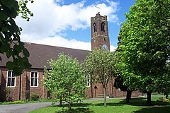
St John's Anglican church is in the village and has many activities during the day and sometimes in the evening. [7] It was built in 1932 and has an extension at the west end, completed in 2015. [8] Outside the village, Essington Wood Methodist Chapel is Bursnips Road (A462). [9]
South Staffordshire is a local government district in Staffordshire, England. Its council is based in Codsall. Other notable settlements include Brewood, Cheslyn Hay, Coven, Essington, Featherstone, Four Ashes, Great Wyrley, Huntington, Kinver, Landywood, Penkridge, Perton, Wedges Mills, Weston-under-Lizard and Wombourne. The district covers a largely rural area lying immediately to the west and north-west of the West Midlands conurbation.
The Metropolitan Borough of Walsall is a metropolitan borough in the West Midlands, England. It is named after its largest settlement, Walsall, but covers a larger area which also includes Aldridge, Bloxwich, Brownhills, Darlaston, Pelsall and Willenhall.
Wednesfield is a town and historic village in the City of Wolverhampton, in the county of the West Midlands, England, It is 2 miles (3.2 km) east-northeast of Wolverhampton city centre and about 10 miles (16 km) from Birmingham and is part of the West Midlands conurbation. It was historically within the county of Staffordshire.
Codsall is a village and civil parish in the South Staffordshire district of Staffordshire, England. It is situated 5 miles northwest of Wolverhampton and 13 miles east-southeast of Telford. It forms part of the boundary of the Staffordshire-West Midlands County border, along with Perton, the village is almost contiguous with Wolverhampton with very small amounts of greenbelt still separating the two settlements.
The Chase Line is a suburban railway line in the West Midlands region of England. It runs from its southern terminus, Birmingham New Street, to Walsall, and then Rugeley Trent Valley in Staffordshire, where it joins the Trent Valley line. The name of the line refers to Cannock Chase which it runs through at its northern end.
Great Wyrley is a village and civil parish in the South Staffordshire district of Staffordshire, England. It forms a built-up area with nearby Cheslyn Hay, Churchbridge, Landywood and Little Wyrley. It lies 6 miles (9.7 km) north of Walsall and a similar distance from Wolverhampton. Cannock is directly north of the village. It had a population of 11,060 at the 2011 census.
New Invention is a large estate around three miles (4.8 km) north of the town of Willenhall and four miles (6.4 km) east of the city of Wolverhampton in the Metropolitan Borough of Walsall, West Midlands, England. It is halfway between Walsall and Wolverhampton on the busy main A4124 and A462 roads.
Pelsall is a village in the Metropolitan Borough of Walsall, West Midlands, England. Forming part of the borough's border with Staffordshire, Pelsall is located 4 miles north of Walsall, midway between the towns of Bloxwich and Brownhills and 4 miles northwest of Aldridge. The southern edge of Cannock Chase is 6 miles to the north. Pelsall is also 8 miles southwest of Lichfield and 8 miles northeast of Wolverhampton.
The River Penk is a small river flowing through Staffordshire, England. Its course is mainly within South Staffordshire, and it drains most of the northern part of that district, together with some adjoining areas of Cannock Chase, Stafford, Wolverhampton, and Shropshire. It flows into the River Sow, which is a tributary of the River Trent, so its waters flow ultimately into the North Sea via the Humber Estuary.
Bentley is an area in the Walsall district, in the county of the West Midlands, England, located around Junction 10 of the M6 Motorway. It is also a rural village of houses towards its eastern sides. It shares borders with the areas of Willenhall, Beechdale, Ashmore Park, Pleck, Darlaston and Alumwell.
Landywood is an area of Great Wyrley in the South Staffordshire district of Staffordshire, England. Landywood is part of the South Staffordshire ward named "Great Wyrley Landywood", It lies 3 miles (4.8 km) north of Bloxwich, 3 miles (4.8 km) south from Cannock and 6 miles (9.7 km) north of Walsall.
Landywood railway station is situated in the village of Landywood in Staffordshire, England. As well as Landywood, the station also serves the adjacent villages of Cheslyn Hay and Great Wyrley. The LNWR also operated an earlier halt at Landywood which closed on 1 January 1916.
Cheslyn Hay is a former mining village and civil parish in the South Staffordshire district of Staffordshire, England. It is 3 miles south of Cannock, 10 miles north of Walsall, 9 miles northeast of Wolverhampton, and 13 miles south of Stafford. The village forms a built-up area with the villages and areas of Great Wyrley, Landywood, and Churchbridge.
The A460 is a main road in the Midlands of England. It runs from Wolverhampton in the West Midlands to Rugeley in Staffordshire. It is also a primary road linking Wolverhampton and Cannock with the M54, M6 and M6 Toll.
Rushall is a historic village in the Metropolitan Borough of Walsall in the West Midlands county of England. It is centred on the main road between Walsall and Lichfield. It is mentioned in the Domesday Book but has mostly developed since the 1920s. Rushall was historically a part of the county of Staffordshire before it was incorporated with much of the old Aldridge-Brownhills Urban District into the modern-day Walsall district.
Norton Canes is a village and civil parish in the Cannock Chase District, in Staffordshire, England. It lies close to the borders of the Lichfield, South Staffordshire and Walsall districts.
Short Heath is a residential area situated north of the market town of Willenhall, in the Walsall district, in the county of the West Midlands, England. Short Heath is a ward in the Walsall North constituency, and is bordered by the neighbouring wards of Bentley and Darlaston North, Birchills Leamore, Willenhall North, and Willenhall South.
The Staffordshire Rugby Union is the governing body for the sport of rugby union in the county of Staffordshire in England. The union is the constituent body of the Rugby Football Union (RFU) for Staffordshire, and administers and organises rugby union clubs and competitions in the county. It also administers the Staffordshire county rugby representative teams.
Chaserider is the brand name for bus services operated around Cannock and Staffordshire by D&G Bus, a local bus operator owned by Centrebus who are based in Adderley Green, Stoke-on-Trent, Staffordshire.
Upper Landywood is a suburb of Great Wyrley in South Staffordshire district of the county of Staffordshire, England.