Related Research Articles
Penkridge is a large village and civil parish in South Staffordshire District in Staffordshire, England. It is to the south of Stafford, north of Wolverhampton, west of Cannock and east of Telford.

Edward John Littleton, 1st Baron Hatherton PC, FRS, was a British politician from the extended Littleton/Lyttelton family, of first the Canningite Tories and later the Whigs. He had a long political career, active in each of the Houses of Parliament in turn over a period of forty years. He was closely involved in a number of major reforms, particularly Catholic Emancipation, the Truck Act of 1831, the Parliamentary Boundaries Act 1832 and the Municipal Corporations Act 1835. Throughout his career he was actively concerned with the Irish question and he was Chief Secretary for Ireland between 1833 and 1834.
Stafford is a constituency represented in the House of Commons of the UK Parliament since 2019 by Theodora Clarke, a Conservative.
Audley Rural is a parish of Staffordshire, England, located four miles to the north-west of the town of Newcastle-under-Lyme. It is predominantly a rural area, of which Audley is the centre. Other settlements are Alsagers Bank, Bignall End, Halmer End, Miles Green, Scot Hay and Wood Lane, and the outlying hamlets of Dunkirk, Mill End, Shraley Brook, Eardley End, Coopers Green, Butters Green and Crackley Gates. The population of this parish at the 2011 census was 8,437.
Acton Trussell is a village in the English county of Staffordshire. It is known as Actone in the Domesday Book. Located around 4 miles southeast of Stafford, it is an affluent village, with many large homes but few local amenities. Residents in this village have excellent views of Staffordshire farmland and Stafford Castle in the distance. Its close proximity to the M6 motorway makes it a very convenient location for commuters. The majority of commuting from the village takes place to the areas of southern Staffordshire, eastern Shropshire and the West Midlands conurbation.

Acton is a small village and civil parish lying immediately west of the town of Nantwich in the unitary authority of Cheshire East and the ceremonial county of Cheshire, England. The civil parish covers 762 acres (3.08 km2) and also includes the small settlement of Dorfold and part of Burford, with an estimated population of 340 in 2006. It is administered jointly with the adjacent civil parishes of Henhull and Edleston. Historically, Acton refers to a township and also to an ancient parish in the Nantwich Hundred covering a wide area to the west of Nantwich. The area is agricultural, with dairy farming the main industry. Around a third of the area falls within the Dorfold Estate. Historically, agriculture was the major employer, but it has now been overtaken by the service industries, with many residents commuting significant distances outside the parish to work.
Anslow is a village and civil parish in the East Staffordshire district of Staffordshire, England, about three miles [4.8 km] north-west of Burton upon Trent. According to the 2001 census, the parish, which includes Anslow Gate had a population of 669, increased to 805 at the 2011 census.

Huntington is a civil parish and former mining village in Staffordshire, on the outskirts of Cannock Chase. It lies on the A34 road just north of Cannock and is surrounded by woodland. The village had an estimated population of 3,720 in 2004, increasing to 4,536 at the 2011 Census. The population in Huntington on the 2021 census was 4,715, a 3.94% increase from the decade before.

Essington is a village and civil parish in South Staffordshire, England, located near the city of Wolverhampton and towns of Walsall, Bloxwich, Cannock and Brewood. The villages of Cheslyn Hay, Great Wyrley, Coven, Penkridge and Featherstone are also nearby. The village forms part of the Staffordshire/West Midlands border.

The River Penk is a small river flowing through Staffordshire, England. Its course is mainly within South Staffordshire, and it drains most of the northern part of that district, together with some adjoining areas of Cannock Chase, Stafford, Wolverhampton, and Shropshire. It flows into the River Sow, which is a tributary of the River Trent, so its waters flow ultimately into the North Sea via the Humber Estuary.
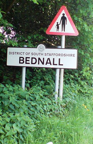
Bednall is a village in Staffordshire, England.

Henhull is a civil parish in the unitary authority of Cheshire East and the ceremonial county of Cheshire, England, which lies to the north west of Nantwich. For administrative purposes, it is combined with adjacent civil parishes of Acton and Edleston to form a total area of 765 hectares. The parish was predominantly rural with scattered farms and houses and no large settlements. In 2019 a 1,100-house development called Kingsbourne was being built in the east of the parish as an extension to the town of Nantwich. Henhull civil parish also includes the hamlets of Basin End, Bluestone, Welshmen's Green and part of Burford. Nearby villages include Acton and Rease Heath.
Uttoxeter Rural is a civil parish in the borough of East Staffordshire, Staffordshire, England, comprising the villages of Stramshall and Bramshall. It is separate from the town of Uttoxeter, and surrounds it to the north, west and south. The population was 1,567 at the 2001 census, increasing to 1,635 at the 2011 Census.

Lapley, Stretton and Wheaton Aston is a civil parish in the South Staffordshire district, in the county of Staffordshire, England. The population of the civil parish at the 2011 census was 2,548.
Teddesley Hall was a large Georgian English country house located close to Penkridge in Staffordshire, now demolished. It was the main seat firstly of the Littleton Baronets and then of the Barons Hatherton. The site today retains considerable traces of the hall, gardens and other buildings, while the former home farm remains a working farm.
Trussell is a surname. Notable people with the surname include:

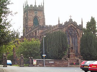
Penkridge is a village and parish in Staffordshire with a history stretching back to the Anglo-Saxon period. A religious as well as a commercial centre, it was originally centred on the Collegiate Church of St. Michael and All Angels, a chapel royal and royal peculiar that maintained its independence until the Reformation. Mentioned in Domesday, Penkridge underwent a period of growth from the 13th century, as the Forest Law was loosened, and evolved into a patchwork of manors of greatly varying size and importance, heavily dependent on agriculture. From the 16th century it was increasingly dominated by a single landed gentry family, the Littletons, who ultimately attained the Peerage of the United Kingdom as the Barons Hatherton, and who helped modernise its agriculture and education system. The Industrial Revolution inaugurated a steady improvement in transport and communications that helped shape the modern village. In the second half of the 20th century, Penkridge grew rapidly, evolving into a mainly residential area, while retaining its commercial centre, its links with the countryside and its fine church.
St John's Church, Stretton is the Church of England parish church of Stretton, South Staffordshire.
There are a number of listed buildings in Staffordshire. The term "listed building", in the United Kingdom, refers to a building or structure designated as being of special architectural, historical, or cultural significance. Details of all the listed buildings are contained in the National Heritage List for England. They are categorised in three grades: Grade I consists of buildings of outstanding architectural or historical interest, Grade II* includes significant buildings of more than local interest and Grade II consists of buildings of special architectural or historical interest. Buildings in England are listed by the Secretary of State for Culture, Media and Sport on recommendations provided by English Heritage, which also determines the grading.
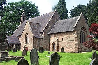
Acton Trussell, Bednall and Teddesley Hay is a civil parish in the district of South Staffordshire, Staffordshire, England. It contains 33 listed buildings that are recorded in the National Heritage List for England. Of these, two are at Grade II*, the middle of the three grades, and the others are at Grade II, the lowest grade. The parish contains the villages of Acton Trussell, Bednall, and Teddesley Hay, and the surrounding countryside. In the parish was Teddesley Hall, a country house, since demolished, and some of the listed buildings are associated with it. The other listed buildings include two churches, memorials in the churchyards, houses and cottages, farmhouses and farm buildings, two road bridges, two bridges over the Staffordshire and Worcestershire Canal which runs through the parish, and a telephone kiosk.
References
- ↑ "Acton Trussell, Bednall & Teddesley Hay". South Staffordshire Council. Archived from the original on 20 March 2015. Retrieved 25 April 2013.
- ↑ "Civil Parish population 2011" . Retrieved 4 December 2015.
| Unitary authorities | |
|---|---|
| Major settlements | |
| Rivers | |
| Canals | |
| Topics | |
| | This Staffordshire location article is a stub. You can help Wikipedia by expanding it. |