Alrewas is a village and civil parish in the Lichfield District of Staffordshire, England.

Edingale is a village and civil parish in Lichfield District, Staffordshire, England. It lies on the River Mease, around 7 miles (11 km) north of Tamworth. Historically, the village is shared with Derbyshire. In 2001 the parish had a population of 598, increasing to 632 at the 2011 census.

Seisdon is a rural village in the parish of Trysull and Seisdon, Staffordshire approximately six miles west of Wolverhampton and the name of one of the five hundreds of Staffordshire. The population recorded at the 2011 census does not distinguish this hamlet from the rest of the parish, which had a population of 1,150.

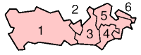
A civil parish is a country subdivision, forming the lowest unit of local government in England. There are 125 civil parishes in the ceremonial county of Bedfordshire, most of the county being parished: Luton is completely unparished; Central Bedfordshire is entirely parished. At the 2001 census, there were 312,301 people living in the 125 parishes, which accounted for 55.2 per cent of the county's population.
A civil parish is a country subdivision, forming the lowest unit of local government in England. There are 104 civil parishes in the ceremonial county of Berkshire, most of the county being parished; Reading is completely unparished; Bracknell Forest, West Berkshire and Wokingham are entirely parished. At the 2001 census, there were 483,882 people living in the 104 parishes, accounting for 60.5 per cent of the county's population.

A civil parish is a country subdivision, forming the lowest unit of local government in England. There are 264 civil parishes in the ceremonial county of Cambridgeshire, most of the county being parished; Cambridge is completely unparished; Fenland, East Cambridgeshire, South Cambridgeshire and Huntingdonshire are entirely parished. At the 2001 census, there were 497,820 people living in the parishes, accounting for 70.2 per cent of the county's population.

Wombourne is a large village and civil parish located in the district of South Staffordshire, in the county of Staffordshire, 4 miles (6 km) south-west of Wolverhampton and just outside the county and conurbation of the West Midlands.

Alstonefield is a village and civil parish in the Peak District National Park and the Staffordshire Moorlands district of Staffordshire, England about 7 miles (11 km) north of Ashbourne, 10 miles (16 km) east of Leek and 16 miles (26 km) south of Buxton. The parish had a population of 274 according to the 2001 census, increasing to 304 at the 2011 census.
Kingswinford Rural District was a rural district in Staffordshire, England from 1894 to 1934. It was created by the Local Government Act 1894, and originally consisted of the two parishes of Amblecote and Kingswinford. Amblecote became a separate urban district in 1898, leaving Kingswinford the only parish in the district.
Seisdon was a rural district in Staffordshire, England from 1894 to 1974. It lay west of Wolverhampton and was formed under the Local Government Act 1894 based on the Seisdon rural sanitary district.

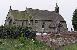
Kelshall is a small village in North East Hertfordshire, England. It is near the town of Royston. It has a village hall and the local church is St Faith's. Kelshall is also the name of the civil parish. Kelshall also has a major road running along one of its boundaries. In the 1880s the church was described as being "ancient, plain, and good, with a tower; and contains a few brasses and monuments".
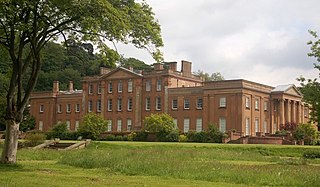
Himley is a small village and civil parish in the English ceremonial county of Staffordshire, situated 4 miles west of Dudley and 5 miles southwest of Wolverhampton. At the time of the 2011 Census, Himley had a population of 802.It is most notable for being the location of Himley Hall, the former home of the Lords of Dudley.

Trysull is a rural village in the county of Staffordshire, England approximately five miles south-west of Wolverhampton. With the adjacent village of Seisdon, it forms the civil parish of Trysull and Seisdon, within the South Staffordshire non-metropolitan district. Until 1974 it formed part of Seisdon Rural District. The 2011 census recorded a usually resident population for the parish of Trysull & Seisdon of 1,150 persons in 455 households.
Chilcote is a village and civil parish in the North West Leicestershire district of Leicestershire, England. Until 1897 it was in Derbyshire. The parish had a population of 108 according to the 2001 census, including Stretton-en-le-Field and increasing to 200 at the 2011 census.

Thorpe Constantine is a small village and civil parish in Staffordshire, England. It lies about 6 miles (10 km) north-east of Tamworth and 6 miles south-west of Measham. The nucleus of the parish is the Thorpe estate.

Wareside is a small village and civil parish in the East Hertfordshire district, in the county of Hertfordshire, England. The population of the civil parish in the 2011 census was 735. It is approximately 3 miles (5 km) away from the town of Ware and the larger town of Hertford, the county town. Nearby villages include Widford, Hunsdon, Babbs Green and Bakers End. Nearby hamlets include Cold Christmas and Helham Green. The B1004 road linking Ware to Bishop's Stortford goes through the village and the main A10 road can be joined up at Thundridge. Fanhams Hall Road links Wareside back to Ware. Ware railway station on the Hertford East Branch Line is located two and a half miles (4 km) away.

Seisdon is a hundred in the county of Staffordshire, England, located in the south-west of that county. It is named after Seisdon, a locality in the parish of Trysull and Seisdon.

Fulford is a village and civil parish about 5 miles (8 km) north east of Stone, in the Stafford district, in the county of Staffordshire, England. The parish includes the settlements of Crossgate, Leadendale, Meir Heath, Mossgate, Rough Close, Saverley Green, Stallington, Townend and part of Blythe Bridge. In 2011 the built-up area had a population of 650 and the parish had 5,931. The village is on one of the tributaries of the River Blythe. The parish is one of the largest in the Stafford district. The parish touches Forsbrook, Hilderstone, Stone Rural, Barlaston and Draycott in the Moors. Fulford is the highest point in the Stafford district and varies between 650 feet (198 m) and 730 feet (223 m) above sea level.
Trysull and Seisdon is a civil parish in the district of South Staffordshire, Staffordshire, England. It contains 22 listed buildings that are recorded in the National Heritage List for England. Of these, one is at Grade II*, the middle of the three grades, and the others are at Grade II, the lowest grade. The parish contains the villages of Trysull and Seisdon and the surrounding countryside. All the listed buildings are in the villages, apart from a lock on the Staffordshire and Worcestershire Canal and a bridge crossing it. Most of the listed buildings are houses, cottages, farmhouses and farm buildings, the earlier of which are timber framed. The other listed buildings include a church, a public house, two road bridges, two mills, and a war memorial.

Rudge is a settlement and civil parish about 6 miles east of Bridgnorth, in the Shropshire district, in the ceremonial county of Shropshire, England. In 2001 the parish had a population of 98. The parish touches those of Claverley and Worfield within Shropshire and Pattingham and Patshull and Trysull and Seisdon in Staffordshire. Rudge shares a parish council with Worfield.
