Related Research Articles
The Admiralty Mountains is a large group of high mountains and individually named ranges and ridges in northeastern Victoria Land, Antarctica. This mountain group is bounded by the sea, and by the Dennistoun Glacier, Ebbe Glacier, and Tucker Glacier.
The Dennistoun Glacier is a glacier, 50 nautical miles long, draining the northern slopes of Mount Black Prince, Mount Royalist and Mount Adam in the Admiralty Mountains of Victoria Land, Antarctica. It flows northwest between the Lyttelton Range and Dunedin Range, turning east on rounding the latter range to enter the sea south of Cape Scott.
The Dominion Range is a broad mountain range, about 30 nautical miles long, forming a prominent salient at the juncture of the Beardmore and Mill glaciers in Antarctica. The range is part of the Queen Maud Mountains The range was discovered by the British Antarctic Expedition, 1907–09 and named by Ernest Shackleton for the Dominion of New Zealand, which generously aided the expedition.

The Ford Ranges are a collection of mountain groups and ranges standing east of Sulzberger Ice Shelf and Block Bay in the northwest part of Marie Byrd Land, Antarctica.
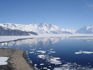
Lennox-King Glacier is a large valley glacier, about 40 nautical miles (70 km) long that flows east into the Ross Ice Shelf.
Alamein Range is a range lying west of Canham Glacier, in the Freyberg Mountains of Antarctica. It was named in association with Lord Bernard Freyberg and the Second New Zealand Expeditionary Force by the Northern Party of New Zealand Geological Survey Antarctic Expedition (NZGSAE), 1963–64.

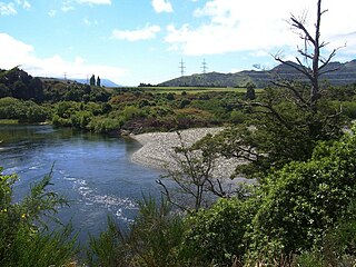
The Mararoa River is one of the braided rivers of the Southland Region of the South Island of New Zealand.
The Doon River is a river in Fiordland, in the Southland Region of New Zealand. It arises near Mount Donald and flows south-east into the south-west arm of Lake Te Anau.
The Elizabeth River, New Zealand is a river of Fiordland, New Zealand. It rises north of Mount George and flows westward through Fiordland National Park into the Malaspina Reach of Doubtful Sound at Olphert Cove. Elizabeth Island is in the Reach by the river mouth. The river and island were named by Captain John Grono after his brig Elizabeth in late 1822 or early 1823.
The Juno River is a river of Fiordland, New Zealand. It rises west of Lake Shirley and flows westward into the Tasman Sea between Taitetimu / Caswell Sound and Taiporoporo / Charles Sound.
The Lyvia River is a river of Fiordland, New Zealand. It rises in the Dingwall Mountains and flows north-eastward into Doubtful Sound at Deep Cove.
The Misty River is a river in Fiordland, New Zealand. It rises to the east of Irene Pass and flows westward into Teardrop Lake and on to Kaikiekie / Bradshaw Sound.
The Monowai River is a river in New Zealand, draining Lake Monowai into the Waiau River and feeding the Monowai Power Station.
The Robertson River is a river in Stewart Island/Rakiura, New Zealand. It rises to the east of the Tin Range and flows into the sea east of Port Pegasus.
The Stillwater River is a river in New Zealand, flowing into Caswell Sound, Fiordland.
The Upukerora River is a river in New Zealand, flowing into Lake Te Anau north of Te Anau township.

The borders of the oceans are the limits of Earth's oceanic waters. The definition and number of oceans can vary depending on the adopted criteria. The principal divisions of the five oceans are the Pacific Ocean, Atlantic Ocean, Indian Ocean, Southern (Antarctic) Ocean, and Arctic Ocean. Smaller regions of the oceans are called seas, gulfs, bays, straits, and other terms. Geologically, an ocean is an area of oceanic crust covered by water.

Sarnoff Mountains is a range of mountains, 251 nautical miles long and 4 to 8 nautical miles wide separating the west-flowing Boyd Glacier and Arthur Glacier in the Ford Ranges of Marie Byrd Land, Antarctica.
The Spey River is a river in the Southland Region of New Zealand. Its entire length lies within the Fiordland National Park. The Spey rises at the Mckenzie Pass and Murrell's Pass either side of Mt Horatio (1,380 metres, and the river flows in a northeasterly direction, emptying into the West Arm of Lake Manapouri adjacent to the intake of the Manapouri Power Station. The Dusky Track follows the Spey valley for much of the river's length.
References
"Place name detail: Rea River". New Zealand Gazetteer. New Zealand Geographic Board . Retrieved 12 July 2009.
45°15′S167°11′E / 45.250°S 167.183°E