List of Sites of Special Scientific Interest in the West Midlands

Last updated

A map of West Midlands, and its location within the United Kingdom also shown West Midlands outline map with UK.png
A map of West Midlands, and its location within the United Kingdom also shown

There are twenty-three Sites of Special Scientific Interest (SSSIs) in the county of the West Midlands, England. As of 2008, of the twenty-three designated sites, eleven have been designated due to their biological interest, nine due to their geological interest and three for both. [1] In England, the body responsible for designating SSSIs is Natural England, which chooses sites because of their flora, fauna, geological or physiographical features. [2] Natural England took over the role of designating and managing SSSIs from English Nature in October 2006 when it was formed from the amalgamation of English Nature, parts of the Countryside Agency and the Rural Development Service. Natural England, like its predecessor, uses the 1974-1996 county system with each area being called an Area of Search. In the West Midlands case, the Area of Search matches the county boundary. [3]

Contents

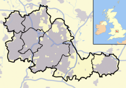
The West Midlands is the second largest conurbation, after Greater London, with a population of over 2.6 million inhabitants. Consisting of three large cities, Wolverhampton, Birmingham and Coventry, the county of the West Midlands is also one of the most densely populated areas in the United Kingdom. The result of this large human population is that every part of the area has been influenced by humansoften negativelyfor example, the clearance of woodland to make room for agriculture. [4] The West Midlands is an area of relatively high ground, ranging from around 500 to 1,000 feet (152–305 m) above sea level, forming the Birmingham Plateau. It is crossed by Britain's main north-south watershed between the basins of the Rivers Severn and Trent. The main habitat types in the area are heathland, woodland and grassland, all of which are found in both urban and rural contexts. [4]

Between the West Midlands conurbation and Coventry is a stretch of green belt land roughly 15 miles (24 km) across known as the "Meriden Gap", which retains a strongly rural character, and is the site of a number of SSSIs including Berkswell Marsh. A smaller green belt is located between Birmingham, Walsall and West Bromwich which includes Sutton Park in Sutton Coldfield. Sutton Park, an SSSI and national nature reserve, has an area of 9.001 square kilometres (3.475 sq mi) [5] making it one of the largest urban parks in Europe and the largest European park outside a capital city. [6] [7]

Sites

Site nameReason for designationArea [A] Grid reference [B] [C] Year in which notified [D] Map [E]
Biological interestGeological interestHectaresAcres
Berkswell Marsh Green check.svg 7.518.5 SP228798 1991 Map
Bickenhill Meadows Green check.svg 7.217.8 SP182822 & SP188816 1991 Map
Brewin's Canal Section  Green check.svg1.343.3 SO936876 1990 Map
Bromsgrove Road Cutting  Green check.svg0.20.5 SO971835 1990 Map
Clayhanger Green check.svg 23.858.8 SK034045 1986 Map
Daw End Railway Cutting Green check.svg8.120.9 SK035002 1986 Map
Doulton's Claypit Green check.svg3.38.2 SO936870 1986 Map
Edgbaston Pool Green check.svg15.638.5 SP054841 1986 Map
Fens Pools Green check.svg37.692.9 SO920886 1989 Map
Hay Head Quarry Green check.svg5.814.3 SP048987 1986 Map
Herald Way Marsh Green check.svgGreen check.svg10.626.2 SP380769 1988 Map
Illey Pastures Green check.svg3.58.6 SO977812 1989 Map
Jockey Fields Green check.svg18.0544.5 SK041030 1994 Map
Ketley Claypit Green check.svg13.733.9 SO898888 1990 Map
Monkspath Meadow Green check.svg1.23.0 SP145763 1986 Map
River Blythe [F] Green check.svgGreen check.svg102.2252.5 SP109729 SP212916 1989 Map
Stubbers Green Bog Green check.svg3.07.4 SK046016 1986 Map
Sutton Park Green check.svg866.12,140.1 SP098974 1987 Map
Swan Pool & The Swag Green check.svg5.714.0 SK040019 1986 Map
Tile Hill Wood Green check.svgGreen check.svg29.472.6 SP279790 1986 Map
Turner's Hill Green check.svg1.53.7 SO909918 1989 Map
Webster's Claypit Green check.svg0.30.8 SP340805 1986 Map
Wren's Nest Green check.svg34.184.3 SO937920 1990 Map

See also

Notes

A Data rounded to one decimal place.
B Grid reference is based on the British national grid reference system, also known as OSGB36, and is the system used by the Ordnance Survey. [8]
C Those SSSIs with more than one OS grid reference are composed of multiple sections, separated by non-SSSI land. [8]
D Site notification consists of designating a site as an SSSI and consulting with the owner(s). This list uses the date notified under Section 28 of the Wildlife and Countryside Act 1981.
E Link to maps using the Nature on the Map service provided by Natural England.
F The River Blythe site extends into the county of Warwickshire and so can be found on the list of SSSIs in Warwickshire. [7]

Related Research Articles

West Midlands (county) County in England

The West Midlands is a metropolitan county and combined authority area in western-central England with a 2020 estimated population of 2,939,927, making it the second most populous county in England after Greater London. It appeared as a metropolitan county in 1974 after the passage of the Local Government Act 1972, to cover parts of Staffordshire, Worcestershire and Warwickshire. The county is a NUTS 2 region within the wider NUTS 1 region of the same name. It embraces seven metropolitan boroughs: the cities of Birmingham, Coventry and Wolverhampton, and the boroughs of Dudley, Sandwell, Solihull and Walsall.

Site of Special Scientific Interest Conservation designation denoting a protected area in the United Kingdom

A Site of Special Scientific Interest (SSSI) in Great Britain or an Area of Special Scientific Interest (ASSI) in the Isle of Man and Northern Ireland is a conservation designation denoting a protected area in the United Kingdom and Isle of Man. SSSI/ASSIs are the basic building block of site-based nature conservation legislation and most other legal nature/geological conservation designations in the United Kingdom are based upon them, including national nature reserves, Ramsar sites, Special Protection Areas, and Special Areas of Conservation. The acronym "SSSI" is often pronounced "triple-S I".

West Midlands conurbation Conurbation in England

The West Midlands conurbation is the large conurbation that includes the cities of Birmingham and Wolverhampton and the towns of Sutton Coldfield, Dudley, Walsall, West Bromwich, Solihull, Stourbridge and Halesowen in the English West Midlands.

Edgbaston Pool

Edgbaston Pool is a Site of Special Scientific Interest located in Edgbaston, Birmingham, England. It is one of 23 SSSI's in the West Midlands. The site has two distinct units (areas) within it. The first is water-related and contains the 7 hectares lake and the input channel of the Chad Brook as well as some land that is either marsh or lake depending on the season. The second, the smaller section is woodland. In total the site measures 15.93 hectares.

References

  1. "SSSIs in the West Midlands". Natural England. Retrieved 2007-12-06.
  2. "Notification of SSSIs". English Nature. Archived from the original on 2012-05-15. Retrieved 2008-02-21.
  3. "County search of SSSIs". Natural England. Archived from the original on 2010-08-19. Retrieved 2007-12-06.
  4. 1 2 "Midlands Plateau Natural Area" (PDF). Natural England. Retrieved 2008-05-26.
  5. "Sutton Park Management Plan" (PDF). Birmingham City Council. 2002. Archived from the original (pdf) on 2007-09-30. Retrieved 2008-02-02.
  6. "Written answer to the House of Commons". from the Head of the Royal Parks Service, 7 February 2002. Retrieved 2008-07-06.
  7. 1 2 Natural England citation sheets for each SSSI. Retrieved on 2007-12-06. (PDF files).
  8. 1 2 "Guide to National Grid". Ordnance Survey. Archived from the original on 2007-10-27. Retrieved 2008-02-21.