
Perthshire, officially the County of Perth, is a historic county and registration county in central Scotland. Geographically it extends from Strathmore in the east, to the Pass of Drumochter in the north, Rannoch Moor and Ben Lui in the west, and Aberfoyle in the south; it borders the counties of Inverness-shire and Aberdeenshire to the north, Angus to the east, Fife, Kinross-shire, Clackmannanshire, Stirlingshire and Dunbartonshire to the south and Argyllshire to the west. It was a local government county from 1890 to 1930.

Rannoch Moor is an expanse of around 50 square miles (130 km2) of boggy moorland to the west of Loch Rannoch in Scotland, where it extends from and into westerly Perth and Kinross, northerly Lochaber, and the area of Highland Scotland toward its south-west, northern Argyll and Bute. Rannoch Moor is designated a Site of Special Scientific Interest (SSSI) and a Special Area of Conservation. Much of the western part of the moor lies within the Ben Nevis and Glen Coe National Scenic Area, one of 40 such areas in Scotland.

Loch Rannoch is a freshwater loch in Perth and Kinross, Scotland. It is over 15 kilometres (9.3 mi) long in a west–east direction with an average width of about 1.2 kilometres (0.75 mi), and is deepest at its eastern end, reaching a depth of 130 metres (440 ft). The River Tummel begins at its eastern end, where the small village of Kinloch Rannoch can be found, whilst the wild expanse of Rannoch Moor extends to the west of the loch. The area surrounding Loch Rannoch, along with Rannoch Moor itself, was formerly part of the native Caledonian Forest that stretched across much of Northern Scotland. Native forest is now largely absent from much of the area, due partly to logging, and partly to the climate becoming wetter, and Loch Rannoch is now largely surrounded by commercial forestry and open hillsides, although a small area remains at the Black Wood of Rannoch on the southern shore of the loch.

Ben Lawers is the highest mountain in the southern part of the Scottish Highlands. It lies to the north of Loch Tay, and is the highest point of a long ridge that includes seven Munros. It is the highest peak in Perthshire, and is the tenth highest Munro in Scotland. Ben Lawers was long thought to be over 4,000 feet (1,219.2 m) in height; accurate measurement in the 1870s showed it to be some 17 feet (5.2 m) short of this figure.

The A830, also known as the Road to the Isles is a major road in Lochaber, Scottish Highlands. It connects the town of Fort William to the port of Mallaig.
The River Tummel is a river in Perth and Kinross, Scotland. Water from the Tummel is used in the Tummel hydro-electric power scheme, operated by SSE.

Loch Tummel is a long, narrow loch, seven kilometres northwest of Pitlochry in the council area of Perth and Kinross, Scotland. It is fed and drained by the River Tummel, which flows into the River Tay about 13 km (8 mi) south-east of the Clunie Dam at the loch's eastern end.

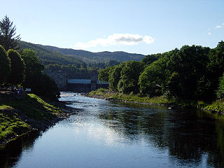
Kinloch Rannoch is a village in Perth and Kinross, Scotland, at the eastern end of Loch Rannoch, 18 miles (29 km) west of Pitlochry, on the banks of the River Tummel. The village is a tourist and outdoor pursuits centre. It has a small population and is fairly remote.

Creise is a Scottish mountain that stands at the eastern end of Glen Coe, just to the south of the A82 road, some 26 kilometres South-southeast of Fort William in the Highland Council area. The mountain was previously known as Clach Leathad in the Munro Tables prior to 1981, its name being changed to Creise when the highest point was found to be 1200 metres further north along the summit ridge when using new mapping techniques.

Càrn Mairg is a Scottish mountain located 18 km west of Aberfeldy in the Perth and Kinross council area. It stands on the northern side of Glen Lyon in a cluster of four Munros known as the Càrn Mairg group which are situated in a semi circle around the Invervar Burn.

Càrn Gorm is a Scottish mountain situated 22 km west of Aberfeldy in the council area of Perth and Kinross, it stands in a group of four Munros known as the Càrn Mairg group or the Glen Lyon Horseshoe on the north side of Glen Lyon.

Beinn a' Chuallaich is a Scottish hill, four kilometres northeast of the village of Kinloch Rannoch in the Perth and Kinross council area. It is part of the high ground between Strath Tummel and Glen Errochty.

Ben Nevis and Glen Coe is a national scenic area (NSA) covering part of the Highlands of Scotland surrounding Ben Nevis and Glen Coe, in which certain forms of development are restricted. It is one of 40 such areas in Scotland, which are defined so as to identify areas of exceptional scenery and to ensure its protection from inappropriate development. The Ben Nevis and Glen Coe NSA covers 903 km2 (349 sq mi) of land, lying within the Highland, Argyll and Bute and Perth and Kinross council areas. A further 19 km2 (7.3 sq mi) of the NSA are marine, covering the sea loch of Loch Leven.
The Loch Rannoch and Glen Lyon National Scenic Area is a national scenic area (NSA) covering the area surrounding Loch Rannoch, Glen Lyon, and the Ben Lawers ranges of mountains in Scotland. It is one of 40 such areas in Scotland, which are defined so as to identify areas of exceptional scenery and to ensure its protection from inappropriate development by restricting certain forms of development. The Loch Rannoch and Glen Lyon NSA covers 48,625 ha, most of which lies in the council area of Perth and Kinross, with a small portion lying in Stirling.