
The National Trust for Scotland for Places of Historic Interest or Natural Beauty, commonly known as the National Trust for Scotland, is a Scottish conservation organisation. It is the largest membership organisation in Scotland and describes itself as "the conservation charity that protects and promotes Scotland's natural and cultural heritage for present and future generations to enjoy".

The River Tay is the longest river in Scotland and the seventh-longest in Great Britain. The Tay originates in western Scotland on the slopes of Ben Lui, then flows easterly across the Highlands, through Loch Dochart, Loch Iubhair and Loch Tay, then continues east through Strathtay, in the centre of Scotland, then southeasterly through Perth, where it becomes tidal, to its mouth at the Firth of Tay, south of Dundee. It is the largest river in the British Isles by measured discharge. Its catchment is approximately 2,000 square miles (5,200 km2), the Tweed's is 1,500 square miles (3,900 km2) and the Spey's is 1,097 square miles (2,840 km2).

Pitlochry is a town in the county of Perthshire in Scotland, lying on the River Tummel. It is administered as part of the council area of Perth and Kinross, and has a population of 2,776, according to the 2011 census.

Loch Rannoch is a freshwater loch in Perth and Kinross, Scotland. It is over 15 kilometres (9.3 mi) long in a west–east direction with an average width of about 1.2 kilometres (0.75 mi), and is deepest at its eastern end, reaching a depth of 130 metres (440 ft). The River Tummel begins at its eastern end, where the small village of Kinloch Rannoch can be found, whilst the wild expanse of Rannoch Moor extends to the west of the loch. The area surrounding Loch Rannoch, along with Rannoch Moor itself, was formerly part of the native Caledonian Forest that stretched across much of Northern Scotland. Native forest is now largely absent from much of the area, due partly to logging, and partly to the climate becoming wetter, and Loch Rannoch is now largely surrounded by commercial forestry and open hillsides, although a small area remains at the Black Wood of Rannoch on the southern shore of the loch.

The Falls of Clyde is the collective name of four linn on the River Clyde near New Lanark, South Lanarkshire, Scotland. The Falls of Clyde comprise the upper falls of Bonnington Linn, Corra Linn, Dundaff Linn, and the lower falls of Stonebyres Linn. Corra Linn is the highest, with a fall of 26 metres (84 ft). Bonnington Linn, Corra Linn and Dundaff Linn are above New Lanark and located within the Falls of Clyde Reserve managed by the Scottish Wildlife Trust, a national nature conservation charity. Stonebyres Linn is located several miles downstream from the reserve and New Lanark.
Rannoch is an area of the Scottish Highlands between the A9 road, to the east, and the A82, to the west. The area is crossed from south to north by the West Highland railway line.

Aberfeldy is a burgh in Perth and Kinross, Scotland, on the River Tay. A small market town, Aberfeldy is located in Highland Perthshire. It was mentioned by Robert Burns in the poem The Birks Of Aberfeldy.
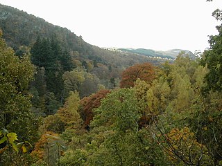
Three miles north of Pitlochry by the A9 road, the Pass of Killiecrankie, is a gorge lying between Ben Vrackie and Tenandry Hill in Perth and Kinross on the River Garry.
The River Tummel is a river in Perth and Kinross, Scotland. Water from the Tummel is used in the Tummel hydro-electric power scheme, operated by SSE.

Loch Tummel is a long, narrow loch, seven kilometres northwest of Pitlochry in the council area of Perth and Kinross, Scotland. It is fed and drained by the River Tummel, which flows into the River Tay about 13 km (8 mi) south-east of the Clunie Dam at the loch's eastern end.
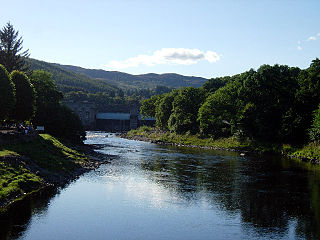
Killiecrankie (; is a village in Perth and Kinross, Scotland on the River Garry. It lies at the Pass of Killiecrankie, by the A9 road which has been bypassed since 1986. The village is home to a power station forming part of the Tummel Hydro-Electric Power Scheme. Much of the riverbank is owned by the National Trust for Scotland. The nearby 10 arch railway viaduct was built in 1863 designed by Joseph Mitchell.
Dunalastair is an estate in the southern part of the Highlands, in Perthshire, Scotland. It is 18 miles west of the town of Pitlochry, lying along the River Tummel between Tummel Bridge to the east and Kinloch Rannoch to the west, and incorporates part of Dunalastair Loch/Reservoir.
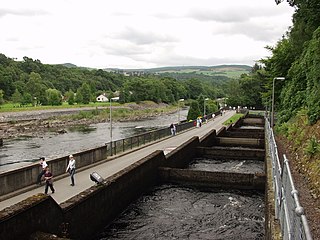
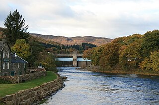
The Pitlochry fish ladder is a fish ladder next to the Pitlochry Power Station, near Pitlochry, Perth and Kinross, Scotland, which allows salmon to travel upstream during the breeding season.

Càrn Mairg is a Scottish mountain located 18 km west of Aberfeldy in the Perth and Kinross council area. It stands on the northern side of Glen Lyon in a cluster of four Munros known as the Càrn Mairg group which are situated in a semi circle around the Invervar Burn.
The Tummel hydro-electric power scheme is an interconnected network of dams, power stations, aqueducts and electric power transmission in the Grampian Mountains of Scotland. Roughly bounded by Dalwhinnie in the north, Rannoch Moor in the west and Pitlochry in the east it comprises a water catchment area of around 1,800 square kilometres (690 sq mi) and primary water storage at Loch Ericht, Loch Errochty, Loch Rannoch and Loch Tummel, in Perth and Kinross. Water, depending on where it originates and the path it takes, may pass through as many as five of the schemes nine power stations as it progresses from north-west to south-east. The scheme was constructed in the 1940s and 50s incorporating some earlier sites. It is currently managed by SSE plc.

Camp Roberts is a California National Guard post in central California, located on both sides of the Salinas River in Monterey and San Luis Obispo counties, now run by the California Army National Guard. It was opened in 1941 and is named after Corporal Harold W. Roberts, a World War I Medal of Honor recipient. Nearby communities include San Miguel, Heritage Ranch, Oak Shores, and Bradley, all unincorporated. The nearest incorporated city is Paso Robles. Camp Roberts is roughly 25 miles southeast of Fort Hunter Liggett.

Threave Garden and Estate is a series of gardens owned and managed by the National Trust for Scotland, located near Castle Douglas in the historical county of Kirkcudbrightshire in Dumfries and Galloway region of Scotland.

The River Garry is a major tributary of the River Tummel, itself a tributary of the River Tay, in the traditional county of Perthshire in the Scottish Highlands. It emerges from the northeastern end of Loch Garry (56.8193°N 4.2311°W), just to the southeast of the Pass of Drumochter, and flows southeastwards and eastwards down Glen Garry to the narrow Pass of Killiecrankie beyond which it joins the Tummel (56.7182°N 3.7790°W).
Dr George Freeland Barbour DPhil, JP, was a Scottish author, philosopher and Liberal Party politician.
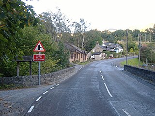
Struan is a small village in Perthshire in Scotland. It is 8 km west of Blair Atholl.
