Firth is a word in the English and Scots languages used to denote various coastal waters in the United Kingdom, predominantly within Scotland. In the Northern Isles, it more usually refers to a smaller inlet. It is linguistically cognate to fjord, which has a more constrained sense in English. Bodies of water named "firths" tend to be more common on the Scottish east coast, or in the southwest of the country, although the Firth of Clyde is an exception to this. The Highland coast contains numerous estuaries, straits, and inlets of a similar kind, but not called "firth" ; instead, these are often called sea lochs. Before about 1850, the spelling "Frith" was more common.
Cromartyshire is a historic county in the Highlands of Scotland, comprising the medieval "old shire" around the county town of Cromarty and 22 enclaves and exclaves transferred from Ross-shire in the late 17th century. The largest part, six times the size of the old shire, is Coigach, northwest from Ullapool. In 1890, Cromartyshire was merged with Ross-shire into the administrative county of Ross and Cromarty. In 1975, the resulting county was combined with Caithness, Inverness-shire, Nairnshire, Sutherland, and parts of Argyllshire and Morayshire to form the Highland council area.

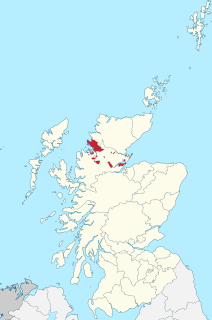
The Cromarty Firth is an arm of the Moray Firth in Scotland.

Ross and Cromarty, sometimes referred to as Ross-shire and Cromartyshire, is a variously defined area in the Highlands and Islands of Scotland. There is a registration county and a lieutenancy area in current use, the latter of which is 8,019 square kilometres in extent. Historically there has also been a constituency of the Parliament of the United Kingdom, a local government county, a district of the Highland local government region and a management area of the Highland Council. The local government county is now divided between two local government areas: the Highland area and Na h-Eileanan Siar. Ross and Cromarty border Sutherland to the north and Inverness-shire to the south.

Ross is a region of Scotland. One of the provinces of Scotland from the 9th century, it gave its name to a later earldom and to the counties of Ross-shire and, later, Ross and Cromarty. The name Ross allegedly derives from a Gaelic word meaning "headland", perhaps a reference to the Black Isle. Another possible origin is the West Norse word for Orkney – Hrossey – meaning horse island; the area once belonged to the Norwegian earldom of Orkney. Ross is a historical comital region, perhaps predating the Mormaerdom of Ross. It is also a region used by the Kirk, with the Presbytery of Ross being part of the Synod of Ross, Sutherland and Caithness.

The Dornoch Firth is a firth on the east coast of Highland, in northern Scotland. It forms part of the boundary between Ross and Cromarty, to the south, and Sutherland, to the north. The firth is designated as a national scenic area, one of 40 such areas in Scotland. The national scenic area covers 15,782 ha in total, of which 4,240 ha is the marine area of the firth below low tide. A review of the national scenic areas by Scottish Natural Heritage in 2010 commented:
By comparison with other east coast firths the Dornoch Firth is narrow and sinuous, yet it exhibits within its compass a surprising variety of landscapes. It is enclosed by abrupt rounded granitic hills clad in heather moor and scree, their Gaelic names of cnoc, meall and creag giving the clue to their character. Their lower slopes are frequently wooded, oakwoods being a noticeable feature of the area, but with other deciduous and coniferous species represented in plantations which vary from the policy plantings of Skibo Castle to the pines of the Struie Forest.

Loch Fleet is a sea loch on the east coast of Scotland, located between Golspie and Dornoch. It forms the estuary of the River Fleet, a small spate river that rises in the hills east of Lairg. The loch was designated a National Nature Reserve (NNR) in 1998, and is managed by a partnership between NatureScot, the Scottish Wildlife Trust (SWT) and Sutherland Estates. The NNR extends to 1058 hectares, including the Loch Fleet tidal basin, sand dunes, shingle ridges and the adjacent pine woods, including Balbair Wood and Ferry Wood. The tidal basin of the loch covers over 630 ha, and forms the largest habitat on the NNR.
The Black Isle is a peninsula within Ross and Cromarty, in the Scottish Highlands. It includes the towns of Cromarty and Fortrose, and the villages of Culbokie, Jemimaville, Rosemarkie, Avoch, Munlochy, Tore, and North Kessock, as well as numerous smaller settlements. About 12,000 people live on the Black Isle, depending on the definition.
Morrich More is an extensive area of dune grassland with wetland communities, on the southern shore of the Dornoch Firth, Scotland.

Ross-shire is a historic county in the Scottish Highlands. The county borders Sutherland to the north and Inverness-shire to the south, as well as having a complex border with Cromartyshire – a county consisting of numerous enclaves or exclaves scattered throughout Ross-shire's territory. Ross-shire includes most of Ross along with Lewis in the Outer Hebrides. Dingwall is the traditional county town. The area of Ross-shire is based on that of the historic province of Ross, but with the exclusion of the many enclaves that form Cromartyshire.

The River Conon is a river in the Highlands of Scotland. It begins at Loch Luichart, and flows in a south-easterly direction to be joined by the River Meig at Scatwell before passing through Loch Achonachie. It is joined by the Black Water at Moy Bridge, and the River Orrin at Urray, before flowing past Conon Bridge and into the Cromarty Firth.

The A832 is a road in the Scottish Highlands, linking Cromarty, on the east coast, to Gairloch on the west coast, and beyond Gairloch to Braemore Junction. It is 126 miles (203 km) long and runs entirely in the former county of Ross and Cromarty. The road forms part of the Wester Ross Coastal Trail.
The River Averon is a river in Easter Ross, north-east Scotland that flows into the Cromarty Firth from the north. It is also known as the River Alness. The river flows for about 15 km eastward and then southward, starting as the main outflow from Loch Morie and passing through the town of Alness around 1.5 km before reaching the sea. Its main tributary is the River Blackwater, one of many rivers of that name, also known as the River Rusdale. The Abhainn na Glass is the main inflow to Loch Morie and may be regarded as part of the River Alness system.