Beauly Firth

Last updated

Beauly Firth
Kessock Bridge (7955403354).jpg
A view of the Kessock Bridge, crossing the Beauly Firth, 2012
Highland UK relief location map.jpg
Red pog.svg
Beauly Firth
Location in the Scottish Highlands
Location Scotland, United Kingdom
Coordinates 57°29′58″N4°13′49″W / 57.49944°N 4.23028°W / 57.49944; -4.23028 Coordinates: 57°29′58″N4°13′49″W / 57.49944°N 4.23028°W / 57.49944; -4.23028
Native nameLinne Fharair  (Scottish Gaelic)
Primary inflows River Beauly
Primary outflows Moray Firth
Max. length6.8 mi (10.9 km)
Max. width2.2 mi (3.5 km)

The Beauly Firth (Scottish Gaelic : Linne Fharair) is a firth in northern Scotland. It is the outlet for both the River Beauly and River Ness. The Beauly Firth is bounded at its western end by the town of Beauly and its eastern by Inverness, where it empties into the Moray Firth.

Several other watercourses drain into the Beauly Firth, including the Moniack and Redcastle Burns, and the Caledonian Canal. At low tide, the firth's north and west shores have extensive mudflats, as well as scattered boulders. [1] The goosander is one of the firth's more common waterfowl. [2]

In 1982, the first bridge crossing the Beauly Firth was opened between North and South Kessock, known as the Kessock Bridge. As part of the A9 road, the bridge linked Inverness to the Black Isle for the first time. Prior to this, the Kessock Ferry crossed the firth at its eastern end since sometime in the 15th century. [3]

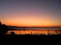
Today, the roads around the Beauly Firth provide a popular circuit for cyclists. However, the A862 (along the firth's southern shore) has grown increasingly busy, making the route difficult at peak times. [4] Although there are no sandy beaches on the firth's coast, its pebbled shores are excellent for stone skipping, and popular amongst artists wanting to depict the sunset.

The Beauly Firth is prone to flooding, affecting shoreline communities such as Bunchrew and Redcastle. This is a particular issue following heavy rainfall, such as in 2020's Storm Ciara. [5]

The Beauly Firth is also known as Poll an Ròid in Scottish Gaelic, meaning "Pool of the Cross". This name is mostly used on Scotland's west coast, and is a reference to a cross erected by the Collegiate Friars of Inverness on an islet in the firth. [6]

History

From studies in nearby Munlochy, scientists predict the Beauly Firth was once the site of a glacier 55m high, its meltwaters flowing into the Munlochy Valley. As the Last Glacial Period ended however, the ice gradually retreated, leaving the firth and its steep surrounding hills. [7]

Several ancient cairns can be found within the Beauly Firth, with at least one reported to contain timber and human remains. [8]

In Ptolemy's geography of the British Isles, written around AD 150 at the height of the Roman Empire, the Beauly Firth is possibly referred to as the "Varar estuary" [9] —a view supported by Scottish scholar William J. Watson. [10]

During the late-19th century, the firth was the cause of much dispute between fishermen there and others on the Moray Firth. According to fisherman in Moray, heavy garvie fishing in the Beauly Firth (where the young fish live in winter months) had led to a decline in their herring stock. This led to calls for the prohibition of garvie fishing in the area. [11]

Footnotes

  1. Bird, Eric (25 February 2010). Encyclopedia of the World's Coastal Landforms. Springer Science & Business Media. ISBN   978-1-4020-8638-0.
  2. Wildfowl. 1981.
  3. "North Kessock and District History". North Kessock & District Local History Society. Retrieved 18 September 2009.
  4. "Around the Beauly Firth, The Highlands – Cycling". www.visitscotland.com. Retrieved 30 July 2020.
  5. Henderson, Michelle. "Highland communities urged to be vigilant as flood warnings are issued". Press and Journal. Retrieved 30 July 2020.
  6. Barron, Hugh (1968). Transactions of the Gaelic Society of Inverness.
  7. Gordon, J. E.; Sutherland, D. G. (6 December 2012). Quaternary of Scotland. Springer Science & Business Media. ISBN   978-94-011-1500-1.
  8. Lewis, Samuel (1851). A Topographical Dictionary of Scotland: Comprising the Several Counties, Islands, Cities, Burgh and Market Towns, Parishes, and Principal Villages, with Historical and Statistical Descriptions: Embellished with Engravings of the Seals and Arms of the Different Burghs and Universities. S. Lewis and Company.
  9. "LacusCurtius • Ptolemy's Geography—Book II, Chapter 2". penelope.uchicago.edu. Retrieved 30 July 2020.
  10. Taylor, Simon (2002). "PLACE-NAME SURVEY OF THE PARISHES OF KILMORACK, KILTARLITY & CONVINTH, AND KIRKHILL, INVERNESS-SHIRE" (PDF).
  11. Buckland, Francis Trevelyan; Walpole, Sir Spencer; Young, Archibald (1878). Report on the Herring Fisheries of Scotland. George E. Eyre and William Spottiswoode.

Related Research Articles

Firth is a word in the English and Scots languages used to denote various coastal waters in the United Kingdom, predominantly within Scotland. In the Northern Isles, it more usually refers to a smaller inlet. It is linguistically cognate to fjord which has a more constrained sense in English. Bodies of water named "firths" tend to be more common on the Scottish east coast, or in the southwest of the country, although the Firth of Clyde is an exception to this. The Highland coast contains numerous estuaries, straits, and inlets of a similar kind, but not called "firth" ; instead, these are often called sea lochs. Before about 1850, the spelling "Frith" was more common.

Inverness City in the Scottish Highlands

Inverness is a city in the Scottish Highlands. It is the administrative centre for The Highland Council and is regarded as the capital of the Highlands. Historically it served as the county town of the county of Inverness-shire. Inverness lies near two important battle sites: the 11th-century battle of Blàr nam Fèinne against Norway which took place on the Aird, and the 18th century Battle of Culloden which took place on Culloden Moor. It is the northernmost city in the United Kingdom and lies within the Great Glen at its northeastern extremity where the River Ness enters the Beauly Firth. At the latest, a settlement was established by the 6th century with the first royal charter being granted by Dabíd mac Maíl Choluim in the 12th century. Inverness and Inverness-shire are closely linked to various influential clans, including Clan Mackintosh, Clan Fraser and Clan MacKenzie.

River Ness River in the United Kingdom

The River Ness is a river about 6 miles long, which flows from the northern end of Loch Ness in Scotland, through Loch Dochfour, north-east to Inverness, with a total fall in height of about 16 metres before discharging into the Beauly Firth. The river is the origin of the name of Inverness which is from Scottish Gaelic: Inbhir Nis, meaning "Mouth of the Ness".

Moray Firth

The Moray Firth is a roughly triangular inlet of the North Sea, north and east of Inverness, which is in the Highland council area of north of Scotland. It is the largest firth in Scotland, stretching from Duncansby Head in the north, in the Highland council area, and Fraserburgh in the east, in the Aberdeenshire council area, to Inverness and the Beauly Firth in the west. Therefore, three council areas have Moray Firth coastline: Highland to the west and north of the Moray Firth and Highland, Moray and Aberdeenshire to the south. The firth has more than 800 kilometres of coastline, much of which is cliff.

A9 road (Scotland) Major road in Scotland

The A9 is a major road in Scotland running from the Falkirk council area in central Scotland to Scrabster Harbour, Thurso in the far north, via Stirling, Bridge of Allan, Perth and Inverness. At 273 miles (439 km), it is the longest road in Scotland and the fifth-longest A-road in the United Kingdom. Historically it was the main road between Edinburgh and John o' Groats, and has been called the spine of Scotland. It is one of the three major north–south trunk routes linking the Central Belt to the Highlands - the others being the A82 and the A90.

Ross and Cromarty Area in the Highlands and Islands of Scotland

Ross and Cromarty, sometimes referred to as Ross-shire and Cromartyshire, is a variously defined area in the Highlands and Islands of Scotland. There is a registration county and a lieutenancy area in current use, the latter of which is 8,019 square kilometres in extent. Historically there has also been a constituency of the Parliament of the United Kingdom, a local government county, a district of the Highland local government region and a management area of the Highland Council. The local government county is now divided between two local government areas: the Highland area and Na h-Eileanan Siar. Ross and Cromarty border Sutherland to the north and Inverness-shire to the south.

Ross, Scotland

Ross is a region of Scotland. One of the provinces of Scotland from the 9th century, it gave its name to a later earldom and to the counties of Ross-shire and, later, Ross and Cromarty. The name Ross allegedly derives from a Gaelic word meaning "headland", perhaps a reference to the Black Isle. Another possible origin is the West Norse word for Orkney – Hrossey – meaning horse island; the area once belonged to the Norwegian earldom of Orkney. Ross is a historical comital region, perhaps predating the Mormaerdom of Ross. It is also a region used by the Church, with the Presbytery of Ross being part of the Synod of Ross, Sutherland and Caithness.

Great Glen Scottish valley along geological fault line

The Great Glen, also known as Glen Albyn or Glen More, is a glen in Scotland running for 62 miles (100 km) from Inverness on the edge of Moray Firth, in an approximately straight line to Fort William at the head of Loch Linnhe. It follows a geological fault known as the Great Glen Fault, and bisects the Scottish Highlands into the Grampian Mountains to the southeast and the Northwest Highlands to the northwest.

Kessock Bridge Cable-stayed bridge in Scotland

The Kessock Bridge carries the A9 trunk road across the Beauly Firth at Inverness, Scotland.

Findhorn is a village in Moray, Scotland. It is located on the eastern shore of Findhorn Bay and immediately south of the Moray Firth. Findhorn is 3 miles (5 km) northwest of Kinloss, and about 5 miles (9 km) by road from Forres.

Black Isle Peninsula in Scotland

The Black Isle is a peninsula within Ross and Cromarty, in the Scottish Highlands. It includes the towns of Cromarty and Fortrose, and the villages of Culbokie, Jemimaville, Rosemarkie, Avoch, Munlochy, Tore, and North Kessock,as well as numerous smaller settlements. About 12,000 people live on the Black Isle, depending on the definition.

Merkinch Neighbourhood in Scotland

Merkinch is an area of the city of Inverness in the Highland council area of Scotland. One of the oldest neighbourhoods in Inverness, it's situated in the city's north-west flanked by the Caledonian Canal to its west and River Ness to its east. It is a traditionally working-class area.

River Beauly

The River Beauly is a river in the Scottish Highlands, about 15 km west of the city of Inverness.

North Kessock Human settlement in Scotland

North Kessock is a village on the Black Isle north of Inverness.

Longman, Inverness

The Longman is an area in the city of Inverness, Scotland. Located north of the city centre, it is bounded by the Moray Firth and River Ness and is home to the largest industrial estate in the city.

The Aird

The Aird is an area of the County of Inverness, to the west of the City of Inverness. It is situated to the south of the River Beauly and the Beauly Firth, and to the north of Glenurquhart and the northern end of Loch Ness.

A835 road

The A835 is a road in the Scottish Highlands linking Inverness to Ullapool and the Far North of Scotland.

The Fortrose Branch, also known as the Black Isle Railway, was a railway branch line serving Fortrose in the Black Isle, in the north of Scotland. It was built by the Highland Railway as a tactical measure to exclude a rival railway company and to move the locals from Fortrose onwards to other destinations.

Kessock Ferry

The Kessock Ferry used to ply between Inverness and the Black Isle, across the Beauly Firth. It was withdrawn on the opening of the Kessock Bridge in 1982.

Charlestown, Black Isle Human settlement in Scotland

Charleston is a village on the north shore of the Beauly Firth, about 1 mile west of the Kessock Bridge, in east Ross-shire, Scottish Highlands, within the Scottish council area of Highland. An artificially created village, it was laid out in 1812 by Sir Charles Mackenzie of Kilcoy.