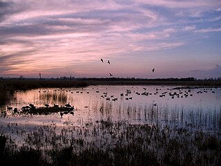
Strumpshaw Fen is a nature reserve managed by the Royal Society for the Protection of Birds (RSPB). It is situated at Strumpshaw on the River Yare in the English county of Norfolk around 6 miles (9.7 km) east of Norwich. The Buckenham Marshes RSPB reserve borders the reserve to the east.
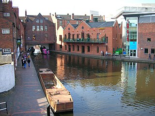
Birmingham Canal Navigations (BCN) is a network of canals connecting Birmingham, Wolverhampton, and the eastern part of the Black Country. The BCN is connected to the rest of the English canal system at several junctions. It was owned and operated by the Birmingham Canal Navigations Company from 1767 to 1948.

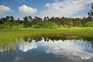
The Cotswold Water Park is the United Kingdom's largest marl lake system, straddling the Wiltshire–Gloucestershire border, north-west of Cricklade and south of Cirencester. There are 180 lakes, spread over 42 square miles (110 km2).

Coombe Hill Canal lies in the Vale of Gloucester, south west England, north of Leigh and runs west 2.75 miles (4.43 km) from Coombe Hill Basin to the River Severn near Wainlode Hill. It opened in 1796 and closed 80 years later in 1876, after the only lock was damaged by flooding. The Gloucestershire Wildlife Trust purchased the Coombe Hill Canal nature reserve in 1985 and the area is managed by the trust. Adjacent to the Coombe Hill Canal is a large area of wet meadowland situated midway between Gloucester and Tewkesbury to the west of the A38, which was purchased by the trust in 1999. There is a north and a south meadow. This land and the Canal itself often flood in winter, which attracts hundreds of wildfowl.

The Stourbridge Canal is a canal in the West Midlands of England. It links the Staffordshire and Worcestershire Canal with the Dudley Canal, and hence, via the Birmingham Canal Navigations, to Birmingham and the Black Country.

The Dudley Canal is a canal passing through Dudley in the West Midlands of England. The canal is part of the English and Welsh network of connected navigable inland waterways and forms part of the popular Stourport Ring narrowboat cruising route.
Priddy Pools is a 52.7-hectare (130-acre) geological Site of Special Scientific Interest at Priddy in the Mendip Hills, Somerset, notified in 1972.

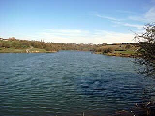
Brandon Marsh is a Site of Special Scientific Interest (SSSI) and nature reserve in Warwickshire, England. It is situated adjacent to the River Avon, near the village of Brandon, a few miles east of Coventry.

The Titford Canal is a narrow (7 foot) canal, a short branch of the Birmingham Canal Navigations (BCN) in Oldbury, West Midlands, England.

Ashleworth Ham is a 104.73-hectare (258.8-acre) biological Site of Special Scientific Interest. It is a large area of grassland on the Severn floodplain, north of Ashleworth in Gloucestershire, England. It is registered as a Site of Special Scientific Interest and was notified in 1974 and renotified in 1985. Ashleworth Ham received this designation because it is one of three sites in the Severn Vale where migratory waterfowl winter.

Delph Locks or the Delph Nine are a series of eight narrow canal locks on the Dudley No. 1 Canal in Brierley Hill, in the West Midlands, England. They were opened in 1779, and reopened in 1967 following restoration of the Dudley Canal and the Stourbridge Canal in a joint venture between the Staffordshire and Worcestershire Canal Society and the British Waterways Board.

The Stourbridge Extension Canal was a short canal built to serve a number of mines in the Kingswinford area of Staffordshire in England. Although connected to the Stourbridge Canal, it was independent from it. It opened in 1840, and was abandoned in 1935. A short section of it is still used as moorings for boats using the Stourbridge Canal.

Ingrebourne Marshes are a 74.8 hectare biological Site of Special Scientific Interest in Hornchurch in the London Borough of Havering. Ingrebourne Valley Local Nature Reserve includes a small part of the SSSI west of the River Ingrebourne. The site is managed by the Essex Wildlife Trust

Castor Hanglands is an 89.8-hectare (222-acre) biological Site of Special Scientific Interest west of Peterborough in Cambridgeshire. The site is also a National Nature Reserve, and it is a Nature Conservation Review site, Grade I for its woodlands and Grade 2 for its grassland. It is common land managed by Natural England.

Offham Marshes, also known as The Pells and Offham Marsh, is a 39.1-hectare (97-acre) biological Site of Special Scientific Interest on the northern outskirts of Lewes in East Sussex in parish of Hamsey. It includes the Pellbrook Cut, an area to the north of it called The Pells and the marshland to the south of the Cut and east of the railway track.

Tring Reservoirs is a group of four reservoirs close to Tring on the border of Hertfordshire and Buckinghamshire, England. Their purpose is to feed the Grand Union Canal.

Bourgoyen-Ossemeersen is a nature reserve on the outskirts of the Belgian city of Ghent. It lies mainly in the district of Mariakerke and covers 230 hectares. It mostly consists of wet, often flooded, meadows interspersed with ditches and canals, and is an important wintering area for water birds. It acts as a buffer zone between the city and the R4 ring road's noise-reducing barriers have been erected to lessen the road's impact on the wildlife.

Warren's Hall Country Park is a local nature reserve situated in Sandwell Metropolitan Borough in the West Midlands of England. It lies next to Bumble Hole Local Nature Reserve. It includes ponds, canals, grassland, small wooded areas and the entrance to Netherton Canal Tunnel.
Buckpool and Fens Pool Local Nature Reserve is situated in the Pensnett area of the West Midlands. The largest area of open water in Dudley Metropolitan Borough, it contains both large and small ponds, one end of the Stourbridge Canal, streams and grassy areas. It was created in 1993.

Lavells Lake is a 12.5-hectare (31-acre) Local Nature Reserve on the outskirts of Woodley, a suburb of Reading in Berkshire. It is owned by Wokingham District Council and managed by the council and The Friends of Lavell's Lake. The nature reserve is part of Dinton Pastures Country Park.
