The Upper Goyt Valley is the southern section of the valley of the River Goyt in North West England.

The River Cole is a 25 miles (40 km) river in the English Midlands. It rises on the lower slopes of Forhill, one of the south-western ramparts of the Birmingham Plateau, at Red Hill and flows south before flowing largely north-east across the plateau to enter the River Blythe below Coleshill, near Ladywalk, shortly before the Blythe meets the Tame. This then joins the Trent, whose waters reach the North Sea via the Humber Estuary. Its source is very near the main watershed of Midland England : tributaries are few and very short except in the lower reaches, so the Cole is only a small stream.

Hampton in Arden is a village and civil parish located in the Forest of Arden in the Metropolitan Borough of Solihull, in the West Midlands of England. Hampton in Arden was part of Warwickshire until the 1974 boundary changes. It lies within the Meriden Gap area of countryside between Solihull and Coventry. Hampton in Arden is a typical Arden village, but is now very much an affluent commuter settlement for nearby Birmingham, Solihull and Coventry. In 1968 the central part of the village was designated a Conservation Area, which is an "area of special architectural or historic interest, the character or appearance of which it is desirable to preserve or enhance". Its population in the 2001 census was 1,787, increasing to 1,834 at the 2011 Census.

The Metropolitan Borough of Solihull is a metropolitan borough in West Midlands county, England. It is named after its largest town, Solihull, from which Solihull Metropolitan Borough Council is based. For Eurostat purposes it is a NUTS 3 region and is one of seven boroughs or unitary districts that comprise the "West Midlands" NUTS 2 region. Much of the large residential population in the north of the borough centres on the communities of Castle Bromwich, Fordbridge, Kingshurst, Marston Green and Smith's Wood as well as the town of Chelmsley Wood. In the south are the towns of Solihull and Shirley, and the large villages of Knowle, Dorridge, Meriden and Balsall Common.

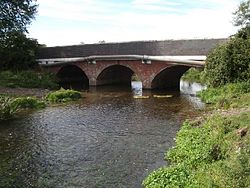
A packhorse bridge is a bridge intended to carry packhorses across a river or stream. Typically a packhorse bridge consists of one or more narrow masonry arches, and has low parapets so as not to interfere with the panniers borne by the horses. Multi-arched examples sometimes have triangular cutwaters that are extended upward to form pedestrian refuges.
Kingsbury is a large village and civil parish in the North Warwickshire district of the county of Warwickshire, in the West Midlands region of England. The civil parish population at the 2011 census was 7,652.

Barston is a village and civil parish in Metropolitan Borough of Solihull in the West Midlands of England. It is approximately 4 miles (6.5 km) east of Solihull and is located inside a large meander of the River Blythe, at the western edge of the Meriden Gap, and midway between the far larger villages of Balsall Common and Hampton-in-Arden. The nearest large city is Birmingham, 11 miles (18 km) away to the west. According to the 2001 UK Census, the parish had a population of 499, increasing to 533 at the 2011 Census.

Ashford-in-the-Water is a village and civil parish in the Derbyshire Peak District, England. The village is on the River Wye, 2 miles (3 km) north-west of Bakewell. It is known for the quarrying of Ashford Black Marble, and for the maidens' garlands made to mark the deaths of virgins in the village until 1801. Some of these are preserved in the parish church. The civil parish population taken at the 2011 Census was 559.

Nether Whitacre is a small village and larger rural civil parish in North Warwickshire, Warwickshire, England.

Essex Bridge is a Grade I listed packhorse bridge over the River Trent near Great Haywood, Staffordshire, England.

The River Sowe is a river in Warwickshire and West Midlands, England. It is a tributary of the River Avon, and flows into it just south of Stoneleigh about 5 miles (8 km) south of Coventry. It is about 12 miles (19 km) long.
Solihull is a market town and the administrative centre of the wider Metropolitan Borough of Solihull in West Midlands County, England. The town had a population of 126,577 at the 2021 Census. Solihull is situated on the River Blythe in the Forest of Arden area. Solihull's wider borough had a population of 216,240 at the 2021 Census.
The River Doe Lea is a river which flows near Glapwell and Doe Lea in Derbyshire, England. The river eventually joins the River Rother near Renishaw. The river contained 1,000 times the safe level of dioxins in 1991, according to a statement made by Dennis Skinner, (MP) in the House of Commons in 1992. The river flows through the site of the former Coalite plant near Bolsover, where coke, tar and industrial chemicals were manufactured until the plant closed in 2004.

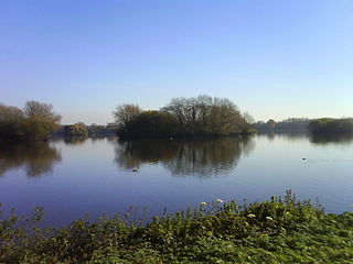
Malvern and Brueton Park is a town park and local nature reserve in Solihull in the West Midlands. The park is formed from a comparatively narrow strip of land, with the length being approximately ten times the average width, but it is looped forming a roughly U-shaped layout. The parks cover an area of approximately 130 acres (53 ha). Historically the park was formed by the joining of two separate parcels of different land. There is a large water feature, Brueton Park Lake, which runs through the southern end of the park, and is formed by the damming of a local watercourse, the River Blythe.
Trawden Forest is a civil parish in Pendle, Lancashire, England. It contains 39 listed buildings that are recorded in the National Heritage List for England. Of these, six are at Grade II*, the middle grade, and the others are at Grade II, the lowest grade. The parish contains the village of Trawden and the hamlets of Cottontree, Winewall, and Wycoller, and is otherwise completely rural. Most of the listed buildings are houses and associated structures, farmhouses and farm buildings. Six bridges are listed, two clapper bridges, a packhorse bridge, two medieval or post-medieval bridges, and a 19th-century road bridge. The other listed buildings include a group of medieval stones, the ruins of a former large house, and a public house.

Winster is a village in the South Lakeland District of Cumbria, in North West England. Historically within the county of Westmorland, it is situated less than two miles east of Windermere, England's largest natural lake. The village is within the Lake District National Park. The village has a pub, the Brown Horse Inn, an 1850s coaching inn.

Oldcotes Dyke is the name of the final section of a river system that drains parts of north Nottinghamshire and the Metropolitan Borough of Rotherham in South Yorkshire, England. Historically, it has supported milling, with seven water mills drawing their power from its water, and ran through the grounds of the Cistercian Roche Abbey. It is a tributary of the River Ryton.

Jacob's Ladder is a bridleway between Kinder Scout plateau and the hamlet of Upper Booth in the Vale of Edale, in the Derbyshire Peak District of England.
Youlgreave is a civil parish in the Derbyshire Dales district of Derbyshire, England. The parish contains 57 listed buildings that are recorded in the National Heritage List for England. Of these, one is listed at Grade I, the highest of the three grades, one is at Grade II*, the middle grade, and the others are at Grade II, the lowest grade. The parish contains the village of Youlgreave, the hamlet of Alport and the surrounding countryside. Most of the listed buildings are houses, cottages and associated structures, farmhouses and farm buildings. The other listed buildings include a church and associated structures, a public house, bridges, a milestone, a conduit head, a school, a youth hostel and a telephone kiosk.

Hampton in Arden packhorse bridge crosses the River Blythe near Hampton in Arden in the West Midlands of England, between Birmingham and Coventry. Dating from the 15th century, it is the only bridge of its kind in the area now covered by the West Midlands, and is a grade II* listed building and a scheduled monument.