Moseley and Kings Heath is a ward within the constituency of Hall Green, covering the greater part of the Moseley and Kings Heath areas of Birmingham, England.

Icknield Street or Ryknild Street is a Roman road in England, with a route roughly south-west to north-east. It runs from the Fosse Way at Bourton on the Water in Gloucestershire to Templeborough in South Yorkshire. It passes through Alcester, Studley, Redditch, Metchley Fort, Birmingham, Sutton Coldfield, Lichfield, Burton upon Trent and Derby.

Sutton Coldfield or the Royal Town of Sutton Coldfield, known locally as Sutton ( ), is a town and civil parish in the City of Birmingham, West Midlands, England. The town lies around 8 miles northeast of Birmingham city centre, 9 miles south of Lichfield, 7 miles southwest of Tamworth and 7 miles east of Walsall.

The River Rea is a small river which passes through Birmingham, England. It is the river on which Birmingham was founded by the Beorma tribe in the 7th century.

Northfield is a residential area in outer south Birmingham, England, and near the boundary with Worcestershire, which it was historically within. It is also a council constituency, managed by its own district committee. The constituency includes the wards of Kings Norton, Longbridge, Weoley Castle and the smaller ward of Northfield that includes West Heath and Turves Green.

Kings Norton, alternatively King's Norton, is an area of Birmingham, England. Historically in Worcestershire, it was also a Birmingham City Council ward within the Government of Birmingham, England. The district lies 6.5 miles south-southwest of Birmingham city centre and is within 1.5 miles of the north Worcestershire border. Kings Norton has been split into two wards, Kings Norton North and Kings Norton South.

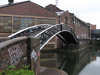
Selly Oak is an industrial and residential area in south-west Birmingham, England. The area gives its name to Selly Oak ward and includes the neighbourhoods of: Bournbrook, Selly Park, and Ten Acres. The adjoining wards of Edgbaston and Harborne are to the north of the Bourn Brook, which was the former county boundary, and to the south are Weoley, and Bournville. A district committee serves the four wards of Selly Oak, Billesley, Bournville and Brandwood. The same wards form the Birmingham Selly Oak constituency, represented since 2010 by Steve McCabe (Labour). Selly Oak is connected to Birmingham by the Pershore Road (A441) and the Bristol Road (A38). The Worcester and Birmingham Canal and the Birmingham Cross-City Railway Line run across the Local District Centre.

Stirchley is a suburb in south-west Birmingham, England.
Bordesley is an area of Birmingham, England, 1.2 miles (2 km) south east of the city centre straddling the Watery Lane Middleway ring road. It should not be confused with nearby Bordesley Green. Commercial premises dominate to the west of the ring road, but much of this area is to be redeveloped. Blocks of residential apartments are planned and set for completion from the mid-2020s onwards. The largely residential area east of the ring road was renamed Bordesley Village following large scale clearance of back-to-back houses and redevelopment in the 1980s and 90s. Bordesley is the real life setting of the BBC series Peaky Blinders, and home to Birmingham City Football Club's ground, St Andrew's.
Smithfield was an inner-city area of Birmingham, England, southeast of the Bull Ring markets.
Selly Park is a residential suburban district in south-west Birmingham, England. The suburb of Selly Park is located between the Bristol Road (A38) and the Pershore Road (A441).

Pineapple Road railway station is a railway station under construction in Stirchley, Birmingham. It was first opened in 1903 and closed in 1941.
Ashted is an area of Birmingham in the United Kingdom, within the ward of Nechells. The area is located approximately 0.75 miles (1.21 km) north-east of Birmingham City Centre near to the city's Eastside district, and forms the western extremity of Duddeston. It is within the boundaries of Nechells Green, and provides mainly estate and high-rise residences.

Bromford, referred to locally as "the Bromford", is an industrial and residential area of Birmingham, situated between Ward End, Alum Rock, Hodge Hill, Washwood Heath, Shard End, Stechford, Castle Bromwich and Tyburn. The industrial area is predominantly situated on the north side of the M6 motorway, including The Bromford Gate industrial park, Fort Shopping Park, and Fort Dunlop, with one industrial site sitting east of the M6 called Bromford Central. The residential area sits adjacent to the East of the M6 comprising two neighbourhoods, Bromford built along Bromford Drive, and The Firs built along Chipperfield Road. The industrial and residential areas have increasingly become two separate distinguishable places, and not recognised locally as joined or one. This is signified by the M6 & River Tame dividing the two areas, poor public transport links between the two areas, and the areas sitting within three different local authority wards, and two parliamentary constituencies (industrial area situated within Birmingham Erdington and residential area situated within Birmingham Hodge Hill.
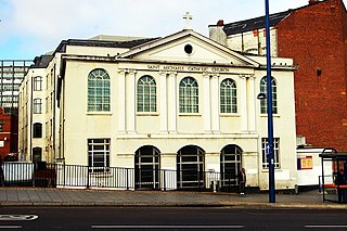
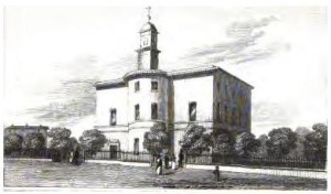
St Michael's Catholic Church is a Catholic church located on Moor Street in Birmingham, England. It received Grade II listed building status on 25 April 1952.
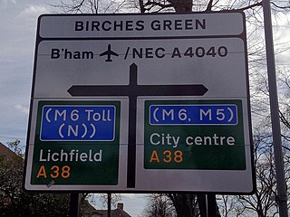
Birches Green is a small area of Tyburn in Birmingham, England, within the parliamentary constitiuency of Erdington. It is located between Gravelly Hill, Erdington and the M6 motorway.

Bordesley Hall was an 18th century manor house near Bordesley, Birmingham, which stood in a 15 hectare park south of the Coventry Road in an area between what is now Small Heath and Sparkbrook. The Georgian house was the successor to an earlier medieval moated manor.
The Church of the Ascension, Stirchley (1901–1965) was a Church of England parish church in Stirchley, Birmingham.

The Chad Brook is a stream, or brook, wholly within Birmingham, England. It rises in the district of Harborne, giving its name to the area known as Chad Valley, and runs through the suburb of Edgbaston.


