Joseph Gillott was an English pen-manufacturer and patron of the arts based in Birmingham.
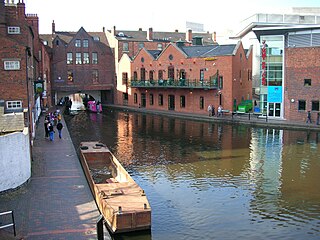
Birmingham Canal Navigations (BCN) is a network of canals connecting Birmingham, Wolverhampton, and the eastern part of the Black Country. The BCN is connected to the rest of the English canal system at several junctions.

Edgbaston is an affluent suburban area of central Birmingham, England, historically in Warwickshire, and curved around the southwest of the city centre. It is bordered by Moseley to the south east and by Smethwick and Winson Green to the north west.

Harborne is an area of south-west Birmingham, England, three miles (5 km) southwest from Birmingham city centre. It is a Birmingham City Council ward in the formal district and in the parliamentary constituency of Birmingham Edgbaston.

Ashford is a town in the Borough of Spelthorne, approximately 13.5 mi (22 km) west of central London. Its name derives from a crossing point of the River Ash, a distributary of the River Colne. Historically part of Middlesex, the town's wards have been part of Surrey since 1965. Ashford consists of relatively low density low- and medium-rise buildings, none of them being high rise. If excluding apartments most houses are semi-detached.
Four Oaks is an extremely affluent residential area in Sutton Coldfield, West Midlands, lying along the north and east borders of Sutton Park. Four Oaks is situated approximately 7 1⁄2 miles (12.1 km) north of Birmingham City Centre, and is bordered by Sutton Park, Streetly, Mere Green, Little Aston and Roughley. Four Oaks has a population of 21,690 as of 2004, and is part of the Sutton Four Oaks electoral ward.
Stirchley is in the south west of Birmingham, England.

West Heath is a residential area of Birmingham, England on the boundary with Worcestershire. Forming the larger part of the ward of Longbridge And West Heath it is situated between Kings Norton, Northfield, Longbridge and Cofton Hackett and lies on traditional heathland formed in the 13th century as part of the Kings Norton manorial lands, and was historically in Worcestershire.
Birmingham, Ladywood is a constituency of part of the city of Birmingham, represented in the House of Commons since 2010 by Shabana Mahmood of the Labour Party.

Edgbaston Reservoir, originally known as Rotton Park Reservoir and referred to in some early maps as Rock Pool Reservoir, is a canal feeder reservoir in Birmingham, England.. It is situated close to Birmingham City Centre and is a Site of Importance for Nature Conservation.

Bournbrook is an industrial and residential district in southwest Birmingham, England, in both the Selly Oak Council Ward and the Parliamentary District of Selly Oak. Prior to what is commonly termed the Greater Birmingham Act, which came into effect on 9 November 1911, the Bourn Brook watercourse was the North Eastern boundary of Worcestershire, and the area was locally governed by the King’s Norton and Northfield Urban District Council.

The Church of St Augustine of Hippo in Lyttelton Road, Edgbaston, Birmingham, England, is a parish church in the Church of England.
Birmingham All Saints was a parliamentary constituency in the city of Birmingham, which returned one Member of Parliament (MP) to the House of Commons of the Parliament of the United Kingdom. Elections were held using the first-past-the-post voting system.
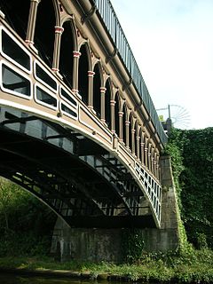
The Engine Arm or Birmingham Feeder Arm near Smethwick, West Midlands, England, is a short canal built by Thomas Telford in 1825 to carry water from Rotton Park Reservoir to the Old Main Line of the BCN Main Line Canal.
The Harborne Railway was a short standard gauge railway line constructed for residential travel from the Harborne area into the centre of Birmingham, England. The line opened in 1874, and was worked by the London and North Western Railway. As business developed, an increasingly frequent passenger service was operated, at its peak thirty trains each way daily.
The BCN Main Line, or Birmingham Canal Navigations Main Line describes the evolving route of the Birmingham Canal between Birmingham and Wolverhampton in England.
This article is intended to show a timeline of events in the History of Birmingham, England, with a particular focus on the events, people or places that are covered in Wikipedia articles.

Rotton Park Road railway station was a railway station in England, built by the Harborne Railway and operated by the London and North Western Railway in 1874.

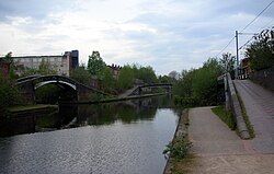
The Icknield Port Loop is a 0.6-mile (1 km) loop of the eighteenth-century-built Old BCN Main Line canal in Birmingham, England, about 2 miles (3 km) west of the city centre, which opened to traffic on 6 November 1769 and in some definitions includes its straighter bypass built in September 1827, a 550-yard (500 m) section of the New BCN Main Line. Most of the 56 acres (23 ha) of land thereby enclosed is derelict meaning the canal serves the Canal & River Trust maintenance depot at Icknield Port and conveys water from Edgbaston Reservoir to the BCN Main Line. The enclosed land has no pedestrian or vehicular access. Icknield Port (Loop) takes its name from the Roman Icknield Street which passed nearby, the exact route of which is unknown.

Summerfield is a district in Birmingham, in the West Midlands county of England. The area takes its name from Summerfield House, owned by members of the Chance family, local industrialists, and which stood on the site of the current bandstand in Summerfield Park.