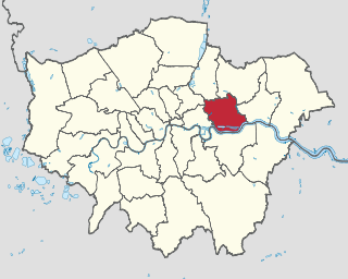
Birmingham is the second-most populous city in the United Kingdom, after London, and the most populous city in the English Midlands. With an estimated population of 1,137,100 as of 2017, Birmingham is the cultural, social, financial and commercial centre of the Midlands. It is the main centre of the West Midlands conurbation, which is the third most populated urban area in the United Kingdom, with a population in 2011 of 2,440,986. The wider Birmingham metropolitan area is the second largest in the United Kingdom with a population of over 3.7 million. Birmingham is frequently referred to as the United Kingdom's "second city".
Weoley Castle is a residential suburban district in south-west Birmingham, England. The area is part of the Weoley local authority electoral ward, and also comes under the Northfield local council constituency. The suburb of Weoley Castle is bordered by Selly Oak to the east, Harborne to the north, Bartley Green to the west, and Weoley Hill and Shenley Fields to the south.
Shenley Green was a post war development built on the location of Shendley Green Farm and by 1958 there were around 8,000 residents.
Bournville Village Trust is an organisation that was created to maintain and improve the suburb of Bournville, located in Birmingham. However, during the 20th century it expanded its geographical coverage to include developments in Shenley Green, Lightmoor in Telford, Bloomsbury in Nechells and Rowheath.
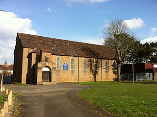
The Shenley Green Centre was conceived by local people and built in 1965 as a youth club. St. David's Church was opened in 1970 and its prominent feature is the large lantern tower. The former church building became the community hall for the new church.
A geographic coordinate system is a coordinate system that enables every location on Earth to be specified by a set of numbers, letters or symbols. The coordinates are often chosen such that one of the numbers represents a vertical position and two or three of the numbers represent a horizontal position; alternatively, a geographic position may be expressed in a combined three-dimensional Cartesian vector. A common choice of coordinates is latitude, longitude and elevation. To specify a location on a plane requires a map projection.
At the Shenley Green Centre there is also a range of useful shops which includes a supermarket, butchers and a chemist which serve the local residents who reside there
This page is based on this Wikipedia article Text is available under the CC BY-SA 4.0 license; additional terms may apply. Images, videos and audio are available under their respective licenses.
Related Research Articles
The London Borough of Newham is a London borough formed from the former Essex county boroughs of West Ham and East Ham, within east London, the name being a portmanteau word reflecting its creation while combining the compass points of the old borough names.
Shenley is one of the parts of Buckinghamshire that went to make up the "new city" of Milton Keynes in the 1960s. It is located to the west of the city centre, on the Roman road Watling Street between Stony Stratford and Fenny Stratford.
Shenley Church End is a village, district and civil parish in Milton Keynes England. Together with its neighbouring parish, Shenley Brook End and the districts of Shenley Wood and Shenley Lodge, the districts are collectively known as "The Shenleys".
Seacroft is an outer-city suburb/township consisting mainly of council estate housing covering an extensive area of east Leeds, West Yorkshire, England. It lies in the LS14 Leeds postcode area. Its centre is about 4 miles (6.4 km) east of Leeds city centre.
Gilesgate is a place in County Durham, England. It is situated east of the centre of Durham. It is also a ward of Durham, England with a total population taken at the 2011 census was 8,074.
Cotteridge is an area of Birmingham, England and is part of the Bournville ward. It is located about 4.5 miles south of Birmingham city centre. The shopping centre contains a mixture of local shops, eateries and national brands.
New Bilton is a suburb of Rugby, Warwickshire, in England, situated to the west of the town centre. New Bilton is also a ward of the Borough of Rugby whose population at the 2011 census was 8,313. The area straddles the A428 main road, known locally as Lawford Road.
St Peter the Great is a suburb of the City of Worcester in Worcestershire, England. It is almost due south of the city centre, on the east side of the river Severn, and due south of the Cathedral. Maps of the area in 1977 show just a main road and a single country road with a few cottages. Now it has a growing population which was recorded as 5,620 in 2001.
Llanmartin is a village and parish in the city of Newport, Wales.
Shenley is a village and civil parish in Hertfordshire, England, between Barnet and St Albans. The village is located 18.7 miles from Central London.
Falcon Lodge is the area of Sutton Coldfield, Birmingham, West Midlands, England, covered in predominantly council houses forming the Falcon Lodge Estate. It is located between Whitehouse Common and Reddicap Heath. To the west of the estate lies Rectory Park. It forms part of the edge of the Sutton Coldfield conurbation and the English countryside.
Diseworth is a village in the English county of Leicestershire. It is south of East Midlands Airport and off Junction 23A of the M1 motorway.
St. Barnabas' Church is a Church of England parish church in Erdington in the north of Birmingham, England.
Tipton Green is the central area of Tipton, a town in the West Midlands of England. It was heavily developed for heavy industry and housing during the 19th century, as Tipton was one of the most significant towns during the Industrial Revolution. Tipton Green is one of three electoral wards covering Tipton for Sandwell Metropolitan Borough Council. The population of this Sandwell ward taken at the 2011 census was 12,834. It is represented by three Labour councillors.
The Watling Valley Ecumenical Partnership is a Local Ecumenical Partnership (LEP) in Milton Keynes, England which belongs to the Church of England, The Baptist Union, the Methodist Church and the United Reformed Church.
The Watling Valley is a large area on the western side of Milton Keynes. This area is covered by one Anglican Parish.
St. Mary's Church, Shenley is an ecumenical church located in Shenley Church End, Milton Keynes, England. The church now forms part of the Watling Valley Ecumenical Partnership. It is likely that the church building existed in some form from 1223, for this is when the first rector is recorded. Parts of the nave date back to c.1150, and parts of the chancel date back to c.1180. The stonework in the church covers both Norman and Early English periods. The north aisle was built in the 14th century, and the Font in the 15th century. The church is Grade I listed, and seats approximately 120 people.
St David's Church, Shenley Green is a parish church in the Church of England.
St. Gabriel's Church, Weoley Castle is a parish church in the Church of England located in Weoley Castle, Birmingham.
St. Michael and All Angels' Church, Bartley Green is a parish church in the Church of England located in Bartley Green, Birmingham.
This page provides brief details of primary schools in the borough of Hertsmere in Hertfordshire, England, United Kingdom.