
Wilsden is a village and civil parish in west Bradford, in West Yorkshire, England. Wilsden is 6 miles (9.7 km) west of Bradford and is close to the Aire Valley and the nearby villages of Denholme, Cullingworth, Harden, Cottingley and Allerton. Wilsden re-acquired civil parish status in 2004. The 2001 census revealed a population of 3,697, increasing to 4,807 at the 2011 Census.

Allerton is a suburb of Liverpool, in the county of Merseyside, England. Historically in Lancashire, it is located 3 miles (4.8 km) southeast of the city centre and is bordered by the suburbs of Garston, Hunt's Cross, Mossley Hill, and Woolton. It has a number of large houses in the prestigious Calderstones Park area, with mainly 1930s semi-detached housing around the shopping area of Allerton Road. It is paired with Hunts Cross to form the Allerton and Hunts Cross city council ward, which had a population of 14,853 at the 2011 census.

Wavertree is a district of Liverpool, in the county of Merseyside, England. It is a ward of Liverpool City Council, and its population at the 2011 census was 14,772. Located to the south and east of the city centre, it is bordered by various districts and suburbs such as Allerton, Edge Hill, Fairfield, Mossley Hill, Old Swan, and Toxteth.

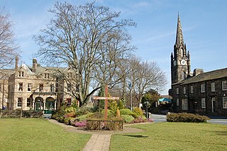
Thornton is a village and former civil parish, within the metropolitan borough of the City of Bradford, in West Yorkshire, England. It lies 6 miles (9.7 km) to the west of the city centre of Bradford, and together with neighbouring Allerton, had a total resident population in 2001 of 15,004, increasing to 17,276 in 2011 and 18,520 in 2021. Its most famous residents were the Brontës.

Thingwall is a village on the Wirral Peninsula, in Merseyside, England. The village is situated approximately 8 km (5.0 mi) to the south west of Birkenhead and 3 km (1.9 mi) north east of Heswall. Historically part of Cheshire, the area is within the Pensby and Thingwall Ward of the Metropolitan Borough of Wirral and the parliamentary constituency of Wirral West.
Clayton, or Clayton Village, is a civil parish in the City of Bradford metropolitan borough in West Yorkshire, England, situated 3 miles (4.8 km) to the west of Bradford city centre. It is listed in the Domesday Book, meaning it dates back to at least the 11th century and was privately owned from 1160 to 1866. It was noted for its clay. More recently, Clayton was a key location in the British and international wool trade, being the home of the British Wool Marketing Board headquarters. The old building was demolished and converted into housing in the late 1990s. The village re-acquired civil parish status with a parish council in 2004.

Heaton is a ward within the City of Bradford Metropolitan District Council, West Yorkshire, England. The population at the 2001 census was 16,913, which had increased to 17,121 at the 2011 Census. Historically part of the West Riding of Yorkshire, the ward includes the villages of Frizinghall, Heaton and Daisy Hill, extending to Chellow Heights Reservoir on the western edge and the Bradford-Shipley railway line on the eastern edge. Frizinghall railway station is on the edge of the ward.

Bradford West is a constituency in West Yorkshire represented in the House of Commons of the UK Parliament since 2015 by Naz Shah of the Labour Party.

Skellow is a village in the Doncaster district, in the county of South Yorkshire, England. Historically part of the West Riding of Yorkshire, the village is roughly 5 miles (8 km) north-west of Doncaster. The village falls in the Askern Spa Ward of Doncaster MBC. To the north and south is mixed farmland, the A1 runs immediately along the western edge of the village, and to the east Skellow merges with the adjacent village of Carcroft along the B1220 road.

Warley Town is a settlement near Halifax, in the Calderdale district, in the county of West Yorkshire, England. Warley is a ward of Calderdale. The population of this ward as taken at the 2011 Census was 12,215.
Burley in Wharfedale is a village and civil parish in West Yorkshire, England, in the Wharfedale valley. In 2011, it had a population of 7,041.

Thornton and Allerton is a ward within the City of Bradford Metropolitan District Council in the county of West Yorkshire, England, named after the villages of Thornton and Allerton around which it is drawn.

Thornton-le-Street is a village and parochial and civil parish in the Hambleton District of North Yorkshire, England. It is part of the civil parish of Thornton-le-Moor and Thornton-le-Street for District purposes. As the population remained less 100 at the 2011 Census details are included in the civil parish of Thornton-le-Moor. In 2015, North Yorkshire County Council estimated the population to have been 90.

Shelf is a village in Calderdale in West Yorkshire, England. The village is situated approximately 3 miles (4.8 km) north-east of Halifax and 5 miles (8 km) south-west of Bradford, on the A6036 road. In 2001 it had a population of 4,496. At the 2011 Census Shelf was measured as part of the Calderdale ward of Northowram and Shelf.
Ulley is a village and civil parish of the Metropolitan Borough of Rotherham in South Yorkshire, England. The population of the civil parish as of the 2011 census was 172. It is located about 4 miles (6 km) south of the town of Rotherham and 7 miles (11 km) east of Sheffield City Centre.

Sherburn is a village and civil parish in North Yorkshire, England. It is situated on the south side of the Vale of Pickering, immediately north of the Yorkshire Wolds. Sherburn lies 4 miles (6.4 km) north of Weaverthorpe, 3 miles (4.8 km) south of Brompton, 2 miles (3.2 km) east of East Heslerton and 2 miles (3.2 km) west of Ganton.

Paythorne is a small village and civil parish in Ribble Valley, Lancashire, England. It is situated alongside the River Ribble, north-east of Clitheroe, and on the boundary with North Yorkshire. Other parishes adjacent to Paythorne are Halton West, Nappa, Newsholme, Horton, Gisburn, Sawley, Bolton-by-Bowland and Gisburn Forest. The nearest town is Barnoldswick, situated 7 kilometres (4.3 mi) south-east of the village. Paythorne is on the edge of the Forest of Bowland Area of Outstanding Natural Beauty, although only a small area in the west of the parish is within the area's boundary. The Ribble Way long-distance walk passes through the village.
Carleton is a village on the coastal plain of the Fylde in the Borough of Wyre in Lancashire, England. It consists of Great Carleton, Little Carleton, Norcross and Whiteholme and is situated close to Poulton-le-Fylde. Other nearby settlements include Thornton, Bispham and Blackpool. Historically, Carleton was in the parish of Poulton-le-Fylde. It borders the Borough of Blackpool immediately to the west.

Harden Beck is a stream that flows from Hewenden Reservoir, over Goit Stock Waterfall to the River Aire in Bingley, West Yorkshire. The route starts out further up the valley as Denholme Beck, Hewenden Beck and Hallas Beck. Its waters are fed by Thornton Moor Reservoir, Stubden Reservoir, Doe Park Reservoir and Hewenden Reservoir.

Bradford Dale, is a side valley of Airedale that feeds water from Bradford Beck across the City of Bradford into the River Aire at Shipley in West Yorkshire, England. Whilst it is in Yorkshire and a dale, it is not part of the Yorkshire Dales and has more in common with Lower Nidderdale and Lower Airedale for its industrialisation.


