
Egypt is a hamlet near Thornton, in the City of Bradford, West Yorkshire, England.
Egypt is a hamlet near Thornton, in the City of Bradford, West Yorkshire, England.
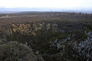
Egypt is situated about one mile (1.6 km) north-west of Thornton on a hairpin bend of a road between Well Heads and a junction with the B6144 road near Wilsden, and at the top (western) end of the marked valley of Bell Dean in which a stream runs roughly in an eastern direction. [1] High walls that were erected to hold back the waste rock from the local quarries flank the road, giving rise to the nickname "The Walls of Jericho". [2]
The hamlet was established in the first half of the 19th century and is named on maps surveyed in the late 1840s. [3] Its name may be related to the commemoration of the 1798 invasion of Egypt by the troops of Napoleon Bonaparte, [4] or the nearby Egypt Methodist Chapel which was already demolished by 1876. [5] The names of other hamlets in the area such as Jericho, Jerusalem, and World's End are also of biblical origin. [6]
Quarrying was the major industry in the area, with about 30 active quarries reported in the 1870s. [5]

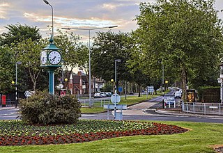
Clayton, or Clayton Village, is a civil parish in the City of Bradford metropolitan borough in West Yorkshire, England, situated 3 miles (4.8 km) to the west of Bradford city centre. It is listed in the Domesday Book, meaning it dates back to at least the 11th century and was privately owned from 1160 to 1866. It was noted for its clay. More recently, Clayton was a key location in the British and international wool trade, being the home of the British Wool Marketing Board headquarters. The old building was demolished and converted into housing in the late 1990s. The village re-acquired civil parish status with a parish council in 2004.

Skidby is a small village and civil parish in Yorkshire Wolds of the East Riding of Yorkshire, England. It is situated about 6 miles (10 km) north-west of Hull city centre, 2.2 miles (3.5 km) west of Cottingham and 5 miles (8 km) south of Beverley.

Oldfield is a small hamlet within the county of West Yorkshire, England, situated north of Stanbury and near to Oakworth. It is approximately 4 miles (6.5 km) west of the town of Keighley. It mainly consists of farmland and has panoramic views across the Worth Valley towards Brontë Country. Top Withens, the house featured in the novel Wuthering Heights, is clearly visible.
Willerby is a village and civil parish located on the western outskirts of the city of Kingston upon Hull in the East Riding of Yorkshire, England.
Anlaby Common is former common land, now an outer suburb of Kingston upon Hull. The area includes the residential areas which are located on the western urban fringe of Hull; the B1231 road passes through all of Anlaby Common's estates, east to west.

Melton is a small village in the civil parish of Welton, East Riding of Yorkshire, England. It is situated about 8 miles (13 km) west of Kingston upon Hull city centre near to the Humber Estuary and about 0.6 miles (1 km) east of the village of Welton with which it is nearly contiguous.

Brandy Carr is a hamlet in the City of Wakefield in West Yorkshire, England, north of the eponymous Brandy Carr Hill and between Balne Beck in the west and Carr Gate Beck in the east. Brandy Carr was part of Kirkhamgate civil parish and is even now considered a part of Kirkhamgate as indicated by the road signage. The nearest settlements are Carr Gate in the north, Wrenthorpe in the southeast, and Kirkhamgate in the southwest. Rhubarb and liquorice are grown at Brandy Carr Nurseries, the latter since the reintroduction of its culture to Great Britain in the early 1990s by the business owner. There are no direct public transport links to Brandy Carr, the nearest bus stops are in Kirkhamgate for services to Wakefield, and at the junction of Brandy Carr Road with the A650 road for services to Bradford, Leeds, and Wakefield.

Ferry Fryston is a suburb of the town of Castleford in West Yorkshire, England. It is situated in the metropolitan borough of the City of Wakefield. The appropriate ward is called Airedale and Ferry Fryston.

Brown Moor is an area in the metropolitan borough of the City of Leeds in West Yorkshire, England, east of Austhorpe and north of Colton. The M1 motorway and the A63 road pass it on its eastern flank and the A6120 road in the south. The area is named after a nearby hill. A colliery operated here in the 19th century and was accessed by a spur off the Leeds and Selby Railway, but was already disused in the early 20th century. At that time, some cottages had been erected nearby. Those had been sold by 2002 when Thorpe Park was established in the area.

Bowling railway station is a closed station in the city of Bradford, West Yorkshire, England. It was on the line connecting the Bradford Exchange - Low Moor line of the Lancashire and Yorkshire Railway with the line of the Great Northern Railway (GNR) at Laisterdyke. It was opened by the GNR on 1 August 1854 and closed to passengers on 1 February 1895. The line remained open to freight until 4 May 1964. No trace remains of the station which was located northeast of the bridge crossing Wakefield Road.

Dungworth is a hamlet in the civil parish of Bradfield, west of Sheffield in South Yorkshire, England.

Beggarington Hill is a hamlet in the county of West Yorkshire, England, in the City of Leeds and at the border of Kirklees. Historically, it was part of the West Ardsley civil parish. It is located immediately southwest of West Ardsley near the town of Batley, between Baghill Beck in the north and Hey Beck in the south. The A653 road runs approximately 0.6 miles (1.0 km) west of the settlement.

Lower Mickletown is a hamlet in the City of Leeds, in the English county of West Yorkshire. It was named Low Mickletown in the early 20th century and has been known under this name at least until about 1950.
Stoneferry is a suburb of Kingston upon Hull, East Riding of Yorkshire, England. It was formerly a small hamlet on the east bank of the River Hull, the site of a ferry, and, after 1905, a bridge. The area is primarily industrial, and is situated on the east bank of the river, as well as close by areas on the west bank.
Dairycoates is an area of Kingston upon Hull, East Riding of Yorkshire, England, a former hamlet.
Harden Moor is an expanse of moorland that lies north of the village of Harden in West Yorkshire, England. The moor encompasses stretches of heather, woodland and former quarry workings and is bordered by Airedale to the east, the Worth Valley to the north and Catstones Moor and the village of Cullingworth to the west. Historically, Harden Moor occupied the high ground between Bingley, Keighley, Cullingworth and Harden. Altar Lane, an unmade road which runs from the Brown Cow Inn in Bingley to Keighley Road on Harden Moor is an unofficial border between the estate of St Ives and Harden Moor, but when the St Ives Estate was created, a large swathe of Harden Moor was taken over.

Beggarington, also known as Beggerington and Begerington is a hamlet consisting of a few houses about 0.4 miles (0.6 km) north of Hartshead in Kirklees, West Yorkshire. It is situated in a bend of the B6119 road at the junction with the road from Roberttown. Beggerington has traditionally been considered a part of Hartshead. The place name means either "where the berries grow" or is related to beggar.

Bradford Dale, is a side valley of Airedale that feeds water from Bradford Beck across the City of Bradford into the River Aire at Shipley in West Yorkshire, England. Whilst it is in Yorkshire and a dale, it is not part of the Yorkshire Dales and has more in common with Lower Nidderdale and Lower Airedale for its industrialisation.

Hainworth is a hamlet 1 mile (2 km) south of Keighley in West Yorkshire, England. The hamlet faces north across the lower end of the Worth Valley with a steep wooded incline towards Keighley.

Ryecroft is a hamlet near to the village of Harden in West Yorkshire, England. The hamlet is on the road between Harden and Haworth, 1.9 miles (3 km) south of Keighley, 1.9 miles (3 km) west of Bingley and 0.6 miles (1 km) west of the centre of Harden.
| Wikimedia Commons has media related to Egypt, Bradford . |
Coordinates: 53°48′08″N1°51′43″W / 53.8023°N 1.8619°W