Cottingley, Bradford

Last updated

Cottingley
Cottingley Town Hall - geograph.org.uk - 40250.jpg
West Yorkshire UK location map.svg
Red pog.svg
Cottingley
Location within West Yorkshire
OS grid reference SE112370
Metropolitan borough
Metropolitan county
Region
Country England
Sovereign state United Kingdom
Post town BINGLEY
Postcode district BD16
Dialling code 01274
Police West Yorkshire
Fire West Yorkshire
Ambulance Yorkshire
UK Parliament
List of places
UK
England
Yorkshire
53°49′46″N1°49′51″W / 53.829504°N 1.830787°W / 53.829504; -1.830787

Cottingley is a suburban village within the City of Bradford district in West Yorkshire, England between Shipley and Bingley. It is known for the Cottingley Fairies, which appeared in a series of photographs taken there during the early 20th century.

Contents

Etymology

The village is first mentioned in the Domesday Book of 1086 as Cotingelai in the wapentake of Skyrack and the lands of Erneis of Buron. [1] The first element is the personal name Cotta (the origin of which is unknown), and the second the suffix -ingas denoting a group of associated people. Thus the Cottingas were a group descended from or otherwise associated with someone called Cotta. This group name was then compounded with the Old English word lēah ('open land in a wood'). Thus the name once meant 'the clearing of the descendants of Cola'. [2] [3]

History

The village was clustered around the original St Michael's Church, Cottingley Town Hall and the Sun Inn. This village was 2.5 miles (4 km) from Bingley, with Cottingley Bridge a mile closer. [4] [5] [6]

In 1917, two girls, 15-year old Elsie Wright and nine-year old Frances Griffiths, claimed to have photographed fairies in the dell (Cottingley Beck) at the bottom of their garden. This led to the Cottingley Fairies hoax, which still resonates in the village into the modern day. [7] The village has a festival to celebrate the story (Cottingley Fairy Fest), and in 1997, parts of a film inspired by the story, FairyTale: A True Story , were filmed in the village. [8] [9]

Governance

Cottingley is part of Bingley Rural Ward on Bradford City Council and part of the Parliamentary constituency of Shipley, represented since 2005 by the Conservative Philip Davies. At the 2011 Census, Bingley Rural Ward, which includes Cullingworth, Denholme, Harden and Wilsden, had a population of 17,895. [10]

Geography

Fairies signpost in Cottingley UK Cottingley (Bradford).jpg
Fairies signpost in Cottingley

The village is in the Aire Valley between Shipley and Bingley approximately 330 feet (100 m) above sea level with the River Aire to the north. [11] The road through the village has been changed at least twice. Originally, to exit south from Bingley, travellers had to cross Ireland Bridge then Beckfoot Bridge and approach Cottingley on the south side of the river. [12] The bridge across the River Aire leading towards Bingley was built by 1649, when it appears in the Book of Bridges in the Session Rolls of Wakefield. It was recorded in 1664 that "a great floode hath taken away the foundations so that the whole bridge is shrunke." [13] Cottingley Bridge was rebuilt and in the early 19th century, it was a hamlet independent of Cottingley. [14] [15]

The A650 road is now to the north of Cottingley after a bypass was built and opened in 2003. [16] The land to the east of the B6269 is mainly flat and to the west rises to a height of 560 feet (170 m) at March Cote Farm. [11] [17] Cottingley beck cuts a deep, narrow, rocky channel flowing north to the River Aire. [18]

Although the road, railway and the Leeds and Liverpool Canal are on the opposite side of the Aire Valley to Cottingley, Parliament was asked to consider making the Aire Navigable from Cottingley to Shipley. [19]

The village lies on Millstone Grit and there are coal deposits, some bands and seams up to 75 feet (23 m) thick. [20] Old mine shafts litter the fields either side of Cottingley Cliffe Road shown as either Old Coal Pits or Coal pits on the 1852 map, and one is listed as Cottingley Moor Bottom as having closed in 1860. [21]

Amenities

There are two churches in the village; St Mary and St Monica is the Catholic church and the Church of St Michael and All Angels is the Anglican Church. [22] St Michaels and All Angels was part of a regeneration project that spent £4.5 million, which included meeting rooms, a doctor's surgery, nursery and youth facilities and 50 new homes. The project started because a 1960s war memorial had been vandalised, and reports in the press caught the eye of Prince Charles, who came to speak at the grand unveiling. [23] [24]

The village has a primary school on Cottingley Moor Road, rated Good by OFSTED, [25] and a secondary school, Dixons Cottingley Academy. [26] Cottingley Town Hall, which is now grade II listed, celebrated its 150th anniversary in 2015. [27] [28]

Notable residents

Other notes

See also

Related Research Articles

<span class="mw-page-title-main">Bingley</span> Town in West Yorkshire, England

Bingley is a market town and civil parish in the metropolitan borough of the City of Bradford, West Yorkshire, England, on the River Aire and the Leeds and Liverpool Canal, which had a population of 18,294 at the 2011 Census.

<span class="mw-page-title-main">River Aire</span> River in Yorkshire, England

The River Aire is a major river in Yorkshire, England, 92 miles (148 km) in length. Part of the river below Leeds is canalised, and is known as the Aire and Calder Navigation.

<span class="mw-page-title-main">Riddlesden</span> Suburb in West Yorkshire, England

Riddlesden is a suburb of Keighley in the county of West Yorkshire, England and on the Leeds and Liverpool Canal.

<span class="mw-page-title-main">Shipley, West Yorkshire</span> Town and civil parish in West Yorkshire, England

Shipley is a historic market town and civil parish in the City of Bradford, West Yorkshire, England, by the River Aire and the Leeds and Liverpool Canal, north of Bradford. The population of the Shipley ward on Bradford City Council taken at the 2011 Census was 15,483.

<span class="mw-page-title-main">Baildon</span> Town and civil parish in West Yorkshire, England

Baildon is a town and civil parish in the Bradford Metropolitan Borough in West Yorkshire, England and within the historic boundaries of the West Riding of Yorkshire.

<span class="mw-page-title-main">Wilsden</span> Village and civil parish in West Yorkshire, England

Wilsden is a village and civil parish in west Bradford, in West Yorkshire, England. Wilsden is 6 miles (9.7 km) west of Bradford and is close to the Aire Valley and the nearby villages of Denholme, Cullingworth, Harden, Cottingley and Allerton. Wilsden re-acquired civil parish status in 2004. The 2001 census revealed a population of 3,697, increasing to 4,807 at the 2011 Census.

<span class="mw-page-title-main">Airedale</span>

Airedale is a geographic area in Yorkshire, England, corresponding to the river valley or dale of the River Aire.

<span class="mw-page-title-main">Bradford Canal</span> English canal

The Bradford Canal was a 3.5-mile (5.6 km) English canal which ran from the Leeds and Liverpool Canal at Shipley into the centre of Bradford. It opened in 1774, and was closed in 1866, when it was declared to be a public health hazard. Four years later it reopened with a better water supply, and closed for the second time in 1922. It was subsequently filled in, although consideration has been given to restoring it. There are some remains, including a short section of canal at the junction and a pumping station building, which is now a dwelling.

Kildwick, or Kildwick-in-Craven, is a village and civil parish of the district of Craven in North Yorkshire, England. It is situated between Skipton and Keighley and had a population of 191 in 2001, rising slightly to 194 at the 2011 census. Kildwick is a landmark as where the major road from Keighley to Skipton crosses the River Aire. The village's amenities include a primary school, church and public house.

<span class="mw-page-title-main">Church of All Saints, Bingley</span> Anglican church in Bingley, West Yorkshire, England

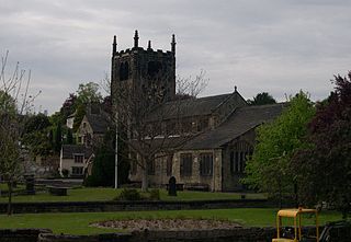
Church of All Saints is the Anglican parish church in the town of Bingley, West Yorkshire, England. It is one of two Anglican churches in the town, the other being Holy Trinity. All Saints has existed since Norman times and it is set in the oldest part of the town, near to where the River Aire is crossed by Ireland Bridge.

<span class="mw-page-title-main">Ireland Bridge</span> Listed bridge in West Yorkshire, England

Bingley's Ireland Bridge is a Grade II* listed structure and a historically significant crossing point over the River Aire in West Yorkshire, England. It is now the main route between Bingley & the nearby villages of Harden, Wilsden & Cullingworth.

<span class="mw-page-title-main">Micklethwaite, West Yorkshire</span> Village in West Yorkshire, England

Micklethwaite is a village near to Bingley in West Yorkshire, England. The village is separated from Bingley end of Crossflatts by the Leeds and Liverpool Canal. It is part of Bingley Ward, and population statistics are accounted for in the ward censuses.

<span class="mw-page-title-main">A650 road</span> Road in Yorkshire, England

A650 road is a main route through the West Yorkshire conurbation in England. The road goes from Keighley to Wakefield on a rough north west/south east axis for 25 miles (40 km). The route is mostly single carriageway with some dualled sections in the Aire Valley, Bradford and the approach to Wakefield from the M1.

<span class="mw-page-title-main">Nidd Aqueduct</span> A freshwater aqueduct in Yorkshire, England

The Nidd Aqueduct is an aqueduct or man-made watercourse in North Yorkshire, England. It feeds water from Angram and Scar House reservoirs in upper Nidderdale, North Yorkshire 32 mi (51 km) to Bradford in West Yorkshire. The aqueduct supplies 21,000,000 imp gal (95,000 m3) of water per day to Chellow Heights water treatment works. The aqueduct and the reservoirs it connects to are all maintained by Yorkshire Water.

<span class="mw-page-title-main">Harden Beck</span> Beck in West Yorkshire, England

Harden Beck is a stream that flows from Hewenden Reservoir, over Goit Stock Waterfall to the River Aire in Bingley, West Yorkshire. The route starts out further up the valley as Denholme Beck, Hewenden Beck and Hallas Beck. Its waters are fed by Thornton Moor Reservoir, Stubden Reservoir, Doe Park Reservoir and Hewenden Reservoir.

<span class="mw-page-title-main">Holy Trinity Church, Bingley</span> Anglican church in Bingley, West Yorkshire, England

Holy Trinity Church is an Anglican parish church in the town of Bingley, West Yorkshire, England notable for its original church being demolished by explosive charge on 7 April 1974.

<span class="mw-page-title-main">Harden Moor</span> Moorland in West Yorkshire, England

Harden Moor is an expanse of moorland that lies north of the village of Harden in West Yorkshire, England. The moor encompasses stretches of heather, woodland and former quarry workings and is bordered by Airedale to the east, the Worth Valley to the north and Catstones Moor and the village of Cullingworth to the west. Historically, Harden Moor occupied the high ground between Bingley, Keighley, Cullingworth and Harden. Altar Lane, an unmade road which runs from the Brown Cow Inn in Bingley to Keighley Road on Harden Moor is an unofficial border between the estate of St Ives and Harden Moor, but when the St Ives Estate was created, a large swathe of Harden Moor was taken over.

<span class="mw-page-title-main">Bradford Dale (Yorkshire)</span> Valley in West Yorkshire, England

Bradford Dale, is a side valley of Airedale that feeds water from Bradford Beck across the City of Bradford into the River Aire at Shipley in West Yorkshire, England. Whilst it is in Yorkshire and a dale, it is not part of the Yorkshire Dales and has more in common with Lower Nidderdale and Lower Airedale for its industrialisation.

<span class="mw-page-title-main">Hainworth</span> Hamlet in West Yorkshire, England

Hainworth is a hamlet 1 mile (2 km) south of Keighley in West Yorkshire, England. The hamlet faces north across the lower end of the Worth Valley with a steep wooded incline towards Keighley.

<span class="mw-page-title-main">Cottingley Town Hall</span> Municipal building in Cottingley, West Yorkshire, England

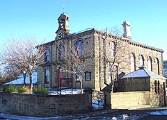
Cottingley Town Hall is a municipal building in Main Street in Cottingley, West Yorkshire, England. The building, which was used as a church and a community centre, is a Grade II listed building.

References

  1. "Cottingley | Domesday Book". opendomesday.org. Retrieved 2 March 2020.
  2. Harry Parkin, Your City's Place-Names: Leeds, English Place-Name Society City-Names Series, 3 (Nottingham: English Place-Name Society, 2017), 39.
  3. Ekwall, Eilert (1947). The concise Oxford dictionary of English place-names (3 ed.). Oxford: Clarendon Press. pp. 119, 278. OCLC   12542596.
  4. Langdale, Thomas (1822). A topographical dictionary of Yorkshire : containing the names of all the towns, villages, hamlets, gentlemen's seats, &c. in the county of York. Northallerton: J Langdale. p.  262. OCLC   963312803.
  5. "History of Cottingley, in Bradford and West Riding | Map and description". www.visionofbritain.org.uk. Retrieved 2 March 2020.
  6. 1 2 "Explore georeferenced maps - Map images - National Library of Scotland". maps.nls.uk. Retrieved 2 March 2020.
  7. Clayton, Emma (13 January 2017). "Dark side of Cottingley Fairy hoax - by family of the man who exposed it". Ilkley Gazette. Retrieved 2 March 2020.
  8. Barnett, David (17 July 2017). "Why do so many people still believe in the Cottingley Fairies?" . The Telegraph. Retrieved 2 March 2020.
  9. "Fairy Tale: A True Story". bradfordfilmheritage.com. Retrieved 2 March 2020.
  10. UK Census (2011). "Local Area Report – Bingley Rural Ward (as of 2011) (E05001343)". Nomis. Office for National Statistics . Retrieved 2 March 2020.
  11. 1 2 "288" (Map). Bradford & Huddersfield. 1:25,000. Explorer. Ordnance Survey. 2015. ISBN   9780319244852.
  12. Speight 1898, p. 75.
  13. Turner 1897, p. 186.
  14. "Cottingley bridge - Cottingley; River Aire". discovery.nationalarchives.gov.uk. Retrieved 2 March 2020.
  15. "Genuki: In 1822, the following places were in the Parish of Bingley:, Yorkshire (West Riding)". www.genuki.org.uk. Retrieved 2 March 2020.
  16. "Relief road wins top design award". BBC News. 29 October 2004. Retrieved 2 March 2020.
  17. Speight 1898, p. 96.
  18. 1 2 Speight 1898, p. 345.
  19. Journals of the House of Commons 1741 – 1745. London: House Of Commons. 1803. p. 573.
  20. Turner 1897, p. 75.
  21. "Coal Mines in Yorkshire 1854". www.nmrs.org.uk. Retrieved 2 March 2020.
  22. "St Mary and St Monica (Parish of Our Lady and St Joseph in the Aire Valley) - Cottingley". Diocese of Leeds. Retrieved 2 March 2020.
  23. Wilkinson, Paul (18 September 2008). "Cottingley 'a shining example'". www.churchtimes.co.uk. Retrieved 2 March 2020.
  24. "Prince to rededicate war memorial". BBC News. 28 September 2002. Retrieved 2 March 2020.
  25. "Cottingley Village Primary School". ofsted.gov.uk. Retrieved 2 March 2020.
  26. Lowson, Rob (3 July 2018). "Academy chain launches new school and confirms sixth form site". Bradford Telegraph and Argus. Retrieved 2 March 2020.
  27. Historic England. "Town Hall (Grade II) (1314305)". National Heritage List for England . Retrieved 2 March 2020.
  28. Tate, Chris (13 March 2015). "Celebrations for 150th anniversary of Cottingley Town Hall". Bradford Telegraph and Argus. Retrieved 2 March 2020.
  29. Clayton, Emma (17 September 2009). "A true story". Bradford Telegraph and Argus. Retrieved 2 March 2020.
  30. Harding, Colin. "Griffiths, Frances". Oxford Dictionary of National Biography (online ed.). Oxford University Press. doi:10.1093/ref:odnb/58057.(Subscription or UK public library membership required.)
  31. Turner 1897, pp. 202, 309.

Sources