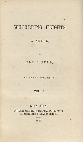
Wuthering Heights is the only novel by the English author Emily Brontë, initially published in 1847 under her pen name "Ellis Bell". It concerns two families of the landed gentry living on the West Yorkshire moors, the Earnshaws and the Lintons, and their turbulent relationships with the Earnshaws' foster son, Heathcliff. The novel, influenced by Romanticism and Gothic fiction, is considered a classic of English literature.

Haworth is a village in West Yorkshire, England, in the Pennines 3 miles (5 km) south-west of Keighley, 8 miles (13 km) north of Halifax, 10 miles (16 km) west of Bradford and 10 miles (16 km) east of Colne in Lancashire. The surrounding areas include Oakworth and Oxenhope. Nearby villages include Cross Roads, Stanbury and Lumbfoot.

Brontë Country is a name given to an area of south Pennine hills west of Bradford in West Yorkshire, England. The name comes from the Brontë sisters, who wrote such literary classics as Jane Eyre, Wuthering Heights, and The Tenant of Wildfell Hall while living in the area.

Brontë Waterfall on the South Dean Beck is about a mile south-west of Stanbury, near Haworth in West Yorkshire, England. Beck is a dialect word for a stream. The waterfall is known to have been appreciated by the Brontë sisters.

The River Worth is a river in West Yorkshire, England. It flows from minor tributaries on the moors above Watersheddles Reservoir down the Worth Valley to Haworth, where it is joined by Bridgehouse Beck which flows from Oxenhope. The River Worth is itself a tributary of the River Aire, which it joins at the end of the Worth Valley in Keighley.

The Brontë Parsonage Museum is a writer's house museum maintained by the Brontë Society in honour of the Brontë sisters – Charlotte, Emily and Anne. The museum is in the former Brontë family home, the parsonage in Haworth, West Yorkshire, England, where the sisters spent most of their lives and wrote their famous novels.

Worth Valley is a ward in the City of Bradford Metropolitan District Council, West Yorkshire. The population of the ward taken at the 2011 Census was 14,387. It is named after the River Worth that runs through the valley to the town of Keighley where it joins the River Aire. In the north it is bounded by North Yorkshire, in the west by Lancashire and in the south by Calderdale District.

Oldfield is a small hamlet within the county of West Yorkshire, England, situated north of Stanbury and near to Oakworth. It is approximately 6 miles (9.2 km) west of the town of Keighley. It mainly consists of farmland and has panoramic views across the Worth Valley towards Brontë Country. Top Withens, the house featured in the novel Wuthering Heights, is clearly visible.
Top Withens is a ruined farmhouse near Haworth, West Yorkshire, England, which is said to have helped inspire Emily Brontë's novel Wuthering Heights. It occupies a high and remote position on Haworth Moor, 1,377 feet above sea level. The name comes from a dialect word meaning "willows".

High Sunderland Hall was a medieval manor house clad in stone c. 1600. It was located just outside Halifax, West Yorkshire and demolished in 1951 after falling into dereliction. The house is perhaps best known for having supposedly provided Emily Brontë with her description of Wuthering Heights, the house in her eponymous novel. The building stood just a few miles from Law Hill House, Southowram, where she spent some time as a school mistress. It was home to the Sunderland family from perhaps as early as the 12th century.

Cross Roads or Cross Roads with Lees or Cross Roads cum Lees is a village and civil parish within the City of Bradford Metropolitan District, West Yorkshire, England. Historically part of the West Riding of Yorkshire, it lies less than 1 mile (1.6 km) from Haworth, approximately 2.5 miles (4 km) from Keighley and approximately 9 miles (14 km) from Bradford.

Ponden Hall is a farmhouse near Stanbury in West Yorkshire, England. It is famous for reputedly being the inspiration for Thrushcross Grange, the home of the Linton family, Edgar, Isabella, and Cathy, in Emily Brontë's novel Wuthering Heights since Bronte was a frequent visitor. However, it does not match the description given in the novel and is closer in size and appearance to the farmhouse of Wuthering Heights itself.

Scar Top is a farming hamlet near the tourist village of Haworth in the City of Bradford metropolitan borough, West Yorkshire in England. It is in the BD22 postcode area. Located west of Stanbury on a minor road connecting Haworth to Laneshaw Bridge, the hamlet contains a chapel, a farm and a collection of cottages; an infrequent bus service, route 916, runs to Keighley. Scar Top Chapel and Sunday School was built in 1869, replacing one built in 1818; it formerly belonged to the Methodists but since the 1970s has been independent. Ponden Mill, on the road to Haworth, was one of the main employers in the area. Moor Lodge, located northwest of the hamlet, is a former shooting lodge, built by Amos Nelson, that has been converted to a furniture and gift shop and tearooms'. It is thought to be the inspiration behind Ferndean Manor in Charlotte Brontë's 'Jane Eyre".
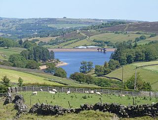
Lower Laithe Reservoir is a man-made upland reservoir that lies 1.2 miles (2 km) west of Haworth, West Yorkshire, England. The reservoir was initially approved under the Keighley Waterworks and Improvement Act of 1869 but work did not begin on its construction until 1911 and even then was delayed because of the First World War. The reservoir was officially opened in August 1925 in front of a crowd of over 8,000 people. Its final tally on cost was £500,000. The reservoir lies in the Sladen Valley and was often referred to as Sladen Valley Reservoir.

Penistone Hill Country Park is an open space of moorland that is located to 0.31 miles (0.5 km) west of Haworth and 0.62 miles (1 km) north-west of Oxenhope in West Yorkshire, England. The park's highest point is detailed with a trig point which is 1,030 feet (310 m) above sea level. Since 1994, the park has been notified as being an SSSI as part of the South Pennine Moors.

Laycock is a small village in the Bradford District of West Yorkshire that overlooks the hamlet of Goose Eye. The village is 1.9 miles (3 km) west of the town of Keighley and 1.2 miles (2 km) north of Oakworth village. The village is in the council ward of Keighley West.

Hainworth is a hamlet 1 mile (2 km) south of Keighley in West Yorkshire, England. The hamlet faces north across the lower end of the Worth Valley with a steep wooded incline towards Keighley.

Ponden Reservoir is an artificial upland lake in the Worth Valley, near Stanbury, West Yorkshire, England. Ponden was built as a compensation reservoir after the nearby Watersheddles Reservoir (upstream) was used to divert water away from the River Worth. Ponden was needed to regulate the flow of water down the river into the downstream mills in the valley.

The Worth Valley is a geographic area in West Yorkshire, England, that extends eastwards from Crow Hill and Oxenhope Moor, providing drainage for the River Worth for nearly 10 miles (16 km) to the River Aire. It is a side valley to Airedale, with the River Worth being a major tributary of the River Aire. The Worth Valley was important for its contribution to the textiles industry of the West Riding of Yorkshire and was furnished with several reservoirs to allow mills to operate within the valley. Most of the reservoirs are still in use into the modern day.

Watersheddles Reservoir is an upland artificial lake in Lancashire, England. The reservoir was opened in 1877 by the Keighley Corporation Water Works, and is now owned by Yorkshire Water. It supplies water to the Worth Valley and Keighley area and compounds several streams at the source of the River Worth.
 Main Street. Quaker Burial Ground.
 Main Street, Wuthering Heights PH.
 Main Street, St.Gabriel's Church.
 Main Street, former Methodist Chapel.


