53°51′43″N1°53′49″W / 53.862°N 1.897°W
Contents

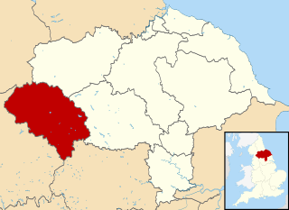
Long Lee and Thwaites Brow is a suburb about one mile to the south east of the centre of the town of Keighley, West Yorkshire, England.
53°51′43″N1°53′49″W / 53.862°N 1.897°W
Long Lee and Thwaites Brow is a suburb about one mile to the south east of the centre of the town of Keighley, West Yorkshire, England.

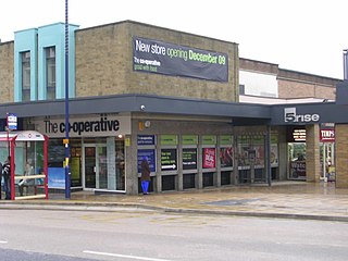
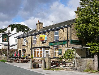
Long Lee is a partially rural area which encompasses a primary school, a public house, a church, a chapel, a doctor's surgery, a pharmacy, a convenience store with off-licence and a Scout Group Consisting of Beavers, Cubs and Scouts. It is a large residential area with many buildings ranging from bungalows to mansions.
Long Lee is situated in the Keighley East ward of the City of Bradford Metropolitan District Council and is represented by three Labour Party Councillors. The area also forms part of the Long Lee & Parkwood ward of Keighley Town Council.
Long Lee and Thwaites Brow are served by the Keighley Bus Company bus route K5 which connects the area with Keighley Bus Station which runs at least once an hour in both directions 7 days a week.
Long Lee lies on the busy but unclassified road from Keighley to Harden which forms part of an alternative route to Bradford.

West Yorkshire is a ceremonial county in the Yorkshire and the Humber region of England. It borders North Yorkshire to the north and east, South Yorkshire and Derbyshire to the south, Greater Manchester to the south-west, and Lancashire to the west. The city of Leeds is the largest settlement.
Bingley is a market town and civil parish in the metropolitan borough of the City of Bradford, West Yorkshire, England, on the River Aire and the Leeds and Liverpool Canal, which had a population of 18,294 at the 2011 Census.

Keighley is a market town and a civil parish in the City of Bradford Borough of West Yorkshire, England. It is the second largest settlement in the borough, after Bradford.

Tong is a ward within the City of Bradford Metropolitan District Council, West Yorkshire, England, named after Tong village which is its oldest settlement. The population at the 2011 Census was 20,608.
Craven was a non-metropolitan district in the west of North Yorkshire, centred on the market town of Skipton.

The City of BradfordMetropolitan District, commonly called the Bradford, is a local government district of West Yorkshire, England, with the status of a city and metropolitan borough. It is named after its largest settlement, Bradford, but covers a large area which includes the towns and villages of Keighley, Shipley, Bingley, Ilkley, Haworth, Silsden, Queensbury, Thornton and Denholme. Bradford has a population of 528,155, making it the fourth-most populous metropolitan district and the sixth-most populous local authority district in England. It forms part of the West Yorkshire Urban Area conurbation which in 2011 had a population of 1,777,934, and the city is part of the Leeds-Bradford Larger Urban Zone (LUZ), which, with a population of 2,393,300, is the fourth largest in the United Kingdom after London, Birmingham and Manchester.

Cullingworth is a village and civil parish in the City of Bradford, West Yorkshire, England. Within the boundaries of the historic West Riding of Yorkshire, it is 7 miles (11 km) west of Bradford and 3 miles (5 km) south of Keighley. The surrounding countryside is mainly used for sheep and cattle farming, with areas of moorland lying to the north and west.

Keighley is a constituency in West Yorkshire created in 1885 represented in the House of Commons of the UK Parliament since 2019 by Robbie Moore of the Conservative Party.


Ingrow is a suburb of Keighley, West Yorkshire, England that lies on the River Worth. The name Ingrow comes from Old Scandinavian which means 'corner of land in the meadow.' The suburb is located on the A629 road and is 0.93 miles (1.5 km) south west of Keighley town centre.

The West Yorkshire Road Car Company was a major bus operator operating in North and West Yorkshire between 1906 and 1987.
The Queensbury lines was the name given to a number of railway lines in West Yorkshire, England, that linked Bradford, Halifax and Keighley via Queensbury. All the lines were either solely owned by the Great Northern Railway (GNR) or jointly by the GNR and the Lancashire and Yorkshire Railway (L&YR). The terrain was extremely challenging for railway construction, and the lines were very expensive to build. The lines were

Frizinghall is a district in the Heaton ward of the City of Bradford, West Yorkshire, lying 2 miles (3 km) north of the city centre close to the town of Shipley, itself a part of the City of Bradford Metropolitan District along with such other nearby towns as Keighley and Ilkley.

Steeton is a village in the City of Bradford metropolitan borough, West Yorkshire, England. Historically part of the West Riding of Yorkshire, it is situated approximately 5 miles (8 km) south-east from Skipton, 3 miles (5 km) north-west from Keighley and just south of the A629 road. The village is part of Steeton with Eastburn civil parish.
Keighley Tramways Company operated a tramway service in Keighley between 1889 and 1901 with horse power. The system re-opened three days later as Keighley Corporation Tramways and stayed in service until 1924 when it closed for good.

A650 road is a main route through the West Yorkshire conurbation in England. The road goes from Keighley to Wakefield on a rough north west/south east axis for 25 miles (40 km). The route is mostly single carriageway with some dualled sections in the Aire Valley, Bradford and the approach to Wakefield from the M1.

Thwaites railway station was a railway station located just east of Keighley, West Riding of Yorkshire, on the Midland Railway line through the Aire Valley between Keighley and Shipley. It opened to traffic in 1892 and closed 17 years later in 1909 due to poor patronage.
| | This West Yorkshire location article is a stub. You can help Wikipedia by expanding it. |