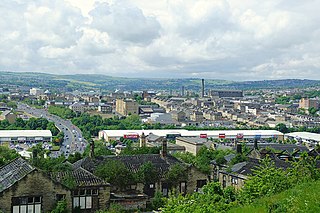
Manningham is a historically industrial workers area as well as a council ward of Bradford, West Yorkshire, England. The population of the 2011 Census for the Manningham Ward was 19,983.
Corporation Park is a traditional Victorian park in Blackburn, Lancashire, England. It was landscaped by William Henderson and opened in 1857. Corporation Park is regarded as the main formal park in Blackburn and is used mainly by local people for general recreation, walking and dog walking, as well as for its tennis, bowling and football facilities.

Eccleshill is an area, former village, and ward within the Bradford district, in the county of West Yorkshire, England. The ward population of Eccleshill is 17,540, increasing at the 2011 Census to 17,945. Eccleshill is a more or less completely residential urban area with very little open space although there is substantial open land directly to the east.
Lister Park is a picturesque public park in Bradford, West Yorkshire, England, between Manningham, Heaton and Frizinghall. It has won various national awards.

East Bowling is an area of Bradford, West Yorkshire, England located to the south of Bradford city centre. It forms the eastern half of the historic township and manor of Bowling. Bowling became a ward of the newly created Borough of Bradford in 1847. In 1882 the ward was split into the wards of East and West Bowling. In the north the boundary was along the Lancashire and Yorkshire Railway. To the south it was along Hall Lane and Bolling Hall Lane.

Undercliffe Cemetery is located between Otley Road and Undercliffe Lane in the Bolton and Undercliffe ward, Bradford, West Yorkshire, England. The cemetery stands atop a hillside overlooking the city and contains some very impressive Victorian funerary monuments in a variety of styles. It is a notable example of a Victorian cemetery where a number of rich and prominent local residents have been buried, notably mill owners and former mayors. Undercliffe Cemetery is grade II* listed by English Heritage in their Register of Parks and Gardens of Special Historic Interest in England.

Squares have long been a feature of London and come in numerous identifiable forms. The landscaping spectrum of squares stretches from those with more hardscape, constituting town squares —to those with communal gardens, for which London is a major international exponent, known as garden squares. London's largest privately-owned square is Vincent Square, in Westminster, which comprises 13 acres.

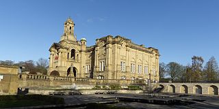
Cusworth Hall is an 18th-century Grade I listed country house in Cusworth, near Doncaster, South Yorkshire in the north of England. Set in the landscaped parklands of Cusworth Park, Cusworth Hall is a good example of a Georgian country house. It is now a country house museum.

Horsfall Community Stadium is a sports stadium just off Halifax Road in Bradford, West Yorkshire, England, 2.5 miles (4.0 km) south-west of the city centre. It is the home of Bradford A.F.C. Albion Sports A.F.C. and West Bowling ARLFC

Holden Park is the only park in the village of Oakworth, West Yorkshire, England. The park is also known locally as Oakworth Park.

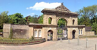
Peel Park is a 22.6-hectare (56-acre) urban public park in the Bolton and Undercliffe area of Bradford, England, located about 0.75 miles (1.2 km) north-east of the city centre, and named after Sir Robert Peel (1788–1850). Peel Park was Bradford's first public park and is on the English Heritage and National Register of Historic Parks and Gardens online databases. The park is a Green Flag Award winner and has been for a number of years.

Horton Park is a public park in Bradford, England, located to the South of the city in Great Horton. It was opened on 25 May 1878 on land purchased by Bradford Council in 1873. The park was designed by William Gay landscape gardener and surveyor.

Thackley is a small suburb near Bradford, West Yorkshire in England. The village is loosely bordered by the village of Idle to the south, to the west by the West Royd area of Shipley and elsewhere by the Leeds and Liverpool Canal. Thackley is the northernmost part of Bradford south of the River Aire.

Ward Jackson Park is a municipal park located in Hartlepool, England. It is named after Ralph Ward Jackson, a local industrialist, who founded West Hartlepool in the 19th century. In later life, Ward Jackson encountered financial difficulties and a fund was established to help him out in his old age. In view of his sudden death, the money collected was used to create a public park. It is Grade II listed in Historic England's Register of Parks and Gardens.

Parc Howard Museum & Art Gallery is a museum in a 19th-century Italianate country house, situated in 24 acres (9.7 ha) of parkland, north of the town centre of Llanelli in Carmarthenshire, Wales. The park is registered on the Cadw/ICOMOS Register of Parks and Gardens of Special Historic Interest in Wales.

Bank Hall Gardens comprise 18 acres (73,000 m2) of curtilage at Bank Hall, in Bretherton, Lancashire, England. The gardens contain specimen trees including a yew thought to be the oldest in Lancashire. Many architectural features, statues, low garden walls, conservatory and greenhouses have gone but there are plans to recreate them. The Bank Hall Action Group has tended the grounds since its formation in 1995. The group has planted specimen trees and identified the flora and fauna. The group opened the gardens to the public in 1999 after building a security fence, erecting scaffolding to secure the building and clearing the overgrowth. New varieties of snowdrops, some of which are unique to the gardens were uncovered. After a visit from the Snowdrop Society in 2007 the garden has become nationally known for snowdrop carpets during February.

Barkerend is an inner-city area of Bradford, West Yorkshire, England, east of the city centre and surrounded by Undercliffe Cemetery, Bradford Moor, Laisterdyke, Bowling, Broomfields, Little Germany and Wapping, including an area of modern housing known as Pollard Park.

Broomfields is a historic district on the south eastern edge of Bradford, West Yorkshire, England. In 1840 it was still a mainly rural area with a population of only a few hundred people. By 1880 it was one of the most densely populated districts of Bradford with 1,500 houses, a population of about 8,000 and many commercial premises. In 1932 a process of slum clearance and commercial regeneration was started. Today (2014) the district is almost wholly given over to commercial premises and once again has a resident population of only about two hundred people.

Roberts Park is a 14 acres (5.7 ha) public urban park in Saltaire, West Yorkshire, England. Higher Coach Road, Baildon, is to the north and the park is bounded to the south by the River Aire. A pedestrian footbridge crosses the Aire and links the park to the village of Saltaire. The park is an integral part of the Saltaire World Heritage site.

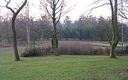
Harold Park is a small urban park in Low Moor, Bradford, West Yorkshire, England. The park is open all day all year round. To the immediate north of Harold Park is Horsfall Stadium home to Bradford Park Avenue A.F.C. and Albion Sports A.F.C. Park Dam is a short walking distance to the south.

 Bowling Hall Road

