
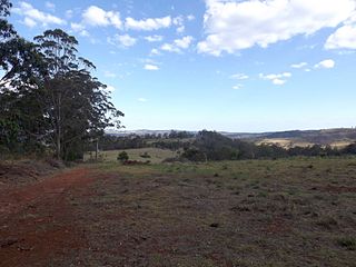
Crows Nest National Park is a national park on the edge of the Darling Downs of southern Queensland, Australia. It is divided into a number of sections which are located in both Crows Nest and Grapetree, 40 km west of Esk in the South East Queensland bioregion. A 236 ha national park was first declared in 1967. The park has been extended south along the Great Dividing Range and now covers 17.9 km2 (6.91 sq mi). The average elevation of the terrain is 503 meters.

The Wildlife and Countryside Act 1981 is an Act of Parliament in the United Kingdom implemented to comply with European Council Directive 79/409/EEC on the conservation of wild birds. In short, the act gives protection to native species, controls the release of non-native species, enhances the protection of Sites of Special Scientific Interest and builds upon the rights of way rules in the National Parks and Access to the Countryside Act 1949. The Act is split into 4 parts covering 74 sections; it also includes 17 schedules.
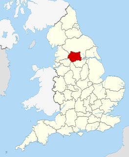
West Yorkshire is a metropolitan and ceremonial county in England. It is an inland and, in relative terms, upland county having eastward-draining valleys while taking in the moors of the Pennines. West Yorkshire came into existence as a metropolitan county in 1974 after the passage of the Local Government Act 1972 and has a population of 2.3 million. Its largest settlements are Leeds, Bradford, Huddersfield, Wakefield, Halifax, Keighley and Dewsbury.

Dewsbury is a minster and market town in the Metropolitan Borough of Kirklees in West Yorkshire, England. It lies on the River Calder and on an arm of the Calder and Hebble Navigation waterway. It is to the west of Wakefield, east of Huddersfield and south of Leeds.

Kirklees is a local government district of West Yorkshire, England, governed by Kirklees Council with the status of a metropolitan borough. The largest town and administrative centre of Kirklees is Huddersfield, and the district also includes Batley, Birstall, Cleckheaton, Denby Dale, Dewsbury, Heckmondwike, Holmfirth, Kirkburton, Marsden, Meltham, Mirfield and Slaithwaite. Kirklees had a population of 422,500 in 2011; it is also the third largest metropolitan district in England by area size, behind Doncaster and Leeds.

The house crow, also known as the Indian, greynecked, Ceylon or Colombo crow, is a common bird of the crow family that is of Asian origin but now found in many parts of the world, where they arrived assisted by shipping. It is between the jackdaw and the carrion crow in size but is slimmer than either. The forehead, crown, throat and upper breast are a richly glossed black, whilst the neck and breast are a lighter grey-brown in colour. The wings, tail and legs are black. There are regional variations in the thickness of the bill and the depth of colour in areas of the plumage.

Crows Nest is a suburb on the lower North Shore of Sydney, New South Wales, Australia. It is also part of the North Sydney region, 5 kilometres north of the Sydney central business district, in the local government area of North Sydney Council.

Kraaifontein is a town in the Western Cape province of South Africa. Organisationally and administratively it is included in the City of Cape Town Metropolitan Municipality as a Northern Suburb. The name originated from large number of crows that nest in the region.
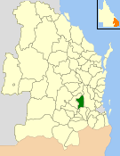
The Shire of Crows Nest was a local government area in the Darling Downs region of Queensland, Australia, immediately northeast of the regional city of Toowoomba. The shire, administered from the town of Crows Nest, covered an area of 1,629.9 square kilometres (629.3 sq mi), and existed as a local government entity from 1913 until 2008, when it amalgamated with several other councils in the Toowoomba area to form the Toowoomba Region. Its growth in later years has been fuelled by the expansion of Toowoomba, particularly the suburbs of Highfields and Blue Mountain Heights which, with a combined population of 7,333 in 2006, were home to over half the shire's population.
Lightcliffe is a village in West Yorkshire, England. Historically part of the West Riding of Yorkshire, it is situated approximately three miles east of Halifax and two miles north west of Brighouse in the metropolitan district of Calderdale. It was created a separate parish in 1846.

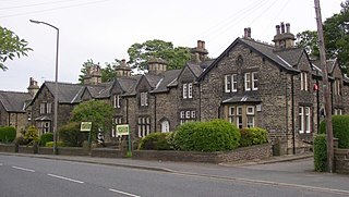
Boothroyd is a village located west of Dewsbury in the Metropolitan Borough of Kirklees, West Yorkshire, England.

La Vraie-Croix is a commune in the Morbihan department in Brittany in north-western France. Its inhabitants are called Langroëziens after the Breton name for the commune.

Crows Nest is a rural town and locality in the Toowoomba Region, Queensland, Australia. The town is located in the Darling Downs on the New England Highway, 158 kilometres (98 mi) from the state capital, Brisbane and 43 kilometres (27 mi) from the nearby city of Toowoomba. In the 2016 census, Crows Nest had a population of 2160 people.

Crow's Nest Natural Area Preserve is a large wilderness area located on the southern border of Stafford County, Virginia, United States, between Potomac Creek and Accokeek Creek. The greater portion of the Crow's Nest Peninsula is approximately 3,800 acres (15 km2) and lies within the coastal plain of Virginia. About 2,872 acres (11.62 km2) of the peninsula is protected as part of the Virginia Natural Area Preserve System.

Crow's Nest is a mountain along the west bank of the Hudson River in the Town of Highlands on the northern edge of the United States Military Academy (USMA) at West Point. US 9W passes just west of its summit and offers panoramic views of the Hudson River, the military academy's ski slope, and Constitution Island.

Crows Nest Post Office is a heritage-listed post office at 19 Curnow Street, Crows Nest, Toowoomba Region, Queensland, Australia. It was built in 1911. It was added to the Queensland Heritage Register on 27 June 2003.
Grapetree is a rural locality in the Toowoomba Region, Queensland, Australia. In the 2016 census Grapetree had a population of 32 people.

Cammeraygal High School is a government-funded co-educational comprehensive secondary day school, located on the Pacific Highway, Crows Nest, a suburb on the lower north shore of Sydney, New South Wales, Australia.
Crows Nest Boys High School is a former high school located at 365 Pacific Highway in the Sydney suburb of Crows Nest, New South Wales, Australia. It was a boys' high school operated by the New South Wales Department of Education with students from years 7 to 12. The school was first established in 1883 as St Leonards North Public School. However, the school was declared surplus to the needs of the department and officially closed in 1992. The school and its heritage-listed buildings are now the campus of North Sydney Girls High School.
Dewsbury is a town and an unparished area in the metropolitan borough of Kirklees, West Yorkshire, England. It contains 128 listed buildings that are recorded in the National Heritage List for England. Of these, two are listed at Grade I, the highest of the three grades, two are at Grade II*, the middle grade, and the others are at Grade II, the lowest grade. The list consists of the listed buildings in the town and the countryside to the south, and includes the districts, villages and smaller settlements of Boothroyd, Briestfield, Hanging Heaton, Overthorpe, Ravensthorpe, Thornhill, and Whitley Lower.

