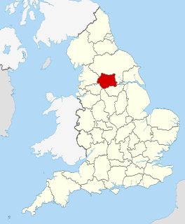
West Yorkshire is a metropolitan and ceremonial county in England. It is an inland and, in relative terms, upland county having eastward-draining valleys while taking in the moors of the Pennines. West Yorkshire came into existence as a metropolitan county in 1974 after the passage of the Local Government Act 1972 and has a population of 2.3 million.

Baildon is a town and civil parish in the Bradford Metropolitan Borough in West Yorkshire, England and within the historic boundaries of the West Riding of Yorkshire.

Yeadon is a town within the metropolitan borough of the City of Leeds, West Yorkshire, England.

Gathorne Gathorne-Hardy, 1st Earl of Cranbrook,, known as Gathorne Hardy until 1878, was a prominent British Conservative politician, a moderate, middle-of-the road Anglican. He held cabinet office in every Conservative government between 1858 and 1892 and notably served as Home Secretary from 1867 to 1868 and as Secretary of State for War from 1874 to 1878.
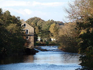
Addingham is a village and civil parish in the English county of West Yorkshire. It is situated near the A65, 6 miles (10 km) south east of Skipton, 3 miles (5 km) west of Ilkley, 19 miles (31 km) north west of Bradford and around 20 miles (32 km) north west of Leeds. Historically part of the West Riding of Yorkshire, it is located in the valley of the River Wharfe and is only 1 mile (2 km) from the Yorkshire Dales National Park. The name is thought to mean "homestead associated with a man called Adda", although in the Domesday Book, the village was referred to as "Ediham", which may have referred to Earl Edwin of Bolton Abbey. The 2001 census numbered Addingham's population at 3,599, increasing to 3,730 at the 2011 Census.
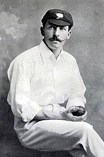
Frank William Milligan was an English amateur first-class cricketer, who played in two Tests in 1899. He died in the campaign to relieve Mafeking during the Second Boer War.

Crosland Moor is a district of the town of Huddersfield, West Yorkshire, England.

Undercliffe Cemetery is located between Otley Road and Undercliffe Lane in the Bolton and Undercliffe ward, Bradford, West Yorkshire, England. The cemetery stands atop a hillside overlooking the city and contains some very impressive Victorian funerary monuments in a variety of styles. It is a notable example of a Victorian cemetery where a number of rich and prominent local residents have been buried, notably mill owners and former mayors. Undercliffe Cemetery is grade II* listed by English Heritage in their Register of Parks and Gardens of Special Historic Interest in England.

Cod Beck Reservoir is a man-made lake situated within the North York Moors National Park and near the village of Osmotherley in the English county of North Yorkshire. The reservoir is named after Cod Beck, which is the small river that fills it.

John Hardy was a British businessman and Member of Parliament.

Sir John Hardy, 1st Baronet, was a British Conservative Member of Parliament.

Harden is a civil parish and village within the City of Bradford Metropolitan District, West Yorkshire, England, 2 miles (3.2 km) west of Bingley. It had a population of 1,615 in the 2001 census, but by 2011 this had risen to 1,900.

Peel Park is a 22.6-hectare (56-acre) urban public park in the Bolton and Undercliffe area of Bradford, England, located about 0.75 miles (1.2 km) north-east of the city centre, and named after Sir Robert Peel (1788–1850). Peel Park was Bradford's first public park and is on the English Heritage and National Register of Historic Parks and Gardens online databases. The park is a Green Flag Award winner and has been for a number of years.
Caroline Gathorne-Hardy, Countess of Cranbrook is an English aristocrat and campaigner on food quality issues. She is the wife of Gathorne Gathorne-Hardy, 5th Earl of Cranbrook.

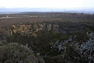
Penistone Hill Country Park is an open space of moorland that is located to 0.31 miles (0.5 km) west of Haworth and 0.62 miles (1 km) north-west of Oxenhope in West Yorkshire, England. The park's highest point is detailed with a trig point which is 1,030 feet (310 m) above sea level. Since 1994, the park has been notified as being an SSSI as part of the South Pennine Moors.
Harden Moor is an expanse of moorland that lies north of the village of Harden in West Yorkshire, England. The moor encompasses stretches of heather, woodland and former quarry workings and is bordered by Airedale to the east, the Worth Valley to the north and Catstones Moor and the village of Cullingworth to the west. Historically, Harden Moor occupied the high ground between Bingley, Keighley, Cullingworth and Harden. Altar Lane, an unmade road which runs from the Brown Cow Inn in Bingley to Keighley Road on Harden Moor is an unofficial border between the estate of St Ives and Harden Moor, but when the St Ives Estate was created, a large swathe of Harden Moor was taken over.

Bradford Dale, is a side valley of Airedale that feeds water from Bradford Beck across the City of Bradford into the River Aire at Shipley in West Yorkshire, England. Whilst it is in Yorkshire and a dale, it is not part of the Yorkshire Dales and has more in common with Lower Nidderdale and Lower Airedale for its industrialisation.

The Spen Valley Line was a railway that connected Mirfield with Low Moor through the Spen Valley in West Yorkshire, England. Opened up by the Lancashire and Yorkshire Railway in 1847, with full opening to Low Moor in 1848, the line served a busy industrial and textile area and allowed a connection for trains between Huddersfield and Bradford. The line was absorbed by the London & North Western Railway, the London Midland and Scottish Railway (LMS) and British Railways on Nationalisation. A separate link between Heckmondwike Central and Thornhill that opened later and was known as the Ravensthorpe Branch, allowed through running to Wakefield and beyond. The line was closed down to passengers in 1965 with freight continuing sporadically until 1981. A Spur onto the former Leeds New Line from the Ravensthorpe Branch kept the very southern end open until the late 1980s. The majority of the route is now the Spen Valley Greenway cycle path.

Catherine Mawer was an architectural sculptor who worked alongside her husband Robert Mawer, then following his death in 1854 she ran the family stone yard as a master sculptor at Great George Street, Leeds, West Yorkshire, England, until 1859. The other master sculptor in her 1854–1859 company, which was known as Mrs Mawer, was her nephew William Ingle who supervised the stone yard and onsite works from 1854. Her apprentices were Matthew Taylor, Benjamin Payler, and her son Charles Mawer. All the apprentices later had independent careers as sculptors. After her son came of age in 1870, she continued working alongside Charles and her nephew William in the partnership Mawer and Ingle at the same address. Catherine was a founder member of the Mawer Group, which comprised all of the above Leeds architectural sculptors. During her lifetime, the Mawer group produced some strongly lifelike and often unflattering portraits, full of movement, including portraits of men with overhanging moustaches and cavernous mouths. These portraits continued after the deaths of Robert Mawer and William Ingle, but stopped appearing at her death in 1877. It is therefore reasonable to conclude that this style of work was her own.
Gathorne Gathorne-Hardy, 5th Earl of Cranbrook,, styled Lord Medway until 1978, is a British zoologist, biologist, naturalist, and peer. Since 1956, he has been active in the fields of ornithology, mammalogy, and zooarchaeology, and has influenced research and education in Southeast Asia. His career focus was on the tiny birds that build edible nests.

