
Shipley is a historic market town and civil parish in the City of Bradford, West Yorkshire, England.

Shepherd's Bush is a suburb of West London, England, within the London Borough of Hammersmith and Fulham 4.9 miles (7.9 km) west of Charing Cross, and identified as a major metropolitan centre in the London Plan.
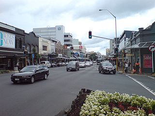
Newmarket is an Auckland suburb to the south-east of the central business district. With its high building density, especially of retail shops, it is considered New Zealand's premier retailing area, and a rival of local competitor Auckland CBD.

Arndale Centres were the first "American style" malls to be built in the United Kingdom. In total, Arndale Property Trust built 23 Arndale Centres in the United Kingdom, and three in Australia. The first opened in Jarrow, County Durham, in 1961, as a pedestrianised shopping area.

Wakefield Kirkgate railway station is a railway station in Wakefield, West Yorkshire, England. Unlike the nearby Wakefield Westgate railway station, Kirkgate is unstaffed. The station is managed by Northern but also served by Grand Central and TransPennine Express. It is on the Hallam, Calder Valley, Pontefract and Huddersfield lines. It has a limited number of services to London King's Cross.

Wakefield Westgate railway station is a mainline railway station in Wakefield, West Yorkshire, England. It is 10 miles (16 km) south of Leeds to the west of the city centre, on the Wakefield Line and Leeds branch of the East Coast Main Line.

Bradford Forster Square railway station serves Bradford, West Yorkshire, England. The majority of services to and from the station use Class 333 electric multiple units operated by Northern Trains; they run on the Airedale line to Skipton, the Wharfedale line to Ilkley and the Leeds-Bradford line to Leeds.

Skidby is a small village and civil parish in Yorkshire Wolds of the East Riding of Yorkshire, England. It is situated about 6 miles (10 km) north-west of Hull city centre, 2.2 miles (3.5 km) west of Cottingham and 5 miles (8 km) south of Beverley.

Bradford Interchange is a transport interchange in Bradford, West Yorkshire, England, which consists of a railway station and bus station adjacent. The Interchange, which was designed in 1962, was hailed as a showpiece of European design and was opened on 14 January 1973. It is served by the majority of bus services in the city centre, while the railway station, which is one of two in the city centre, is served by Northern and is also the terminus for Grand Central services from London King's Cross.

Woodville is a large suburban village and civil parish that crosses two districts - South Derbyshire district of Derbyshire and North West Leicestershire district of Leicestershire, England, 2 miles (3.2 km) east of Swadlincote. At the 2011 Census, the parish had a population of 5,161, an increase from 3,420 at the 2001 Census. The centre of the village, known as the Tollgate, is a busy traffic island on the A511. Woodville forms part of the border with Leicestershire.

Idle is a residential suburban area in the city of Bradford, West Yorkshire, in England and was a separate village, and before that it was the Manor of Idle. Idle is loosely bordered by the areas of Eccleshill, Wrose, Thackley, Apperley Bridge, and Greengates, in the north-east of the city.

The recorded history of Wetherby, a market town in the City of Leeds metropolitan borough, West Yorkshire, England, began in the 12th and 13th centuries, when the Knights Templar and later the Knights Hospitallers were granted land and properties in Yorkshire. The preceptory founded in 1217 was at Ribston Park. In 1240, the Knights Templar were granted by the Royal Charter of Henry III the right to hold a market in Wetherby. The charter stated the market should be held on Thursdays, and an annual fair was permitted lasting three days over the day of St James the Apostle.

The Broadway is a shopping and leisure complex in the centre of Bradford, West Yorkshire, England, which opened on 5 November 2015. It was built and was operated, in its first year, by the Westfield Corporation but is owned by Ellandi. It is currently operated by Munroe K Asset Management Ltd.
Bradford is a city in West Yorkshire, England. It became a municipal borough in 1847, received a city charter in 1897 and, since the 1974 reform, the city status has belonged to the larger City of Bradford metropolitan borough. It had a population of 349,561 at the 2011 census, making it the second-largest subdivision of the West Yorkshire Built-up Area after Leeds, which is approximately 9 miles (14 km) to the east. The borough had a population of 552,644, making it the 9th most populous district in England.

A truncated railway station terminus an original railway station site that is sold for redevelopment and a new, usually smaller station is being constructed back down the line. There are many examples of station buildings and other structures, such as the redundant platforms at Whitby, being sold for redevelopment. The truncation however, was only partial, as one platform still survives in its original location. Many stations have had platforms truncated to accommodate larger concourses, such as London King's Cross and London Liverpool Street This article, however, is about new stations that have been fully truncated and cut short from a former location.

Bradford Crossrail is an idea to link together Bradford's two railway stations, Bradford Forster Square and Bradford Interchange. Both these stations are truncated versions of former station sites, Bradford Forster Square station and Bradford Exchange. These stations were built in the nineteenth century by different railway companies with an individual, rather than a comprehensive plan for rail development in the city.

The Excalibur Estate was a post-war 1940s housing estate of 189 prefabricated houses in Catford, South London. The estate contained the last sizeable collection of post-war prefabricated houses in the United Kingdom. In 2011, Lewisham Council approved a plan to replace the prefabs with 371 houses, with demolition scheduled to begin in 2013. English Heritage has granted listed building status to six of the "prefab" houses. The proposed demolition led to campaigns by residents, English Heritage and the Twentieth Century Society to save the properties, with an unsuccessful legal challenge to prevent redevelopment, and a return to parkland, if they were demolished. Apart from the six with Grade II listing, all the buildings are due for demolition, and the redeveloped estate completed, by the mid 2020's.

Bradford Dale, is a side valley of Airedale that feeds water from Bradford Beck across the City of Bradford into the River Aire at Shipley in West Yorkshire, England. Whilst it is in Yorkshire and a dale, it is not part of the Yorkshire Dales and has more in common with Lower Nidderdale and Lower Airedale for its industrialisation.
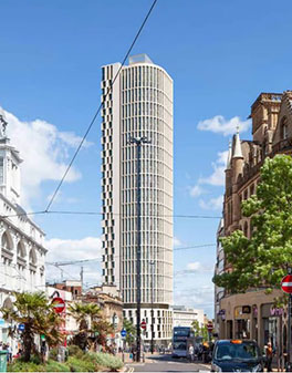
Kings Tower is an approved skyscraper that will be located on Castle Square at the junction of High Street and Angel Street in Sheffield, South Yorkshire. With a planned height of 120 m (390 ft) once completed, Kings Tower will overtake Code Sheffield, and St Pauls Tower as the tallest building in Sheffield and in Yorkshire. Plans for the tower were submitted by architects Hodder + Partners in September 2020, calling initially for a 39-storey tower. Planning permission was granted in December 2020, and construction is planned to complete in 2023. Amended plans were submitted in late 2022, adding a 40th floor to the project.

Kirkgate is a street in the city centre of Wakefield, in West Yorkshire, in England.

