
Haworth is a village in City of Bradford, West Yorkshire, England, in the Pennines, 3 miles (5 km) south-west of Keighley, 10 miles (16 km) west of Bradford and 10 miles (16 km) east of Colne in Lancashire. The surrounding areas include Oakworth and Oxenhope. Nearby villages include Cross Roads, Stanbury and Lumbfoot.

Oxenhope is a village and civil parish near Keighley in the metropolitan borough of Bradford, West Yorkshire, England. The population was 2,476 at the time of the 2001 census which had increased to 2,626 at the 2011 Census. Historically part of the West Riding of Yorkshire, Oxenhope railway station is the terminus for the Keighley and Worth Valley Railway.

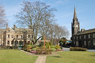
Keighley is a market town and a civil parish in the City of Bradford Borough of West Yorkshire, England. It is the second largest settlement in the borough, after Bradford.

Stanbury is a village in the Haworth, Cross Roads and Stanbury civil parish, and in the metropolitan borough of the City of Bradford in West Yorkshire, England. The name Stanbury translates as Stone Fort from Old English.

The River Worth is a river in West Yorkshire, England. It flows from minor tributaries on the moors above Watersheddles Reservoir down the Worth Valley to Haworth, where it is joined by Bridgehouse Beck which flows from Oxenhope. The River Worth is itself a tributary of the River Aire, which it joins at the end of the Worth Valley in Keighley.

Oldfield is a small hamlet within the county of West Yorkshire, England, situated north of Stanbury and near to Oakworth. It is approximately 6 miles (9.2 km) west of the town of Keighley. It mainly consists of farmland and has panoramic views across the Worth Valley towards Brontë Country. Top Withens, the house featured in the novel Wuthering Heights, is clearly visible.
Burley in Wharfedale is a village and a civil parish in the City of Bradford in West Yorkshire, England. It is situated in the Wharfedale valley.

Appletreewick is a village and civil parish in the Craven district of North Yorkshire, England, 12 miles (19 km) north-east of Skipton, 7 miles (11 km) from Skipton railway station and 16 miles (25.7 km) from Leeds Bradford International Airport.
Haworth, Cross Roads and Stanbury is a civil parish covering the far western hinterland of the City of Bradford in West Yorkshire, England. According to the 2001 census the parish had a population of 6,566, increasing to 6,994 at the 2011 Census. As its name suggests, it covers Haworth, Cross Roads and Stanbury, with a large moorland area to the west of Stanbury. In total, the civil parish covers 1,737 hectares.

The Blackburn Brook is a stream in Sheffield, South Yorkshire, England which flows through the Blackburn Valley along the M1 and Ecclesfield Road and joins the River Don near the Meadowhall shopping centre. Downstream from the A61 road at Chapeltown the Blackburn Brook is defined as a main river by the Environment Agency, which requires new building development to be at least 26 feet (8 m) from the bank side as a flood defence measure and to allow access to the watercourse for maintenance.

Cross Roads with Lees or Cross Roads cum Lees is a village in the Haworth, Cross Roads and Stanbury civil parish within the City of Bradford Metropolitan District, West Yorkshire, England. Historically part of the West Riding of Yorkshire, it lies less than 1-mile (1.6 km) from Haworth, approximately 2.5 miles (4 km) from Keighley and approximately 9 miles (14 km) from Bradford.

St Michael and All Angels' Church is the Church of England parish church of Haworth, West Yorkshire. The current structure, the third church building on the site, was built between 1879 and 1881 although parts of the original medieval church building, notably the tower, survive from earlier periods.

Scar Top is a farming hamlet near the tourist village of Haworth in the City of Bradford metropolitan borough, West Yorkshire in England. It is in the BD22 postcode area. Located west of Stanbury on a minor road connecting Haworth to Laneshaw Bridge, the hamlet contains a chapel, a farm and a collection of cottages; an infrequent bus service, route 916, runs to Keighley. Scar Top Chapel and Sunday School was built in 1869, replacing one built in 1818; it formerly belonged to the Methodists but since the 1970s has been independent. Ponden Mill, on the road to Haworth, was one of the main employers in the area. Moor Lodge, located northwest of the hamlet, is a former shooting lodge, built by Amos Nelson, that has been converted to a furniture and gift shop and tearooms'. It is thought to be the inspiration behind Ferndean Manor in Charlotte Brontë's 'Jane Eyre".
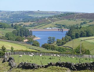
Lower Laithe Reservoir is a man-made upland reservoir that lies 1.2 miles (2 km) west of Haworth, West Yorkshire, England. The reservoir was initially approved under the Keighley Waterworks and Improvement Act of 1869 but work did not begin on its construction until 1911 and even then was delayed because of the First World War. The reservoir was officially opened in August 1925 in front of a crowd of over 8,000 people. Its final tally on cost was £500,000. The reservoir lies in the Sladen Valley and was often referred to as Sladen Valley Reservoir.

Penistone Hill Country Park is an open space of moorland that is located to 0.31 miles (0.5 km) west of Haworth and 0.62 miles (1 km) north-west of Oxenhope in West Yorkshire, England. The park's highest point is detailed with a trig point which is 1,030 feet (310 m) above sea level. Since 1994, the park has been notified as being an SSSI as part of the South Pennine Moors.

Laycock is a small village in the Bradford District of West Yorkshire that overlooks the hamlet of Goose Eye. The village is 1.9 miles (3 km) west of the town of Keighley and 1.2 miles (2 km) north of Oakworth village. The village is in the council ward of Keighley West.

Hainworth is a hamlet 1 mile (2 km) south of Keighley in West Yorkshire, England. The hamlet faces north across the lower end of the Worth Valley with a steep wooded incline towards Keighley.

Ryecroft is a hamlet near to the village of Harden in West Yorkshire, England. The hamlet is on the road between Harden and Haworth, 1.9 miles (3 km) south of Keighley, 1.9 miles (3 km) west of Bingley and 0.6 miles (1 km) west of the centre of Harden.

The Worth Valley is a geographic area in West Yorkshire, England, that extends eastwards from Crow Hill and Oxenhope Moor, providing drainage for the River Worth for nearly 10 miles (16 km) to the River Aire. It is a side valley to Airedale, with the River Worth being a major tributary of the River Aire. The Worth Valley was important for its contribution to the textiles industry of the West Riding of Yorkshire and was furnished with several reservoirs to allow mills to operate within the valley. Most of the reservoirs are still in use into the modern day.
Haworth, Cross Roads and Stanbury is a civil parish in the metropolitan borough of the City of Bradford, West Yorkshire, England. It contains 86 listed buildings that are recorded in the National Heritage List for England. Of these, one is listed at Grade I, the highest of the three grades, two are at Grade II*, the middle grade, and the others are at Grade II, the lowest grade. The parish contains the villages of Haworth, Cross Roads and Stanbury, and the surrounding countryside. Most of the listed buildings are houses, cottages and associated structures, farmhouses, farm buildings, and shops. Haworth has associations with the Brontë family who lived in Haworth Parsonage, which is listed at Grade I. The other listed buildings include churches, chapels and associated structures, textile mills, bridges, public houses, a milepost, a former school, a railway station, a war memorial and a memorial building, and three telephone kiosks.


