
The M4, originally the London-South Wales Motorway, is a motorway in the United Kingdom running from west London to southwest Wales. The English section to the Severn Bridge was constructed between 1961 and 1971, and the Welsh element was completed in 1993. On the opening of the Second Severn Crossing in 1996, the M4 was rerouted over it.

The M62 is a 107-mile-long (172 km) west–east trans-Pennine motorway in Northern England, connecting Liverpool and Hull via Manchester and Leeds; 7 miles (11 km) of the route is shared with the M60 orbital motorway around Manchester. The road is part of the unsigned Euroroutes E20 and E22.
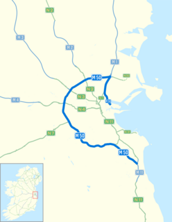
The M50 motorway is a C-shaped orbital motorway in Dublin and the busiest motorway in Ireland. The current route was built in various sections over the course of 27 years, from 1983 to 2010. It begins at Dublin Port, running northward through the Dublin Port Tunnel and along a portion of the Airport Motorway. It then turns west at its junction with the M1, circling the northern, western and southern suburbs of Dublin, before merging with the M11 at Shankill in South East Dublin. The road forms part of European route E01.

The island of Ireland, comprising Northern Ireland and the Republic of Ireland, has an extensive network of tens of thousands of kilometres of public roads, usually surfaced. These roads have been developed and modernised over centuries, from trackways suitable only for walkers and horses, to surfaced roads including modern motorways. The major routes were established before Irish independence and consequently take little cognisance of the border other than a change of identification number and street furniture. Northern Ireland has had motorways since 1962, and has a well-developed network of primary, secondary and local routes. The Republic started work on its motorway network in the early 1980s; and historically, the road network there was once somewhat less well developed. However, the Celtic Tiger economic boom and an influx of European Union structural funding, saw national roads and regional roads in the Republic come up to international standard quite quickly. In the mid-1990s, for example, the Republic went from having only a few short sections of motorway to a network of motorways, dual carriageways and other improvements on most major routes as part of a National Development Plan. Road construction in Northern Ireland now tends to proceed at a slower pace than in the Republic, although a number of important bypasses and upgrades to dual carriageway have recently been completed or are about to begin.

The A63 is a major road in Yorkshire, England between Leeds and Kingston upon Hull. A section between North Cave and Hull forms the eastward continuation of the M62 motorway and is part of the unsigned Euroroute E20.

The Leeds Inner Ring Road is part-motorway and part-A roads in Leeds, West Yorkshire, England, which forms a ring road around the city centre. It has six different road numbers that are all sections of longer roads. Clockwise, the roads are the A58(M), a motorway section of the A58 road; the A64(M), part of the A64 road; the A61 between York Road and the M621; the M621 between junctions 4 and 2; and the A643 between the M621 and A58. The motorway section is in total is 2.5 miles (4.0 km) long and is subject to a 40 miles per hour (64 km/h) speed limit throughout.

A limited-access road, known by various terms worldwide, including limited-access highway, dual-carriageway, expressway, and partial controlled access highway, is a highway or arterial road for high-speed traffic which has many or most characteristics of a controlled-access highway, including limited or no access to adjacent property, some degree of separation of opposing traffic flow, use of grade separated interchanges to some extent, prohibition of some modes of transport such as bicycles or horses, and very few or no intersecting cross-streets or level crossings. The degree of isolation from local traffic allowed varies between countries and regions. The precise definition of these terms varies by jurisdiction.

Oakenshaw is a village near Cleckheaton in the City of Bradford metropolitan district and Kirklees, West Yorkshire, England.

European route E20 is a part of the United Nations International E-road network. It runs roughly west–east through Ireland, the United Kingdom, Denmark, Sweden, Estonia, and Russia.

The N18 road is a national primary road in Ireland, connecting the cities of Limerick and Galway. Ennis and Gort are two major towns on the route, and Shannon Airport is reached via the connecting N19. The west coast route continues on to Sligo as the N17. The section from Limerick to the N19 junction forms part of European route E20, and the entire route is part of the proposed Atlantic Corridor. The section of motorway from Shannon to Claregalway is designated the M18 motorway. The tolled Limerick Tunnel forms part of the route.

A controlled-access highway is a type of highway that has been designed for high-speed vehicular traffic, with all traffic flow—ingress and egress—regulated. Common English terms are freeway, motorway and expressway. Other similar terms include throughway and parkway. Some of these may be limited-access highways, although this term can also refer to a class of highway with somewhat less isolation from other traffic.

The M606 is a short stretch of motorway in West Yorkshire, England. Called the Bradford Spur motorway, the M606 leaves the M62 motorway at junction 26, near Cleckheaton, and heads into Bradford, to join the A6177 Bradford Ring Road. It is officially named the "Bradford South Radial Motorway" and was opened in 1973.

The A453 road was formerly the main trunk road connecting the English cities of Nottingham and Birmingham. However, the middle section of this mainly single-carriageway road has largely been downgraded to B roads or unclassified roads following the construction of the parallel M42-A42 link around 1990. The M42 was originally meant to pass further north than it does, and to join the M1 at Sandiacre in Derbyshire. The M42/A42 does not enter Derbyshire, but instead joins the M1 closer to the A453 junction at Kegworth. The A42 shadows the former A453 from Appleby Magna to Castle Donington. The road historically connected the East Midlands with the West Midlands.

Heston services is a motorway service station on the M4 motorway in the London Borough of Hounslow, built on land that once formed part of the now defunct Heston Aerodrome.

The A638 is a main road in England that runs between the A1 at Markham Moor in Nottinghamshire and Chain Bar Junction 26 of the M62 motorway south of Bradford in West Yorkshire.

The A5103 is a major road in England. It runs from Piccadilly Gardens in Manchester city centre to junction 3 of the M56 motorway and is one of Manchester's principal radial routes.

The A4232, which is also known either as the Peripheral Distributor Road (PDR) or the Cardiff Link Road, is a distributor road in Cardiff, the capital of Wales.
A roundabout interchange is a type of interchange between a controlled access highway, such as a motorway or freeway, and a minor road. The slip roads to and from the motorway carriageways converge at a single roundabout, which is grade-separated from the motorway lanes with bridges.
Liverpool in North West England, is a major British city with significant road, rail, and ferry networks, in addition to an international airport and a well-known dock system. As with most other major UK cities, Liverpool's transport infrastructure is centred on its road and rail networks. Public transport services within the city are controlled and run by Merseytravel.

The Milton Keynes Coachway is a Coachway interchange close to junction 14 of the M1 Motorway on the eastern edge of Milton Keynes, north Buckinghamshire, England. It supports National Express intercity coach services to cities, towns and airports on the M1, M6, and on into Scotland, to Heathrow, Gatwick, Stansted and Luton Airports, as well as Stagecoach East's route X5 between Oxford and Cambridge, and interchange between these services. There are also local bus services and nearby, a park and ride site. It is the second busiest coach station in the United Kingdom. Dating from 1989, it was the first of the UK's Coachway interchanges.

