Ponden Reservoir

Last updated

Ponden Reservoir
Ponden Reservoir (5897560301).jpg
Ponden Reservoir
West Yorkshire UK relief location map.jpg
Red pog.svg
Ponden Reservoir
Location Stanbury, West Yorkshire, England
Coordinates 53°49′48″N2°00′36″W / 53.830°N 2.010°W / 53.830; -2.010
Type Compensation
Primary outflows River Worth
Catchment area 2,540 acres (1,027 ha)
Built1871–1876
Surface area25 acres (10 ha)
Water volume30,500,000 cubic feet (865,000 m3)
Shore length11.2 miles (2 km)
Surface elevation768 feet (234 m)
References [1]
1 Shore length is not a well-defined measure.

Ponden Reservoir is an artificial upland lake in the Worth Valley, near Stanbury, West Yorkshire, England. Ponden was built as a compensation reservoir after the nearby Watersheddles Reservoir (upstream) was used to divert water away from the River Worth. Ponden was needed to regulate the flow of water down the river into the downstream mills in the valley.

Contents

The reservoir is owned and managed by Yorkshire Water, and is used as a recreational waterbody by a sailing club.

History

Ponden Reservoir was completed in 1876 as a compensation reservoir on the River Worth in West Yorkshire. [2] An estimate in 1853 accounted for 16 mills between the site of Ponden Reservoir and where the River Worth ended in Keighley. [3] The tender for construction of Ponden (and Watersheddles) was awarded to Walker and Taylor of Crewe in June 1870. [4] But the construction was beset by problems with the puddle trench (needed for the dam wall), being sunk to a depth of 67 feet (20 m) before finding rock. Other issues with building the reservoir changed the original timeline from 1 year and nine months, to five years. [5] By 1874, the height of the dam wall had been built to a height of 26 feet (7.9 m), and 222 men were working on the project. [6]

The influx of navvies to construct both Watersheddles and Ponden reservoirs, created a separate local industry; brewing. It was said that the navvies needed two things; beef and beer, [7] and a brewery was built to service their needs at Scar Top, which was at the north eastern end of the dam wall at Ponden Reservoir. [8]

Keighley Corporation Water Works operated the reservoir until 1959, when it was amalgamated into the newly created Craven Water Board (CWB). [9] The CWB, itself, was subsumed into Yorkshire Water in 1974. [10] [11] In 2022, Yorkshire Water commissioned a 1.2 miles (1.9 km) pipeline to connect Walshaw Dean Upper Reservoir to Ponden Reservoir, which allows for the transfer of water to Ponden. During the 2022 drought, this enabled reservoir levels at Ponden to be increased from a 20% low, to 80%. [12]

Hydrology and wildlife

The Worth Valley reservoirs and their drinking water supply. Worth Valley reservoirs.svg
The Worth Valley reservoirs and their drinking water supply.

Water for Ponden Reservoir either flows downstream from Watersheddles reservoir, or through the streams that feed the reservoir separately. One of the major tributaries is Ponden Clough, which flows over sandstone beds, typically composed of grit, mudstone and Keighley Bluestone (a hard wearing stone used in road building locally). [13] A catchment tower was built at the head of Ponden Clough which takes water away from the stream and straight into Watersheddles by the means of a conduit. [14]

The water quality of Ponden is rated as moderate for ecological purposes, and good for its chemical composition, by the Environment Agency. [15] The surrounding peatland contributes to the discolouration of the water held in the reservoir. [16] Water from Ponden is now supplied to two water treatment works at Oldfield and Sladen Valley, as well as regulating the flow of water into the River Worth. [17] Water from Ponden is only pumped to Oldfield WTW if the supply from Watersheddles is disrupted in any way. [18]

The River Worth is noted for the presence of brook lamprey, which have been recorded just south of Ponden Bridge. [19] In 2017-2018, a fish pass was installed into the reservoir. [20] Canada geese are often seen on the reservoir, and reports of mink on the edges have been prevalent since the 1980s. [21]

Leisure

Ponden Water Sports Club use the site for canoeing, sailboarding and sailing. [22]

Related Research Articles

<span class="mw-page-title-main">Haworth</span> Village in West Yorkshire, England

Haworth is a village in West Yorkshire, England. Located in the Pennines, Haworth is 3 miles (5 km) south-west of Keighley, 8 miles north of Halifax, 10 miles (16 km) west of Bradford and 10 miles (16 km) east of Colne in Lancashire. The surrounding areas include Oakworth and Oxenhope. Nearby villages include Cross Roads, Stanbury and Lumbfoot.

<span class="mw-page-title-main">Keighley</span> Market town and civil parish in West Yorkshire, England

Keighley is a market town and a civil parish in the City of Bradford Borough of West Yorkshire, England. It is the second largest settlement in the borough, after Bradford.

<span class="mw-page-title-main">Stanbury</span> Village in West Yorkshire, England

Stanbury is a village and former civil parish, now in the parish of Haworth and Stanbury, in the metropolitan borough of the City of Bradford in West Yorkshire, England. In 1931 the parish had a population of 453. The name Stanbury translates as Stone Fort from Old English.

<span class="mw-page-title-main">River Worth</span> River in West Yorkshire, England

The River Worth is a river in West Yorkshire, England. It flows from minor tributaries on the moors above Watersheddles Reservoir down the Worth Valley to Haworth, where it is joined by Bridgehouse Beck which flows from Oxenhope. The River Worth is itself a tributary of the River Aire, which it joins at the end of the Worth Valley in Keighley.

<span class="mw-page-title-main">Yorkshire Water</span> Water supply and treatment utility company in England

Yorkshire Water is a water supply and treatment utility company servicing West Yorkshire, South Yorkshire, the East Riding of Yorkshire, part of North Lincolnshire, most of North Yorkshire and part of Derbyshire, in England. The company has its origins in the Yorkshire Water Authority, one of ten regional water authorities created by the Water Act 1973, and privatised under the terms of the Water Act 1989, when Yorkshire Water plc, the parent company of the Yorkshire Water business, was floated on the London Stock Exchange. The parent company was Kelda Group in 1999. In February 2008, Kelda Group was bought by a consortium of infrastructure funds.

<span class="mw-page-title-main">Angram Reservoir</span> Reservoir in North Yorkshire, England

Angram Reservoir is the first of three reservoirs on the River Nidd in Upper Nidderdale, North Yorkshire, England, the others being Scar House Reservoir and finally the compensation reservoir Gouthwaite Reservoir. It is located at OS map reference SE040759. Between them they attract around 150,000 visitors a year.

<span class="mw-page-title-main">Cackleshaw</span> Hamlet in West Yorkshire, England

Cackleshaw is a hamlet in West Yorkshire, England. It is located about one-third of a mile (0.5 km) east of Oakworth in the Worth Valley area of the City of Bradford. The name of the hamlet has been recorded historically as Cackeleshawe, Cackelshay, Cackwelshey and Cockleshaw. This derives from the Old English of kakele and Sceagh, which means copse.

<span class="mw-page-title-main">Cross Roads, West Yorkshire</span> Village in West Yorkshire, England

Cross Roads or Cross Roads with Lees or Cross Roads cum Lees is a village and civil parish within the City of Bradford Metropolitan District, West Yorkshire, England. Historically part of the West Riding of Yorkshire, it lies less than 1 mile (1.6 km) from Haworth, approximately 2.5 miles (4 km) from Keighley and approximately 9 miles (14 km) from Bradford.

<span class="mw-page-title-main">Baitings Reservoir</span> Reservoir in West Yorkshire, England

Baitings Reservoir is a large water supply reservoir operated by Yorkshire Water close to Ripponden in the West Yorkshire Pennines, England. It lies in the valley of the River Ryburn and is the higher of two reservoirs built to supply Wakefield with water and was completed in 1956. The lower reservoir is Ryburn Reservoir.

<span class="mw-page-title-main">Embsay Reservoir</span> Reservoir in North Yorkshire, England

Embsay Reservoir is located above the village of Embsay, near Skipton in the Yorkshire Dales in North Yorkshire, England. It is owned by Yorkshire Water, and supplies water to the north and west of Skipton, feeding 25,000 homes. It has a dam height of 24 m (79 ft).

<span class="mw-page-title-main">Lower Laithe Reservoir</span> Reservoir in West Yorkshire, England

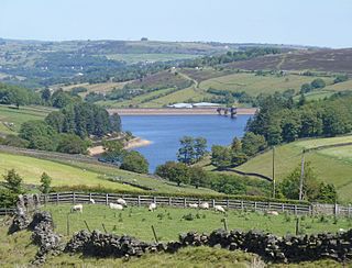
Lower Laithe Reservoir is a man-made upland reservoir that lies 1.2 miles (2 km) west of Haworth, West Yorkshire, England. The reservoir was initially approved under the Keighley Waterworks and Improvement Act of 1869 but work did not begin on its construction until 1911 and even then was delayed because of the First World War. The reservoir was officially opened in August 1925 in front of a crowd of over 8,000 people. Its final tally on cost was £500,000. The reservoir lies in the Sladen Valley and was often referred to as Sladen Valley Reservoir.

<span class="mw-page-title-main">Penistone Hill Country Park</span> Moorland park in West Yorkshire, England

Penistone Hill Country Park is an open space of moorland that is located to 0.31 miles (0.5 km) west of Haworth and 0.62 miles (1 km) north-west of Oxenhope in West Yorkshire, England. The park's highest point is detailed with a trig point which is 1,030 feet (310 m) above sea level. Since 1994, the park has been notified as being an SSSI as part of the South Pennine Moors.

<span class="mw-page-title-main">Winscar Reservoir</span> Reservoir in South Yorkshire, England

Winscar Reservoir, is a compensation reservoir on the headwaters of the River Don in South Yorkshire, England. The reservoir is located at Dunford Bridge, 25 miles (40 km) northwest of Sheffield, and is just inside the Peak District National Park on the Pennine watershed. The reservoir was built on an existing dam and has suffered from leaking which necessitated a new membrane being installed at the dam head in the years 2000 and 2001.

<span class="mw-page-title-main">Yorkshire Water Way</span>

The Yorkshire Water Way is a 104-mile (167 km) path that runs from Kettlewell in North Yorkshire to Langsett in South Yorkshire. It was devised by Mark Reid in conjunction with Yorkshire Water (YW) and it passes by over more than 20 reservoirs which are operated by Yorkshire Water.

<span class="mw-page-title-main">Hainworth</span> Hamlet in West Yorkshire, England

Hainworth is a hamlet 1 mile (2 km) south of Keighley in West Yorkshire, England. The hamlet faces north across the lower end of the Worth Valley with a steep wooded incline towards Keighley.

<span class="mw-page-title-main">Worth Valley (dale)</span> Valley in West Yorkshire, England

The Worth Valley is a geographic area in West Yorkshire, England, that extends eastwards from Crow Hill and Oxenhope Moor, providing drainage for the River Worth for nearly 10 miles (16 km) to the River Aire. It is a side valley to Airedale, with the River Worth being a major tributary of the River Aire. The Worth Valley was important for its contribution to the textiles industry of the West Riding of Yorkshire and was furnished with several reservoirs to allow mills to operate within the valley. Most of the reservoirs are still in use into the modern day.

<span class="mw-page-title-main">Watersheddles Reservoir</span> Reservoir in Lancashire, England

Watersheddles Reservoir is an upland artificial lake in Lancashire, England. The reservoir was opened in 1877 by the Keighley Corporation Water Works, and is now owned by Yorkshire Water. It supplies water to the Worth Valley and Keighley area and compounds several streams at the source of the River Worth.

<span class="mw-page-title-main">Hedon Haven</span> River and port in the East Riding of Yorkshire, England

Hedon Haven is a waterway that connected the Humber Estuary with the port of Hedon, in Holderness, East Riding of Yorkshire, England. The waterway allowed ships to unload at the port in Hedon, which was also known as Hedon Haven and had, at its peak, three canalised arms that stretched into the town. The port at Hedon was the main port for south Holderness between the 12th and 13th centuries, and was the busiest port in Holderness before the docks at Hull were built.

<span class="mw-page-title-main">Upper Barden Reservoir</span> Freshwater reservoir in North Yorkshire, England

Upper Barden Reservoir is an upland fresh water reservoir, one of two reservoirs that collect water from Barden Moor, and dam Barden Beck, a tributary of the River Wharfe in the Yorkshire Dales, North Yorkshire, England. The reservoir was opened in 1882 and also supplies fresh water to the Nidd Aqueduct, which transports it to Bradford. Upper Barden Reservoir was the second of the reservoirs to be built,.

<span class="mw-page-title-main">Oak Beck</span> River in North Yorkshire, England

Oak Beck is a watercourse that flows eastwards across the northern part of Harrogate in North Yorkshire, England. The beck flows through a broad V-shaped valley, before emptying into the River Nidd at Bilton, just upstream from the Nidd Gorge Viaduct. Water from Oak Beck has been used as a water supply for Harrogate and also for industrial purposes further downstream.

References

  1. "Ponder[sic] Reservoir Water Body ID 30489". eip.ceh.ac.uk. Archived from the original on 11 June 2016. Retrieved 2 September 2020.
  2. Hewitt 1985, p. 124.
  3. "The Bradford Water Works Bill". The Bradford Observer. No. 1, 002. Column E. 5 May 1853. p. 5.
  4. "Keighley Local Board". The Bradford Observer. No. 2, 332. Column E. 15 June 1870. p. 3.
  5. Dewhirst, Ian (5 February 2009). "Ponden puddle scene was set for a rip-roaring era" . infoweb.newsbank.com. Retrieved 4 September 2020.
  6. "Keighley Local Board". The Bradford Observer. No. 3, 572. Column C. 10 June 1874. p. 3.
  7. Hewitt 1985, p. 125.
  8. Wood & Palmer 2009, p. 88.
  9. "Looking Back Friday, August 29, 2008" . infoweb.newsbank.com. 29 August 2008. Retrieved 4 September 2020.
  10. "Craven's long, hot summer when the rain never came". Craven Herald. 5 September 2009. Retrieved 4 September 2020.
  11. "Craven through the years" . infoweb.newsbank.com. 13 June 1998. Retrieved 4 September 2020.
  12. Mitchinson, James (7 December 2022). "Yorkshire hosepipe ban lifted as wetter than average autumn fills reservoirs". The Yorkshire Post. p. 6. ISSN   0963-1496.
  13. "Ponden Clough, Haworth" (PDF). wyorksgeologytrust.org. Retrieved 2 September 2020.
  14. Wood & Palmer 2009, p. 91.
  15. "Ponden Reservoir". environment.data.gov.uk. Retrieved 2 September 2020.
  16. "PR19 – Yorkshire Water's submission to DWI" (PDF). yorkshirewater.com. December 2017. p. 37. Retrieved 4 September 2020.
  17. "Drinking Water Quality DWI Submission; Long-term Statement on Drinking Water Quality" (PDF). yorkshirewater.com. May 2018. p. 42. Retrieved 4 September 2020.
  18. "PR19 – Yorkshire Water's submission to DWI" (PDF). yorkshirewater.com. December 2017. p. 42. Retrieved 4 September 2020.
  19. Sunderland, Kevin (December 2013). "River Aire Fish Populations 2012". The Naturalist. 138 (1, 084). York: Yorkshire Naturalists' Union: 166. ISSN   0028-0771.
  20. "Biodiversity Action Plan 2017-2018" (PDF). yorkshirewater.com. p. 4. Retrieved 4 September 2020.
  21. Hewitt 1985, p. 33.
  22. "Recreational Tenants | Yorkshire Water". www.yorkshirewater.com. Retrieved 4 September 2020.

Sources