
Pateley Bridge is a market town in Nidderdale in the county and district of North Yorkshire, England. Historically part of the West Riding of Yorkshire, it lies on the River Nidd. It is in the Yorkshire Dales and just outside the Yorkshire Dales National Park.

Great Whernside is a fell in the Yorkshire Dales, England, not to be confused with Whernside, some 17 miles (27 km) to the west. Its summit is the highest point of the eastern flank of Wharfedale above Kettlewell. Great Whernside forms the watershed between Wharfedale and Nidderdale, and is on the boundary between the Yorkshire Dales National Park and Nidderdale Area of Outstanding Natural Beauty. The River Nidd rises on the eastern slopes of Great Whernside, above Angram Reservoir.

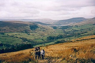
Nidderdale, historically also known as Netherdale, is one of the Yorkshire Dales in North Yorkshire, England. It is the upper valley of the River Nidd, which flows south underground and then along the dale, forming several reservoirs including the Gouthwaite Reservoir, before turning east and eventually joining the River Ouse.
The Nidderdale AONB is an Area of Outstanding Natural Beauty in North Yorkshire, England, bordering the Yorkshire Dales National Park to the east and south. It comprises most of Nidderdale itself, part of lower Wharfedale, the Washburn valley and part of lower Wensleydale, including Jervaulx Abbey and the side valleys west of the River Ure. It covers a total area of 233 square miles (600 km2). The highest point in the Nidderdale AONB is Great Whernside, 704 metres (2,310 ft) above sea level, on the border with the Yorkshire Dales National Park.
Birstwith is a village and civil parish in the Harrogate district of North Yorkshire, England. It is part of the Nidderdale, and is situated on the River Nidd. According to the 2001 census, the parish had a population of 756 and increased to 868 based on the 2011 Census.

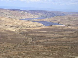
The River Nidd is a tributary of the River Ouse in the English county of North Yorkshire. In its first few miles it is dammed three times to create Angram Reservoir, Scar House Reservoir and Gouthwaite Reservoir, which attract a total of around 150,000 visitors a year. The Nidd can overflow the reservoirs, flooding the caves in the valley. In such cases the river overflows into the normally dry river bed past Lofthouse through to Gouthwaite Reservoir. The Yorkshire Dales Rivers Trust YDRT has a remit to conserve the ecological condition of the River Nidd from its headwaters to the Humber estuary.

Angram Reservoir is the first of three reservoirs on the River Nidd in Upper Nidderdale, North Yorkshire, England, the others being Scar House Reservoir and finally the compensation reservoir Gouthwaite Reservoir. It is located at OS map reference SE040759. Between them they attract around 150,000 visitors a year.

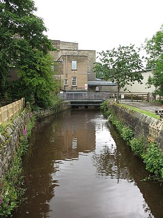
Glasshouses is a small village in Nidderdale, North Yorkshire, England. It lies 1 mile (1.6 km) south-east of Pateley Bridge on the east side of Nidderdale and has a recently rebuilt river bridge across the River Nidd. In 2019 it had an estimated population of 536.

Thruscross Reservoir is the northernmost of four reservoirs in the Washburn valley, lying north of Otley and west of Harrogate in North Yorkshire, England, near the hamlet of Thruscross. It can be found on an unclassified road from the A59 road. Permission to construct the reservoir was granted via a water order in 1960 and Thruscross was completed in 1966, much later than the other three reservoirs which date back to the nineteenth century.

Gouthwaite Reservoir is in Nidderdale, North Yorkshire, England. It is one of many reservoirs in the area, others include Roundhill Reservoir and Angram Reservoir.
Nidd Valley Light Railway was a light railway in upper Nidderdale in the West Riding of Yorkshire, England. It was owned by Bradford Corporation Waterworks Department and the corporation also operated its public passenger services. Power & Traction Ltd of London obtained a Light Railway Order for the 6.5-mile (10.5 km) railway from Pateley Bridge to Lofthouse in 1900, but these powers were taken over by Bradford Corporation. A contract to build Angram Reservoir was awarded to John Best & Son in 1903, and he also won the contract to build the public railway and a 6.5-mile (10.5 km) private extension to the reservoir site. This was initially built to 3 ft gauge but was converted to standard gauge by 1907, when the public railway opened. Best had his own locomotives, and Bradford Corporation equipped the public railway with second hand locomotives and carriages from the Metropolitan Railway.

The Nidd Valley Railway was a 11.5-mile (18.5 km) long single-track branch railway line that ran along the valley of the River Nidd in North Yorkshire, England. Built by the North Eastern Railway, it ran from Ripley Junction, on the Harrogate to Ripon Line, to Pateley Bridge via five intermediate stations, Ripley Valley, Hampsthwaite, Birstwith, Darley, and Dacre.
Stonebeck Up is a civil parish in Harrogate district, North Yorkshire, England. The only village in the parish is Middlesmoor. The population of the parish in the 2011 census was 119.
The Nidderdale Caves are a series of caves in Upper Nidderdale in North Yorkshire, England. There are two cave systems and most of the caves are in some way linked with one or the other. The smaller system is the Eglin cave system in the valley of How Stean Beck, a tributary of the River Nidd, associated with How Stean Gorge. The larger system is the Goyden cave system under the valley of the River Nidd, which flows east from Scar House Reservoir, then south, and shortly after disappears underground down several sink holes to reappear at the rising just beyond the village of Lofthouse. Cavers are able to access several sections of this system via the different entrances.

The Nidd Aqueduct is an aqueduct or man-made watercourse in North Yorkshire, England. It feeds water from Angram and Scar House reservoirs in upper Nidderdale, North Yorkshire 32 mi (51 km) to Bradford in West Yorkshire. The aqueduct supplies 21,000,000 imp gal (95,000 m3) of water per day to Chellow Heights water treatment works. The aqueduct and the reservoirs it connects to are all maintained by Yorkshire Water.

Scotgate Ash Quarry or Scot Gate Ash Quarry, was the collective name for extensive quarry workings that were on the northern edge of Pateley Bridge, North Yorkshire, England. When the quarry was last in use, the area was in the West Riding of Yorkshire, and was described as being the largest quarry in West Yorkshire.

Bradford Dale, is a side valley of Airedale that feeds water from Bradford Beck across the City of Bradford into the River Aire at Shipley in West Yorkshire, England. Whilst it is in Yorkshire and a dale, it is not part of the Yorkshire Dales and has more in common with Lower Nidderdale and Lower Airedale for its industrialisation.

The Yorkshire Water Way is a 104-mile (167 km) path that runs from Kettlewell in North Yorkshire to Langsett in South Yorkshire. It was devised by Mark Reid in conjunction with Yorkshire Water (YW) and it passes by over more than 20 reservoirs which are operated by Yorkshire Water.

Upper Barden Reservoir is an upland fresh water reservoir, one of two reservoirs that collect water from Barden Moor, and dam Barden Beck, a tributary of the River Wharfe in the Yorkshire Dales, North Yorkshire, England. The reservoir was opened in 1882 and also supplies fresh water to the Nidd Aqueduct, which transports it to Bradford. Upper Barden Reservoir was the second of the reservoirs to be built,.
Lofthouse-in-Nidderdale railway station was the northernmost regular passenger terminus on the Nidd Valley Light Railway (NVLR), in Lofthouse, then in the West Riding of Yorkshire and now in North Yorkshire, England. The station was built as part of Bradford Corporation's programme of reservoir building in the Upper Nidd Valley. The station opened in 1904 and was closed to passengers in 1930. The station was renamed Lofthouse-in-Nidderdale railway station in 1907 to avoid confusion with Lofthouse and Outwood railway station, also in the West Riding of Yorkshire.


