Yorkshire is a historic county in Northern England and the largest by area size in the United Kingdom. Because of its large area in comparison with other English counties, functions have been undertaken over time by its subdivisions, which have also been subject to periodic reform. Throughout these changes, Yorkshire has continued to be recognised as a geographic territory and cultural region.
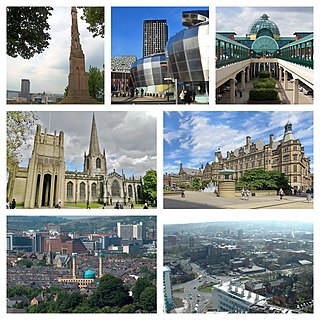
Sheffield is a city in South Yorkshire, England, whose name derives from the River Sheaf which runs through it. The city serves as the administrative centre of the City of Sheffield. It is historically part of the West Riding of Yorkshire and some of its southern suburbs were transferred from Derbyshire to the city council. It is the largest settlement in South Yorkshire.

Doncaster is a city in South Yorkshire, England. Named after the River Don, it is the administrative centre of the larger City of Doncaster. The city is the second largest settlement in South Yorkshire after Sheffield. It is situated in the Don Valley on the western edge of the Humberhead Levels and east of the Pennines. The urban subdivision had a population of 113,566 at the 2021 census, whilst the City of Doncaster metropolitan borough had a population of 308,106.

Bradfield is a civil parish in the City of Sheffield, in South Yorkshire, England.

Low Bradfield is a village within the civil parish of Bradfield in South Yorkshire, England. It is situated within the boundary of the city of Sheffield in the upper part of the Loxley Valley, 6¼ miles west-northwest of the city centre and just inside the northeast boundary of the Peak District National Park. Low Bradfield and the surrounding area is noted for its attractive countryside which draws many visitors from the more urban parts of Sheffield. At weekends the village can become quite crowded, especially when there is a match on the village cricket pitch. Low Bradfield which stands in the shadow of Agden Reservoir has a sister village High Bradfield which is located at a higher altitude, ½ mile to the northeast. The two villages are joined by the steep Woodfall Lane.

The Yorkshire Wildlife Trust is a charitable non-governmental organisation, one of the UK's 46 county-based Wildlife Trusts. Its focus is nature conservation and it works to achieve a nature-rich Yorkshire with healthy and resilient ecosystems that support both Yorkshire's wildlife and its people.

Yorkshire Water is a water supply and treatment utility company servicing West Yorkshire, South Yorkshire, the East Riding of Yorkshire, part of North Lincolnshire, most of North Yorkshire and part of Derbyshire, in England. The company has its origins in the Yorkshire Water Authority, one of ten regional water authorities created by the Water Act 1973, and privatised under the terms of the Water Act 1989, when Yorkshire Water plc, the parent company of the Yorkshire Water business, was floated on the London Stock Exchange. The parent company was Kelda Group in 1999. In February 2008, Kelda Group was bought by a consortium of infrastructure funds.

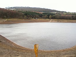
Agden Reservoir is a water storage reservoir, situated at grid reference SK260925, 6.5 miles (10 km) west of the centre of Sheffield, South Yorkshire, England. It is owned by Yorkshire Water / Kelda Group. The reservoir covers an area of 25 hectares (62 acres) and has a capacity of 559 million gallons (2.11x10⁹ litres) of water, the dam wall has a width of approximately 380 feet (120 m) with a height of 100 feet (30 m). 'Agden' means 'Valley of the Oak Trees'.

The Blackburn Brook is a stream in Sheffield, South Yorkshire, England which flows through the Blackburn Valley along the M1 and Ecclesfield Road and joins the River Don near the Meadowhall shopping centre. Downstream from the A61 road at Chapeltown the Blackburn Brook is defined as a main river by the Environment Agency, which requires new building development to be at least 26 feet (8 m) from the bank side as a flood defence measure and to allow access to the watercourse for maintenance.
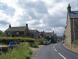
Bolsterstone is a village in South Yorkshire, England, south of Stocksbridge, and 8.5 miles to the northwest of the City of Sheffield and within the city borough. It lies on the border of the Peak District national park. Bolsterstone had a population of 386 in 2011.

The Church of St. Nicholas, Bradfield is situated in the small village of High Bradfield, which is located 6 miles (10 km) north west of the centre of the city of Sheffield in South Yorkshire, England. It is one of only five Grade One Listed buildings in Sheffield. The church is situated 260 metres (850 ft) above sea level, overlooking the Peak District National Park.

Ewden Valley is a valley in the civil parish of Bradfield in the Stocksbridge and Upper Don electoral ward of Sheffield, South Yorkshire, England.

Mount Pleasant is an 18th-century mansion situated on Sharrow Lane in the Highfield area of the City of Sheffield in South Yorkshire, England. The house stands just under two km south of the city centre and is a grade II* listed building, it has been described as "one of the best 18th century houses in Sheffield". The adjacent former stables and coach house are also Grade II* listed.

Sheffield & Rotherham Wildlife Trust is a charitable non-governmental organisation, covering Sheffield and Rotherham, South Yorkshire, England. It owns or manages 15 nature reserves with its base in Sheffield.

Potteric Carr is a large area of land to the southeast of Doncaster, in Yorkshire, England, over 3,000 acres (12 km2) in size.
Broomhead is a surname of English origin and was a surname based on the location of the person it was given to. This surname is most commonly found in North Central England.

Broomhead Reservoir is a reservoir located in the Ewden Valley, near Sheffield in South Yorkshire, England. The reservoir is located to the south of Bolsterstone and is linked to the More Hall Reservoir to the east. It covers 50 hectares of land and can hold more than 1,000 million gallons of water.

Broomhead Hall was a large English country house that stood in the Ewden valley, to the west of Sheffield, England. The hall stood near the hamlet of Wigtwizzle, to the west of Broomhead Reservoir.

Wigtwizzle is a hamlet in the civil parish of Bradfield, in South Yorkshire, England. The hamlet is 6 miles (9.7 km) south of Penistone, and 12 miles (19 km) north west of Sheffield.