
The River Douglas, also known as the River Asland or Astland, is a river that flows through Lancashire and Greater Manchester in the north-west of England. It is a tributary of the River Ribble and has itself several tributaries, the major ones being the River Tawd and the River Yarrow.

The Barnsley Canal is a canal that ran from Barnby Basin, through Barnsley, South Yorkshire, England to a junction with the Aire and Calder Navigation near Wakefield, West Yorkshire. It was built in the 1790s, to provide a transport link from coal reserves at Barnsley to a wider market. Both the Aire and Calder Navigation and the River Don Navigation took a keen interest in the project, the former buying many of the initial shares, and the latter constructing the Dearne and Dove Canal to link the canal to their waterway. Water supply issues meant that the Aire and Calder proposed pumping all of the water for the canal from the River Calder, using steam pumps, but a reservoir was built at Cold Hiendley instead, increasing the construction costs, but reducing the running costs. The canal as built was 14.5 miles (23.3 km) long and included 15 locks.

Kielder Water is a large man-made reservoir in Northumberland in North East England. It is the largest artificial lake in the United Kingdom by capacity of water and it is surrounded by Kielder Forest, one of the biggest man-made woodlands in Europe. The scheme was planned in the late 1960s to satisfy an expected rise in demand for water to support a booming UK industrial economy.

Derwent Reservoir is a reservoir on the River Derwent, on the border between County Durham and Northumberland, in England. It is west of Consett. It is one of the biggest inland waters in England. It is 3.5 miles (5.6 km) long) and covers an area of 4 km² and has a maximum depth of 100 ft (30m) and when full, holds 11,000 million gallons (50,000,000m³).

The Dearne and Dove Canal ran for almost ten miles through South Yorkshire, England from Swinton to Barnsley through nineteen locks, rising 127 feet (39 m). The canal also had two short branches, the Worsbrough branch and the Elsecar branch, both about two miles long with reservoirs at the head of each. The Elsecar branch also has another six locks. The only tunnel was bypassed by a cutting in 1840.
The Rochdale Canal is in Northern England, between Manchester and Sowerby Bridge, part of the connected system of the canals of Great Britain. Its name refers to the town of Rochdale through which it passes.

Dresden Generating Station is the first privately financed nuclear power plant built in the United States. Dresden 1 was activated in 1960 and retired in 1978. Operating since 1970 are Dresden units 2 and 3, two General Electric BWR-3 boiling water reactors. Dresden Station is located on a 953-acre (386 ha) site in Grundy County, Illinois, at the head of the Illinois River, near the city of Morris. It is immediately northeast of the Morris Operation—the only de facto high-level radioactive waste storage site in the United States. It serves Chicago and the northern quarter of the state of Illinois, capable of producing 867 megawatts of electricity from each of its two reactors, enough to power over one million average American homes.

Edgbaston Reservoir, originally known as Rotton Park Reservoir and referred to in some early maps as Rock Pool Reservoir, is a canal feeder reservoir in Birmingham, England., maintained by the Canal & River Trust. It is situated close to Birmingham City Centre and is a Site of Importance for Nature Conservation.

Hollingworth Lake is a 130-acre (53 ha) reservoir at Smithy Bridge, in Littleborough – part of the Metropolitan Borough of Rochdale, in Greater Manchester, England. The lake was originally built as the main water source for the Rochdale Canal, but developed as a tourist resort from the 1860s, and became known as the Weighver's Seaport. Hotels were built around it, at least two of which had outdoor dancing stages with gas lighting. Tourism was helped by the arrival of the railway in 1839, which brought day-trippers and weekend visitors from Manchester, Bradford and Leeds.

Yorkshire Water is a water supply and treatment utility company servicing West Yorkshire, South Yorkshire, the East Riding of Yorkshire, part of North Lincolnshire, most of North Yorkshire and part of Derbyshire, in England. The company has its origins in the Yorkshire Water Authority, one of ten regional water authorities created by the Water Act 1973, and privatised under the terms of the Water Act 1989, when Yorkshire Water plc, the parent company of the Yorkshire Water business, was floated on the London Stock Exchange. The parent company was Kelda Group in 1999. In February 2008, Kelda Group was bought by a consortium of infrastructure funds.

Bristol Water supplies 266 million litres of drinking water daily to over 1.2 million customers in a 2,600 km2 (1,000 sq mi) area centred on Bristol, England. It is regulated under the Water Industry Act 1991. Sewerage services in the Bristol area are provided by Wessex Water.

Angram Reservoir is the first of three reservoirs on the River Nidd in Upper Nidderdale, North Yorkshire, England, the others being Scar House Reservoir and finally the compensation reservoir Gouthwaite Reservoir. It is located at OS map reference SE040759. Between them they attract around 150,000 visitors a year.

Lindley Wood Reservoir is located in the Washburn valley north of Otley in Yorkshire, England.

Bosley Reservoir is a large reservoir created to feed the Macclesfield Canal system, specifically the twelve Bosley locks. It is fed from the surrounding hills, including Bosley Cloud which rises to 1,125 feet.

The Thirlmere Aqueduct is a 95.9-mile-long (154.3-kilometre-long) pioneering section of water supply system in England, built by the Manchester Corporation Water Works between 1890 and 1925. Often incorrectly thought of as one of the longest tunnels in the world, the aqueduct's tunnel section is not continuous.

Burley Woodhead is a hamlet in the City of Bradford, in West Yorkshire, England. The hamlet is 1 mile (1.6 km) to the south-west of Burley in Wharfedale and is approximately 3 miles (5 km) from the spa town of Ilkley. Burley Woodhead comprises chiefly of a small cluster of farms and homes along the road from Ilkley to Guiseley at the foot of Burley Moor, though the village is at 560 feet (170 m) above sea level, with the moor being some 1,300 feet (400 m) above sea level. The local public house is The Hermit.

Chelker Reservoir is a man-made lake in North Yorkshire, England. It lies in the parish of Draughton, immediately north of the A65 road, between Skipton and the village of Addingham. It was put into service in 1866 and serves the Bradford area; it is currently owned by Yorkshire Water. The reservoir's main inflow is the River Wharfe.

Rivelin Dams are a pair of water storage reservoirs situated in the upper part of the Rivelin Valley, 5 miles (8 km) west of Sheffield in South Yorkshire, England. The dams are owned by Yorkshire Water and provide water to 319,000 people as well as compensation water for the River Rivelin. They are named Upper and Lower and fall just within the eastern boundary of the Peak District.
Essex and Suffolk Water is a water supply company in the United Kingdom. It operates in two geographically distinct areas, one serving parts of Norfolk and Suffolk, and the other serving parts of Essex and Greater London. The total population served is 1.8 million. Essex and Suffolk is a 'water only' supplier, with sewerage services provided by Anglian Water and Thames Water within its areas of supply. It is part of the Northumbrian Water Group.

The Nidd Aqueduct is an aqueduct or man-made watercourse in North Yorkshire, England. It feeds water from Angram and Scar House reservoirs in upper Nidderdale, North Yorkshire 32 mi (51 km) to Bradford in West Yorkshire. The aqueduct supplies 21,000,000 imp gal (95,000 m3) of water per day to Chellow Heights water treatment works. The aqueduct and the reservoirs it connects to are all maintained by Yorkshire Water.


 Discharge portal into Winterburn beck.
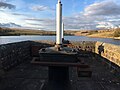 Twin cast iron valve capstans

