
The River Don is a river in South Yorkshire and the East Riding of Yorkshire, England. It rises in the Pennines, west of Dunford Bridge, and flows for 69 miles (111 km) eastwards, through the Don Valley, via Penistone, Sheffield, Rotherham, Mexborough, Conisbrough, Doncaster and Stainforth. It originally joined the Trent, but was re-engineered by Cornelius Vermuyden as the Dutch River in the 1620s, and now joins the River Ouse at Goole. Don Valley is a UK parliamentary constituency near the Doncaster stretch of the river.
The Porter Brook is a river which flows through the City of Sheffield, England, descending over 1,000 feet (300 m) from its source on Burbage Moor to the west of the city to its mouth where it joins the River Sheaf in a culvert beneath Sheffield railway station. Like the other rivers in Sheffield, its steep gradient made it ideal for powering water mills and works associated with the metalworking and cutlery industries, and around 20 dams were constructed over the centuries to facilitate this. At its lower end, it is extensively culverted, but parts of it are gradually being restored to open channels, as part of a daylighting scheme for the city.

Bradfield is a civil parish in the City of Sheffield, in South Yorkshire, England.

Low Bradfield is a village within the civil parish of Bradfield in South Yorkshire, England. It is situated within the boundary of the city of Sheffield in the upper part of the Loxley Valley, 6¼ miles west-northwest of the city centre and just inside the northeast boundary of the Peak District National Park. Low Bradfield and the surrounding area is noted for its attractive countryside which draws many visitors from the more urban parts of Sheffield. At weekends the village can become quite crowded, especially when there is a match on the village cricket pitch. Low Bradfield which stands in the shadow of Agden Reservoir has a sister village High Bradfield which is located at a higher altitude, ½ mile to the northeast. The two villages are joined by the steep Woodfall Lane.

Ponds Forge International Sports Centre is a leisure complex in Sheffield, England. It has an Olympic-sized swimming pool with 2,600 seating capacity, a family and children's pools, water slides amongst other facilities.
The River Loxley is a river in the City of Sheffield, South Yorkshire, England. Its source is a series of streams which rise some 10 miles (16 km) to the north-west of Sheffield on Bradfield Moors, flowing through Bradfield Dale to converge at Low Bradfield. It flows easterly through Damflask Reservoir and is joined by Storrs Brook at Storrs, near Stannington, and the River Rivelin at Malin Bridge, before flowing into the River Don at Owlerton, in Hillsborough. The Loxley valley provided the initial course of the Great Sheffield Flood, which happened after the Dale Dyke Dam collapsed shortly before its completion in March 1864.

The Little Don River also known as the Porter, is a tributary of the River Don in South Yorkshire, England. Arising on the Langsett Moors in the northern Peak District, the Little Don River feeds the Langsett and Underbank Reservoirs. It runs through the town of Stocksbridge before joining the River Don.

Yorkshire Water is a British water supply and treatment utility company servicing West Yorkshire, South Yorkshire, the East Riding of Yorkshire, part of North Lincolnshire, most of North Yorkshire and part of Derbyshire, in England. The company has its origins in the Yorkshire Water Authority, one of ten regional water authorities created by the Water Act 1973, and privatised under the terms of the Water Act 1989, when Yorkshire Water plc, the parent company of the Yorkshire Water business, was floated on the London Stock Exchange. The parent company was Kelda Group in 1999. In February 2008, Kelda Group was bought by a consortium of infrastructure funds.

Agden Reservoir is a water storage reservoir, situated at grid reference SK260925, 6.5 miles (10 km) west of the centre of Sheffield, South Yorkshire, England. It is owned by Yorkshire Water / Kelda Group. The reservoir covers an area of 25 hectares (62 acres) and has a capacity of 559 million gallons (2.11x10⁹ litres) of water, the dam wall has a width of approximately 380 feet (120 m) with a height of 100 feet (30 m). 'Agden' means 'Valley of the Oak Trees'.

The River Alport flows for 5.6 miles (9 km) in the Dark Peak of the Peak District in Derbyshire, England. Its source is on Bleaklow, 3 miles (4.8 km) east of Glossop, from which it flows south through the Grains in the Water bog, then over gritstone below the Alport Castles landslide to Alport Bridge on the A57 Snake Pass route from Sheffield to Manchester, where it joins the River Ashop. The Ashop flows into Ladybower Reservoir about 2.5 miles (4.0 km) down the valley, which discharges via the Rivers Derwent and Trent to the North Sea. The source of the Alport is close to the Pennine watershed.

Chatfield Dam and Reservoir is a dam and artificial lake located on the South Platte River, south of Littleton, Colorado. The dam and reservoir were built by the United States Army Corps of Engineers as a response to the disastrous flood of 1965. In addition to its primary purpose of flood control, it serves as one of many water supply reservoirs for the city of Denver, Colorado.

Cull Canyon Regional Recreation Area (CCRRA) is a regional park located in Castro Valley, Alameda County, California. It is part of the East Bay Regional Park District (EBRPD) system.

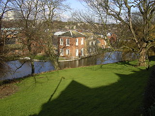
Hillsborough House, later called Hillsborough Hall, is a large, stone-built mansion constructed in the Adam style in the latter part of the 18th century. It stands 2+1⁄2 miles north-west of the centre of Sheffield at grid reference SK331901 in the suburb of Hillsborough within Hillsborough Park, a council-owned public recreational area. For 124 years the house was a private dwelling, but since 1906 it has housed the Hillsborough branch library. It is a Grade II listed building as are the coach house and stables which stand 22 yards (20 m) north-west of the main house.

Blackburn Meadows is an area of land just inside the Sheffield city border at Tinsley, England. It became the location of the main sewage treatment works for the city in 1884, and is now one of the largest treatment works in Britain. The treatment process was rudimentary, with sludge being removed to ponds and then to drying beds, after which it was used as manure or transferred by rail to a tip at Kilnhurst. The works progressively expanded to improve the quality of effluent discharged to the River Don and was a pioneer in the use of bio-aeration, following experiments by the works manager during the First World War. This process became known as the "Sheffield System", and was demonstrated to visitors from Great Britain and abroad. Despite these improvements, ammonia levels in the river below the works were high, and fish populations did not survive.

Crookes Valley Park is an area of public parkland in the Crookesmoor area of the City of Sheffield in South Yorkshire, England. The park lies just under two kilometres west of the City centre at 53.3834°N 1.4929°W. It is one of the three “Crookesmoor Parks” the other two being Weston Park and The Ponderosa.

Ewden Valley is a valley in the civil parish of Bradfield in the Stocksbridge and Upper Don electoral ward of Sheffield, South Yorkshire, England.

Broomhead Hall was a large English country house that stood in the Ewden valley, to the west of Sheffield, England. The hall stood near the hamlet of Wigtwizzle, to the west of Broomhead Reservoir.

Upper Barden Reservoir is an upland fresh water reservoir, one of two reservoirs that collect water from Barden Moor, and dam Barden Beck, a tributary of the River Wharfe in the Yorkshire Dales, North Yorkshire, England. The reservoir was opened in 1882 and also supplies fresh water to the Nidd Aqueduct, which transports it to Bradford. Upper Barden Reservoir was the second of the reservoirs to be built,.

More Hall Reservoir is a reservoir located in the Ewden valley near Sheffield, South Yorkshire, England. The reservoir is situated to the south of Bolsterstone and is linked to the Broomhead Reservoir to the west.

Wigtwizzle is a hamlet in the civil parish of Bradfield, in South Yorkshire, England. The hamlet is 6 miles (9.7 km) south of Penistone, and 12 miles (19 km) north west of Sheffield.


