This article needs additional citations for verification .(April 2010) |

Cathall is a housing estate in the Cathall ward, Leytonstone, East London. It is currently managed by Community-based Housing Association.
This article needs additional citations for verification .(April 2010) |
Cathall is a housing estate in the Cathall ward, Leytonstone, East London. It is currently managed by Community-based Housing Association.
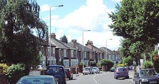
Cathall estate was built in 1972, consisting of two 20-storey tower blocks, Hornbeam Tower and Redwood Tower, and a network of 8-storey flats. It became one of Britain's poorest areas with extreme levels of poverty and crime.[ citation needed ] Cathall estate and the surrounding area of Leytonstone has often been known to have a large gang culture.
In the late 1990s, the estate began to be regenerated into a low-rise housing estate by the Waltham Forest Housing Action Trust and its successor landlord, Community-based Housing Association. Similar Housing Action Trust schemes were set up across Waltham Forest and Tower Hamlets in East London, Brent in North West London, Liverpool, Hull and Birmingham.
Despite widespread opposition, it was announced in 2015 that the Community-Based Housing Association would be taken over by the Peabody Trust. [1] [2] Peabody controversially 'sacked the board' in July 2015 for rejecting their takeover plans. [3] The board included residents of the Cathall estate. [3] Peabody later placed their own officers on the board. [4]
Following the removal of the tower blocks, Cathall's most prominent feature is now its leisure centre.

Leyton is a town in east London, England, within the London Borough of Waltham Forest. It borders Walthamstow to the north, Leytonstone to the east, and Stratford to the south, with Clapton, Hackney Wick and Homerton, across the River Lea, to the west. The area includes New Spitalfields Market, Leyton Orient Football Club, as well as part of the Queen Elizabeth Olympic Park. The town consists largely of terraced houses built between 1870 and 1910, interspersed with some modern housing estates. It is 6.2 miles (10 km) north-east of Charing Cross.
Walthamstow is a town in the London Borough of Waltham Forest, around 7.5 miles (12 km) east of Central London. The town borders Chingford to the north, Snaresbrook and South Woodford to the east, Leyton and Leytonstone to the south, and Tottenham to the west. At the 2011 census, the town had a population of approximately 109,424.
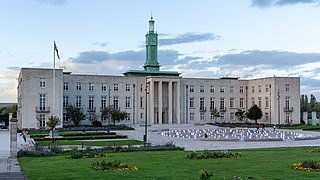
The London Borough of Waltham Forest is an outer London borough formed in 1965 from the merger of the municipal boroughs of Leyton, Walthamstow and Chingford.

Commercial Street is an arterial road in Tower Hamlets, east London that runs north to south from Shoreditch High Street to Whitechapel High Street through the East End district of Spitalfields. The road is a section of the A1202 London Inner Ring Road and as such forms part of the boundary of the London congestion charge zone.

Leytonstone is an area in east London, England, within the London Borough of Waltham Forest. It adjoins Wanstead to the north-east, Forest Gate to the south-east, Stratford to the south-west, Leyton to the west, and Walthamstow to the north-west, and is 7 miles (11 km) north-east of Charing Cross.

Leyton is a London Underground station in Leyton, in the London Borough of Waltham Forest, East London. Located on Leyton High Road, adjacent to the A12, the station is on the Central line between Stratford and Leytonstone stations. It is in Travelcard zone 3.
Oliver Close Estate is a housing estate in Leyton, London Borough of Waltham Forest in East London, England. From 1967 to 1996 the estate contained 500 flats in five high-rise buildings. It is currently owned and administered by the Community-based Housing Association.
Leyton Grange, in Leyton, east London, is the second most deprived area of the London Borough of Waltham Forest. It include an estate that consists of a 10-storey tower and ten 4-storey courts owned by Forest Homes.

The Peabody Trust was founded in 1862 as the Peabody Donation Fund and now brands itself simply as Peabody. It is one of London's oldest and largest housing associations with over 100,000 homes across London and the home counties. It is also a community benefit society and urban regeneration agency, with a focus on placemaking, stewardship and a provider of an extensive range of community programmes.

Whipps Cross University Hospital is a large university hospital in the locality of Whipps Cross in Leytonstone and is within Epping Forest in the London Borough of Waltham Forest, London, England. It is managed by Barts Health NHS Trust.
Beaumont Road is a housing estate located in Leyton in East London. It is the largest housing estate in the borough of Waltham Forest. It is situated just south of the Bakers Arms, on Leyton High Road.
Cann Hall is a former civil parish in the south of Leytonstone in the London Borough of Waltham Forest. It is north of Stratford and Forest Gate, east of Leyton, and west of Wanstead Flats, the southernmost tip of Epping Forest.

Wanstead Flats is the southernmost portion of Epping Forest, in Leytonstone and Wanstead, London. The flats and by extension the forest ends at Forest Gate directly to the south. It now falls wholly within the boundaries of the London Boroughs of Redbridge and Waltham Forest, though until 1994 two parts of it were in the London Borough of Newham: one of these was the section between Aldersbrook Road and Capel Road east of the junction between Aldersbrook Road and St Margaret's Road, whilst the other was the strip running along Capel Road between its junctions with Centre Road and Ridley Road. As part of Epping Forest, the Flats is managed by the City of London Corporation.
Housing action trusts (HAT) were non-departmental public bodies, set up to redevelop some of the poorest council housing estates in England's inner-city suburbs.
The Clays Lane Estate was a housing estate in Stratford, east London, and the UK’s largest purpose built housing cooperative. It was an experiment in building close-knit communities as a way of helping vulnerable single people. It became the subject of significant controversy when it was demolished to make way for the site of the London 2012 Olympic games.

The 491 Gallery was a squatted self-managed social centre and multi-disciplinary gallery in Leytonstone, London, England, that operated from 2001 to 2013. Taking its name from its street number, 491 Grove Green Road, the former factory was home to a community-led art organisation and served as an exhibition space for a diverse range of artists of different origins working in varied media. It contained a range of art and music studios, which were used to host workshops, classes and musical rehearsals. The building was subsequently demolished in 2016.

The Cranbrook Estate is a housing estate in Bethnal Green, London, England. It is located next to Roman Road and is based around a figure of eight street called Mace Street. The estate was designed by Francis Skinner, Douglas Bailey and an elder mentor, the Soviet émigré Berthold Lubetkin.

The Warner Estate is an area of housing in Walthamstow and Highams Park, Waltham Forest in East London. The area was developed by Thomas Courtenay Warner and the Warner Company.
Holloway Down was a village, historically in Essex and now part of Leytonstone in the London Borough of Waltham Forest. The village was sited at the junction of Union Lane and Leytonstone Road It is most notable as the location of the West Ham Union Workhouse, While the village has been replaced by Victorian terraces and shops, buildings from the workhouse remain; which have been converted into housing and part of North East London NHS Foundation Trust.

The Church of St Andrew, Leytonstone, is a Victorian era Church of England parish church in Leytonstone, East London, adjacent to Epping Forest. It is a Grade II listed building.
51°33′32″N0°00′20″E / 51.5588°N 0.0055°E
| | This article about a London building or structure is a stub. You can help Wikipedia by expanding it. |