Clifton is a suburb of York in the unitary authority area of the City of York, in North Yorkshire, England about 1+1⁄2 miles from the city centre. The A19, passes north out of York through Clifton.

Haxby is a town and civil parish in the City of York district of North Yorkshire, England. According to the 2001 Census, the parish had a population of 8,754, which reduced to 8,428 at the 2011 Census.

Heworth is part of the city of York in North Yorkshire, England, about 1 mile (1.6 km) north-east of the centre. No longer in general referred to as a village, "Heworth Village" is now the name of a specific road. The name "Heworth" is Anglo-Saxon and means a "high enclosure".

Osbaldwick is a village and civil parish in the unitary authority of the City of York in North Yorkshire, England. The population of the civil parish as taken at the 2011 census was 2,902. It has been in existence since at least the 11th century, and was declared a conservation area in 1978. It is the burial place of the nun Mary Ward.

Hemsworth is a town and civil parish in the City of Wakefield, West Yorkshire, England. Historically within the West Riding of Yorkshire and had a population of 13,311 at the 2001 census, with it increasing to 13,533 at the 2011 Census.
Elections to City of York Council were held on 6 May 1999. All 53 council seats in the city were up for election and the Labour Party kept overall control of the council.
Elections to City of York Council were held in 2003. The whole council was up for election. Boundary changes had reduced the number of seats from 53 to 47.
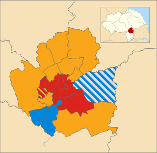
Local elections for City of York Council were held on Thursday 3 May 2007. The whole council was up for election. Of the 47 seats contested, the Liberal Democrats won 19 seats, Labour won 18 seats, Conservatives won eight seats and the Green Party won two seats. The election saw York's ruling Liberal Democrats lose ten seats and overall control of the council.
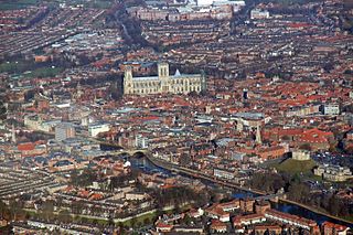
The City of York, officially simply "York", is a unitary authority area with city status in the ceremonial county of North Yorkshire, England.

Holgate is a suburb of York in the ceremonial county of North Yorkshire, England. It is located about 1 mile west of Micklegate Bar in the city walls. Holgate is also the name of an electoral ward in the City of York unitary authority. The ward is currently bounded by the River Ouse from Scarborough Bridge to Ouse Acres on its northern boundary. Carr Lane and Ouse Acres on one side, and the intersection of York Road and Acomb Road on the other, make up its western boundary. The remainder of the southern boundary follows Moorgate and Holgate Beck to the East Coast Main Line railway which completes the eastern boundary as far as the River Ouse/Scarborough Bridge.

Elections to City of York Council were held on Thursday 5 May 2011. The whole council was up for election. The vote took place alongside the 2011 United Kingdom Alternative Vote referendum.
Burnholme Community College was a high school on the east side of York, North Yorkshire. It served the suburbs of Heworth, Tang Hall and parts of Osbaldwick. Due to declining enrolment, the college closed in 2014. Most of its pupils were transferred to Archbishop Holgate's School, which is less than 3 mi (4.8 km) away from the former school site. Some pupils also transferred to Huntington School and Joseph Rowntree School with school buses being provided to serve the area of Tang Hall.

The 2015 City of York Council election took place on 7 May 2015 to elect members of City of York Council in England. The whole council was up for election. Turnout was substantially up across the city due to the election being held on the same day as the general election and other local elections in England.
Elections to the new City of York unitary authority were held on 4 May 1995, although the new unitary authority wasn't officially created until April 1996. All 53 council seats in the city were up for election and the Labour Party won overall control of the council.

Elections to City of York Council were held on 2 May 2019, as part of the United Kingdom local elections. The election resulted in substantial gains for the Liberal Democrats, who became the largest party, although no party surpassed the 24-seat majority threshold. The Conservatives suffered badly in this election, and lost 12 of the 14 seats they had won at the previous election. The Green Party held all their four seats, and surpassed the Conservatives in the popular vote. Labour gained two seats, although they failed to gain support in rural areas, where voters favoured the Liberal Democrats. On 14 May, The Liberal Democrats and the Green Party announced that they had agreed to run the council in a new 'progressive partnership' coalition, with Green Party leader Andy D'Agorne assuming the role of Deputy Leader of the Council while Liberal Democrat leader Keith Aspden succeeded Ian Gillies as Leader of the Council.
Elections to City of York Council took place on 4 May 2023, as part of the United Kingdom local elections. They were held on the same day as other local elections in England. The incumbent leader of the council and leader of the Liberal Democrats, Keith Aspden did not stand for re-election, with it being announced ahead of the elections that Nigel Ayre would be the Liberal Democrats' new leader.

Hull Road Park is a 25-acre (10 ha) open-space park in the suburb of Tang Hall, York, in Northern England. The park is bordered on its southern edge by Osbaldwick Beck, which has become a home for the endangered water vole. The City of York Council withdrew support for the park in 2011, and it is maintained and cleaned by a network of volunteers working for several different societies.