Osbaldwick

Last updated

Osbaldwick
Osbaldwick1.JPG
Osbaldwick village
North Yorkshire UK location map (2023).svg
Red pog.svg
Osbaldwick
Location within North Yorkshire
Population2,902 (2011)
OS grid reference SE634518
Civil parish
  • Osbaldwick
Unitary authority
Ceremonial county
Region
Country England
Sovereign state United Kingdom
Post town YORK
Postcode district YO10
Police North Yorkshire
Fire North Yorkshire
Ambulance Yorkshire
UK Parliament
List of places
UK
England
Yorkshire
53°57′31″N1°02′11″W / 53.9585°N 1.0365°W / 53.9585; -1.0365

Osbaldwick is a village and civil parish in the unitary authority of the City of York in North Yorkshire, England. The population of the civil parish as taken at the 2011 census was 2,902. [1] It has been in existence since at least the 11th century, and was declared a conservation area in 1978. It is the burial place of the nun Mary Ward.

Contents

History

It is mentioned three times in the Domesday Book as Osboldewic. [2] It is named after Osbald, an earl in the kingdom of Northumbria. At that time the manor was assessed with the city of York and the lands held by the Church of St Peter, York. It was the first Norman Archbishop of York that created the office of Prebend of Osbaldwick. The earliest mention of an incumbent of this office was of Richard le Brun in 1270. The office was de facto lord of the manor of the village. In 1852, the Church was allowed to sell off land and Osbaldwick Manor was sold to a Thomas Samuel Watkinson, later the Lord Mayor of York. [3]

The village was historically part of the North Riding of Yorkshire until 1974. It was then a part of the district of Ryedale in North Yorkshire from 1974 until 1996. Since 1996 it has been part of the City of York unitary authority. [4]

Governance

The village is within the York Outer UK Parliament constituency. It is also part of the Osbaldwick and Derwent Ward within York Unitary Authority. [5]

Geography

Osbaldwick Beck Osbaldwick Beck - geograph.org.uk - 798834.jpg
Osbaldwick Beck

Osbaldwick is now effectively a suburb of York, about 2 miles (3.2 km) east of the city. The village proper lies mostly along one street called Osbaldwick Village. Newer housing surrounds this and Osbaldwick is now effectively bounded on three sides by the A1079 to the south, the A64 that forms part of York's Ring Road) to the east and by green-belt land to the north. To the west, newer housing merges into the Tang Hall district.

Light industrial/trading estates exist to the east of the village heading towards Murton) and along Osbaldwick Link Road which links it to the A1079. A new (2006) housing development built in 2006, known as Murton Gardens, was built by Wimpey Homes on the link road on the site of a farm building and surrounding fields. A development known as Derwenthorpe was granted planning permission on 10 May 2007 for the green-belt land north of the village. Some farmland also exists between Osbaldwick and Murton.

Osbaldwick Beck runs through the village and is part of the tributary system of the River Foss. [6]

Demography

The 1881 UK census recorded the population as 340. [7] According to the 2001 UK census the parish had a population of 2,726, of which 2,299 were over the age of sixteen years and 1,115 of those were in employment. There were 1,200 dwellings of which 364 were detached. [8]

Transport

Between 1913 and 1926 Osbaldwick was served by a station on the Derwent Valley Light Railway. [9] This line remained open to freight until 1981, and in 1992, Sustrans converted the trackbed into National Cycle Route 66 from the village into York. [10] [11]

Osbaldwick is also served by two bus routes operated by First York on their service 6 between Clifton Moor and University Campus East and Transdev York on their service 20 between Rawcliffe and Osbaldwick (Limited service frequency).

Landmarks

The village is home to Osbaldwick Hall, a Grade II Listed Building, [12] and to the 12th century St Thomas' Church.

Eliza Raine (1793–1860) is buried in St. Thomas cemetery. Raine was the first partner to the celebrated English landowner and diarist Anne Lister. [13]

Facilities

B&Q Superstore BandQ - geograph.org.uk - 338271.jpg
B&Q Superstore

Education in the village is provided by Osbaldwick Primary School, [14] and most pupils transfer after Year 6 to Archbishop Holgate's School. [15]

The village post office closed in July 2003. [16] [17]

Derwent Arms

The Derwent Arms Derwent Arms.jpg
The Derwent Arms

The Derwent Arms, in the old part of the village, was built in 1823 when it was known as The Black Bull. It consisted of the main pub house and a stable for two horses with a granary over it. To the right were two cow houses with a small orchard and pig pen behind. In front of this was another outbuilding. In the early years the pub had a wash house. Later, a long cattle shed for eight to nine cows was added onto the west side of the stable. [18] It was later renamed The Derwent Arms after the Derwent Valley Light Railway which used to run through the village. It currently consists of a rendered brick building with the public rooms on the ground floor and accommodation for the owners above. The pub has a large field which is used to host community events such as the village fair and a bonfire night. [19] [20]

The Magnet pub, near the newer houses on Osbaldwick Lane, closed in 2018. [21]

Religion

The 12th-century Church of England parish church dedicated to St Thomas originally dates from the 12th century. Windows in the north wall date from the 12th, 13th and 14th century. The church has been reordered and extended on a number of occasions, notably in 1877 by John Oldrid Scott [22] and by later architects in both 1967 and 2005.

The Rev. William Ball Wright, noted genealogist and one of the first SPG Anglican missionaries to Japan, served as vicar of the parish from 1903 to 1912. [23] [24]

A window in the church is a memorial to former Sheriff and Lord Mayor of York, James Barber. [7] It is the burial place of the Roman Catholic nun Mary Ward, who founded the Institute of the Blessed Virgin Mary, also known as the Sisters of Loreto. The Church registers show that a Dorothy Paston Bedingfield, a superior of the order, was also buried here. [3]

Related Research Articles

<span class="mw-page-title-main">Huntington, North Yorkshire</span> Village and civil parish in York, England

Huntington is a village and civil parish in the unitary authority of City of York in North Yorkshire, England. It is part of the Huntington & New Earswick ward and lies on the River Foss, to the north of York and the south of Strensall.

<span class="mw-page-title-main">Fulford, North Yorkshire</span> Village and civil parish in North Yorkshire, England

Fulford is a historic village and civil parish on the outskirts of York, in the York district, in the ceremonial county of North Yorkshire, England. Fulford is located 2 miles (3 km) to the south of the city, on the east bank of the River Ouse.

<span class="mw-page-title-main">Ryedale</span> Former local government district in England

Ryedale was a non-metropolitan district in North Yorkshire, England. It was in the Vale of Pickering, a low-lying flat area of land drained by the River Derwent. The Vale's landscape is rural with scattered villages and towns. It has been inhabited continuously from the Mesolithic period. The economy was largely agricultural with light industry and tourism playing an increasing role.

<span class="mw-page-title-main">Dunnington</span> Village and civil parish in North Yorkshire, England

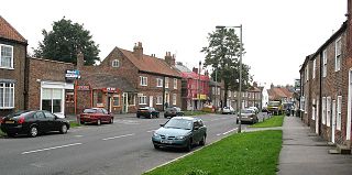
Dunnington is a village and civil parish in the City of York and ceremonial county of North Yorkshire, England. The population of the civil parish was 3,230 at the 2011 census. The village is approximately 4 miles (6 km) east from York city centre. The parish includes the hamlet of Grimston.

<span class="mw-page-title-main">Wheldrake</span> Village and civil parish in North Yorkshire, England

Wheldrake is a village and civil parish located 7 miles (11 km) south-east of York in the unitary authority of the City of York, which is in the ceremonial county of North Yorkshire, England. According to the 2001 census the parish had a population of 1,909, increasing to 2,107 at the 2011 census.

<span class="mw-page-title-main">Derwent Valley Light Railway</span> Railway line in Yorkshire, England

The Derwent Valley Light Railway (DVLR) (also known as The Blackberry Line) was a privately owned standard-gauge railway in North Yorkshire, England, and was unusual in that it was never nationalised, remaining as a private operation all its life. It ran between Layerthorpe on the outskirts of York to Cliffe Common near Selby. It opened in two stages, in 1912 and 1913, and closed in sections between 1965 and 1981. Between 1977 and 1979, passenger steam trains operated between Layerthorpe and Dunnington – the entire length of track at that time. In 1993 a small section was re-opened as part of the Yorkshire Museum of Farming at Murton.

<span class="mw-page-title-main">Barmby Moor</span> Village and civil parish in the East Riding of Yorkshire, England

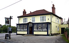
Barmby Moor is a village and civil parish in the East Riding of Yorkshire, England. It is situated approximately 1.5 miles (2.4 km) west of the market town of Pocklington and 12.5 miles (20 km) east-southeast of the city of York. It lies north of the A1079 road where it is met by the B1246 road that passes through the village.

<span class="mw-page-title-main">Murton, North Yorkshire</span> Village and civil parish in North Yorkshire, England

Murton is a small village and a civil parish in the unitary authority of the City of York in North Yorkshire, England that is located on the outskirts of York. To the west there is the A64 and the village of Osbaldwick, to the south the A166 road to Bridlington, to the north the village of Stockton-on-the-Forest, and to the east the villages of Holtby and Warthill.

<span class="mw-page-title-main">Stockton-on-the-Forest</span> Village and civil parish in North Yorkshire, England

Stockton-on-the-Forest is a village and civil parish in the unitary authority of the City of York in North Yorkshire, England.

<span class="mw-page-title-main">Stillington, North Yorkshire</span> Village and civil parish in North Yorkshire, England

Stillington is a village and civil parish in the district and county of North Yorkshire, England. It lies on the York to Helmsley road about 10 miles (16 km) north of York. Stillington Mill was the endpoint of the Foss Navigation Act of 1793.

<span class="mw-page-title-main">Holtby</span> Village and civil parish in North Yorkshire, England

Holtby is a small village and civil parish in the unitary authority of the City of York in North Yorkshire, England. The population at the 2011 Census was 166. It lies close to the A166 about 5 miles (8 km) east of York.

<span class="mw-page-title-main">Naburn</span> Village and civil parish in North Yorkshire, England

Naburn is a small village and civil parish in the unitary authority of the City of York in the ceremonial county of North Yorkshire, England. It lies on the eastern side of the River Ouse about 4 miles (6.4 km) south of York. According to the 2001 census the parish had a population of 470, increasing to 516 at the 2011 census.

<span class="mw-page-title-main">Kexby, North Yorkshire</span> Village and civil parish in North Yorkshire, England

Kexby is a village and civil parish in the unitary authority of the City of York in North Yorkshire, England. It lies on the River Derwent and on the A1079 road about 5 miles (8 km) east of York not far from the East Riding of Yorkshire border.

<span class="mw-page-title-main">Thorganby, North Yorkshire</span> Village and civil parish in North Yorkshire, England

Thorganby is a small village and civil parish in North Yorkshire, England. It was historically part of the East Riding of Yorkshire until 1974, but from 1974 to 2023 was in the Selby District of the shire county of North Yorkshire. In 2023 the district was abolished and North Yorkshire became a unitary authority.

<span class="mw-page-title-main">Hemingbrough</span> Village and civil parish in North Yorkshire, England

Hemingbrough is a small village and civil parish in North Yorkshire, England that is located approximately 5 miles (8 km) from Selby and 4 miles (6.4 km) from Howden on the A63. It was in the historic East Riding of Yorkshire, but since 1974 has come under North Yorkshire. The village has a 12th-century former collegiate church, a Methodist chapel and shops. The village also has a primary school and nursery as well as a playing field for the local children. The surrounding area makes up part of the Humberhead Levels and is flat land mainly used for mixed agriculture. It is thought that from this village came Walter of Hemingbrough, one of Britain's early chroniclers. Writing in the 14th century, he gave us a history beginning with the Norman conquest, now in the British Museum.

<span class="mw-page-title-main">Carlton, Selby</span> Village and civil parish in North Yorkshire, England

Carlton is a village and civil parish in southern North Yorkshire, England. The village is situated approximately 5 miles (8 km) south-east of the town of Selby on the A1041 road. The parish had a population of 1,934 at the 2011 Census, an increase from 1,829 at the 2001 Census.

<span class="mw-page-title-main">Catton, East Riding of Yorkshire</span> Civil parish in England

Catton is a civil parish in the East Riding of Yorkshire, England. It is situated 6 miles (10 km) to the north-west of the market town of Pocklington and covering an area of 1,233 hectares . It lies on the east bank of the River Derwent that forms the boundary with the unitary authority of the City of York. The A1079 road crosses the river just north of Kexby Old Bridge which is designated a Grade II* listed building in and is now recorded in the National Heritage List for England, maintained by Historic England.

<span class="mw-page-title-main">City of York</span> Unitary authority area in North Yorkshire, England

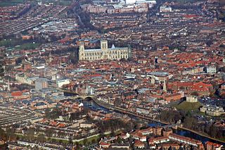
The City of York, officially simply "York", is a unitary authority area with city status in the ceremonial county of North Yorkshire, England.

York and its district, the City of York, has many distinct localities, suburbs and villages.

National Cycle Network (NCN) Route 66 is a Sustrans National Route that runs from Kingston upon Hull to Manchester via Beverley, York and Leeds.

References

  1. UK Census (2011). "Local Area Report – Osbaldwick Parish (E04000614)". Nomis. Office for National Statistics . Retrieved 21 August 2024.
  2. Osbaldwick in the Domesday Book . Retrieved 5 January 2013.
  3. 1 2 "Parishes: Osbaldwick | British History Online". british-history.ac.uk. Retrieved 21 August 2024.
  4. "History of Osbaldwick, in York and North Riding | Map and description". www.visionofbritain.org.uk. Retrieved 28 November 2020.
  5. "Election Maps". ordnancesurvey.co.uk. Retrieved 21 August 2024. On the left of the screen is the "Boundary" tab; click this and activate either wards or Westminster Constituencies (or both), however, only two functions can be active at any one time.
  6. "Tang Hall Bk/Old Foss Bk catch, trib of River Foss | Catchment Data Explorer | Catchment Data Explorer". environment.data.gov.uk. Retrieved 21 August 2024.
  7. 1 2 Bulmer's Topography, History and Directory (Private and Commercial) of North Yorkshire 1890. S&N Publishing. 1890. pp. 770, 771. ISBN   1-86150-299-0.
  8. UK Census (2001). "Local Area Report – Osbaldwick Parish (00FF023)". Nomis. Office for National Statistics . Retrieved 21 August 2024.
  9. "LNER Encyclopedia: The North Eastern Railway: Derwent Valley Light Railway". lner.info. Retrieved 22 August 2024.
  10. "Sustrans Route 66". Archived from the original on 9 August 2011. Retrieved 5 January 2013.
  11. Suggitt, Gordon (2007). Lost railways of North and East Yorkshire. Newbury: Countryside Books. p. 130. ISBN   978-1-85306-918-5.
  12. "Listed Building" . Retrieved 5 January 2013.
  13. "The parish of St Thomas Osbaldwick with St James Murton | About the Parish | St Thomas's". www.osbaldwickandmurtonchurches.org.uk. Retrieved 7 June 2020.
  14. Osbaldwick Primary School
  15. Archbishop Holgate's School
  16. "Village loses post office". Gazette & Herald. 13 November 2003. Retrieved 21 August 2024.
  17. "Anger at N Yorks post offices closure revelation". York Press. 23 May 2003. Retrieved 21 August 2024.
  18. Wilde, David. David Wilkinson (ed.). Osbaldwick: A suburban village.
  19. Cooper, Joe (5 April 2022). "Plan put forward to save York pub – just 350m away from another that has been left to rot". YorkMix. Retrieved 21 August 2024.
  20. "Remember, remember". York Press. 31 October 2002. Retrieved 21 August 2024.
  21. Laversuch, Chloe (2 March 2021). "Heritage pub to become homes". York Press. Retrieved 9 November 2023.
  22. "About the Parish". The Parish of Osbaldwick with Merton.
  23. "Lost Clergymen: Mystery of 400 Clerics, Missing Yorks Vicar". New Zealand Herald. Vol. L, no. 15269. 5 April 1913.
  24. "Rev. W.B. Wright of Tokyo". The Library of Nineteenth-Century Photography.